
Station GS OK049 - E0420 Rd and N3200 Rd, OK, USA
Network: GS - US Geological Survey Networks
Nearby stations (2 deg radius)

| Station | Name | (Lat, Lon) | Start / End | Elevation |
| OK049 | E0420 Rd and N3200 Rd, OK, USA | (36.41, -97.30) | 2016-09-09 / 2599-12-31 | 327 m |
| Crust2 Type: | D5,thick Platform 2 km seds. |
| Thickness Estimate: | 32 km |
| Thickness StdDev: | 14 km |
| Vp/Vs Estimate: | 1.61 |
| Vp/Vs StdDev: | 0.19 |
| Vs Estimate: | 4.033 km/s |
| Poisson's Ratio: | 0.18 |
| Peak Value: | 0.04 |
| Assumed Vp: | 6.483 km/s |
| Ps Weight: | 0.33333334 |
| PpPs Weight: | 0.33333334 |
| PsPs Weight: | 0.33333328 |
| Residual Complexity: | 0.852 |
| Nearby stations H: | +- |
| (2.0 deg) Vp/Vs: | +- |
2 with match > 90% ( 20.0 %) and 3 with match > 80% ( 30.0 %) out of 10.
Download stack as xyz text file.
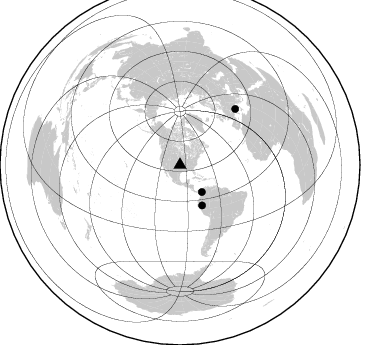
Azimuth Distribution of Events:
Prior Results for this Station
| Study | Thickness | Vp/Vs | Vp | Vs | Poissons Ratio | Extra |
| EARS | 32 km | 1.61 | 6.483 km/s | 4.033 km/s | 0.18 | |
| Crust2.0 | 46 km | 1.78 | 6.483 km/s | 3.648 km/s | 0.27 | D5,thick Platform 2 km seds. |
| Global Maxima | 32 km | 1.61 | 6.483 km/s | 4.033 km/s | 0.18 | amp=0.04076593 |
| Local Maxima 1 | 41 km | 1.79 | 6.483 km/s | 3.617 km/s | 0.27 | amp=0.032174326 |
| Local Maxima 2 | 52 km | 1.65 | 6.483 km/s | 3.929 km/s | 0.21 | amp=0.02307632 |
| Local Maxima 3 | 39 km | 1.83 | 6.483 km/s | 3.542 km/s | 0.29 | amp=0.0187904 |
| Local Maxima 4 | 43 km | 1.98 | 6.483 km/s | 3.274 km/s | 0.33 | amp=0.017198045 |
| Predicted Arrivals for vertical incidence (zero ray parameter) | |
| Ps | 3.00 SECOND |
| PpPs | 12.87 SECOND |
| PsPs/PpSs | 15.87 SECOND |
Events Processed for this Station
Download zip of receiver functions as SAC
Plot maxima for each earthquake.
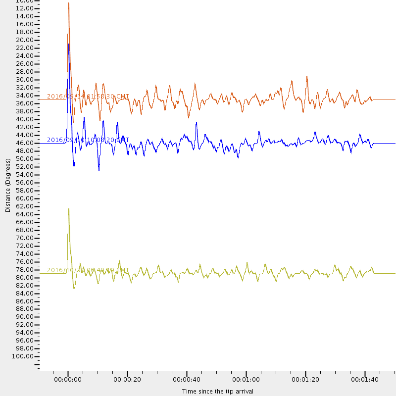
Events Used in the Stack
(3 events)| Radial Match | Distance | Baz | FERegion | Time | Lat/Lon | Depth | Magnitude |
| 93.90933 | 78.8 deg | 44.634 deg | Central Italy | 2016/10/30 06:40:19 GMT | (42.9, 13.1) | 10 km | 6.6 MWW, 6.6 MWR |
| 91.08245 | 45.9 deg | 151.206 deg | Northern Peru | 2016/09/10 10:08:20 GMT | (-5.6, -77.0) | 114 km | 6.0 MB |
| 84.47419 | 34.8 deg | 141.077 deg | Northern Colombia | 2016/09/14 01:58:30 GMT | (7.3, -76.1) | 10 km | 5.9 MWP |
Losers
(7 events)| Radial Match | Distance | Baz | FERegion | Time | Lat/Lon | Depth | Magnitude | Reason |
| 72.66934 | 75.2 deg | 157.928 deg | Chile-Argentina Border Region | 2016/11/04 16:20:43 GMT | (-35.1, -71.0) | 91 km | 6.4 MWP, 6.4 MWW | |
| 54.55905 | 89.4 deg | 250.28 deg | Tonga Islands | 2016/10/26 05:19:50 GMT | (-15.5, -174.9) | 10 km | 6.1 MWW, 6.1 MWC | |
| 45.039455 | 38.2 deg | 114.073 deg | Leeward Islands | 2016/10/18 22:08:14 GMT | (15.2, -61.5) | 143 km | 5.6 MWW, 5.6 MWB | |
| 40.200153 | 81.4 deg | 47.167 deg | Tyrrhenian Sea | 2016/10/28 20:02:48 GMT | (39.3, 13.5) | 448 km | 5.8 MWW, 5.8 MWB | |
| 38.81462 | 78.8 deg | 44.664 deg | Central Italy | 2016/10/26 17:10:37 GMT | (42.9, 13.0) | 10 km | 5.5 MWW | |
| 35.38075 | 80.4 deg | 318.235 deg | East Of Kuril Islands | 2016/10/23 20:25:26 GMT | (44.0, 148.2) | 30 km | 5.8 MB | |
| 34.482536 | 91.1 deg | 248.356 deg | Tonga Islands | 2016/09/24 21:07:13 GMT | (-18.1, -175.0) | 179 km | 6.3 MO |

