You are here: Home > Network List > 1E - GSC-BCOGC Induced Seismicity Study Stations List
> Station MONT6 Z > Earthquake Result Viewer
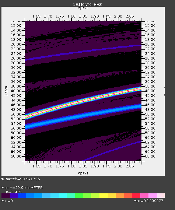
MONT6 Z - Earthquake Result Viewer
| Earthquake location: |
Solomon Islands |
| Earthquake latitude/longitude: |
-8.5/161.0 |
| Earthquake time(UTC): |
2019/02/07 (038) 01:41:34 GMT |
| Earthquake Depth: |
66 km |
| Earthquake Magnitude: |
5.5 mb |
| Earthquake Catalog/Contributor: |
NEIC PDE/us |
|
| Network: |
1E GSC-BCOGC Induced Seismicity Study |
| Station: |
MONT6 Z |
| Lat/Lon: |
56.11 N/121.02 W |
| Elevation: |
650 m |
|
| Distance: |
90.4 deg |
| Az: |
33.23 deg |
| Baz: |
255.406 deg |
| Ray Param: |
0.041668005 |
| Estimated Moho Depth: |
42.0 km |
| Estimated Crust Vp/Vs: |
1.93 |
| Assumed Crust Vp: |
6.291 km/s |
| Estimated Crust Vs: |
3.251 km/s |
| Estimated Crust Poisson's Ratio: |
0.32 |
|
| Radial Match: |
99.941795 % |
| Radial Bump: |
23 |
| Transverse Match: |
99.93797 % |
| Transverse Bump: |
22 |
| SOD ConfigId: |
13570011 |
| Insert Time: |
2019-05-02 12:21:21.697 +0000 |
| GWidth: |
2.5 |
| Max Bumps: |
400 |
| Tol: |
0.001 |
|

Signal To Noise
| Channel | StoN | STA | LTA |
| 1E:MONT6: :HHZ:20190207T01:53:56.839973Z | 4.6023088 | 2.5432024E-5 | 5.5259275E-6 |
| 1E:MONT6: :HHN:20190207T01:53:56.839973Z | 0.9768838 | 1.0625034E-8 | 1.0876456E-8 |
| 1E:MONT6: :HHE:20190207T01:53:56.839973Z | 4.594827 | 3.7665814E-5 | 8.197439E-6 |
| Arrivals |
| Ps | 6.4 SECOND |
| PpPs | 19 SECOND |
| PsPs/PpSs | 26 SECOND |


