
Station 1E MONT6 - Z
Network: 1E - GSC-BCOGC Induced Seismicity Study
Nearby stations (2 deg radius)
| Station | Name | (Lat, Lon) | Start / End | Elevation |
| MONT6 | Z | (56.11, -121.02) | 2018-10-03 / 2021-10-01 | 650 m |
| Crust2 Type: | Q3,orogen/43km no ice, Appalachians, 3 km seds. |
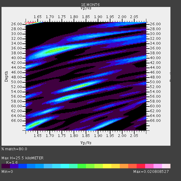
| Thickness Estimate: | 26 km |
| Thickness StdDev: | 15 km |
| Vp/Vs Estimate: | 1.60 |
| Vp/Vs StdDev: | 0.13 |
| Vs Estimate: | 3.932 km/s |
| Poisson's Ratio: | 0.18 |
| Peak Value: | 0.02 |
| Assumed Vp: | 6.291 km/s |
| Ps Weight: | 0.33333334 |
| PpPs Weight: | 0.33333334 |
| PsPs Weight: | 0.33333328 |
| Residual Complexity: | 0.939 |
| Nearby stations H: | +- |
| (2.0 deg) Vp/Vs: | +- |
5 with match > 90% ( 22.727272 %) and 9 with match > 80% ( 40.909092 %) out of 22.
Download stack as xyz text file.
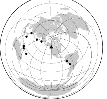
Azimuth Distribution of Events:
Prior Results for this Station
| Study | Thickness | Vp/Vs | Vp | Vs | Poissons Ratio | Extra |
| EARS | 26 km | 1.60 | 6.291 km/s | 3.932 km/s | 0.18 | |
| Crust2.0 | 43 km | 1.76 | 6.291 km/s | 3.577 km/s | 0.26 | Q3,orogen/43km no ice, Appalachians, 3 km seds. |
| Global Maxima | 26 km | 1.60 | 6.291 km/s | 3.932 km/s | 0.18 | amp=0.020808527 |
| Local Maxima 1 | 52 km | 1.83 | 6.291 km/s | 3.447 km/s | 0.29 | amp=0.01198166 |
| Local Maxima 2 | 36 km | 1.73 | 6.291 km/s | 3.647 km/s | 0.25 | amp=0.011141406 |
| Local Maxima 3 | 68 km | 1.63 | 6.291 km/s | 3.853 km/s | 0.20 | amp=0.010603038 |
| Local Maxima 4 | 68 km | 1.91 | 6.291 km/s | 3.285 km/s | 0.31 | amp=0.00659025 |
| Predicted Arrivals for vertical incidence (zero ray parameter) | |
| Ps | 2.43 SECOND |
| PpPs | 10.54 SECOND |
| PsPs/PpSs | 12.97 SECOND |
Events Processed for this Station
Download zip of receiver functions as SAC
Plot maxima for each earthquake.
Events Used in the Stack
(9 events)| Radial Match | Distance | Baz | FERegion | Time | Lat/Lon | Depth | Magnitude |
| 99.941795 | 90.4 deg | 255.406 deg | Solomon Islands | 2019/02/07 01:41:34 GMT | (-8.5, 161.0) | 66 km | 5.5 mb |
| 98.74176 | 57.5 deg | 297.905 deg | Off Coast Of Hokkaido, Japan | 2019/03/02 03:22:52 GMT | (41.9, 146.9) | 10 km | 6.0 Mww |
| 97.636734 | 85.5 deg | 305.355 deg | Taiwan | 2019/04/03 01:52:56 GMT | (23.0, 120.9) | 10 km | 5.4 Mww |
| 95.77327 | 96.8 deg | 272.734 deg | New Guinea, Papua New Guinea | 2019/03/06 18:47:25 GMT | (-4.1, 142.9) | 129 km | 5.6 Mww |
| 93.08673 | 94.9 deg | 293.073 deg | Mindanao, Philippines | 2019/03/06 00:13:00 GMT | (8.5, 126.9) | 16 km | 5.8 Mww |
| 89.047165 | 97.2 deg | 268.197 deg | Eastern New Guinea Reg., P.N.G. | 2019/05/06 21:19:37 GMT | (-7.0, 146.4) | 146 km | 7.1 mww |
| 86.0582 | 40.2 deg | 300.385 deg | Komandorskiye Ostrova Region | 2018/12/20 17:01:56 GMT | (54.8, 164.8) | 33 km | 7.3 Mi |
| 84.5715 | 72.3 deg | 131.612 deg | Northern Peru | 2019/05/26 07:41:13 GMT | (-5.9, -75.3) | 105 km | 7.5 Mi |
| 81.02356 | 87.1 deg | 132.172 deg | Northern Chile | 2018/11/01 22:19:51 GMT | (-19.6, -69.3) | 102 km | 6.2 Mww |
Losers
(13 events)| Radial Match | Distance | Baz | FERegion | Time | Lat/Lon | Depth | Magnitude | Reason |
| 99.95753 | 68.2 deg | 131.629 deg | Peru-Ecuador Border Region | 2019/02/22 10:17:22 GMT | (-2.2, -77.0) | 132 km | 7.5 mww | |
| 99.89806 | 82.3 deg | 130.74 deg | Central Peru | 2019/03/01 08:50:41 GMT | (-14.7, -70.1) | 257 km | 7.0 mww | |
| 98.98299 | 62.5 deg | 127.703 deg | Colombia | 2019/03/23 19:21:16 GMT | (4.6, -76.3) | 113 km | 6.1 Mww | |
| 98.57708 | 44.9 deg | 48.369 deg | Reykjanes Ridge | 2019/03/10 18:04:59 GMT | (58.3, -32.0) | 10 km | 5.9 Mww | |
| 97.09568 | 44.9 deg | 48.059 deg | Reykjanes Ridge | 2019/03/10 17:58:44 GMT | (58.5, -31.7) | 10 km | 5.5 Mww | |
| 95.15776 | 67.3 deg | 134.534 deg | Near Coast Of Ecuador | 2019/02/04 17:45:47 GMT | (-2.4, -79.9) | 70 km | 5.8 Mww | |
| 91.07342 | 93.7 deg | 295.009 deg | Leyte, Philippines | 2019/04/01 02:16:53 GMT | (10.6, 125.9) | 58 km | 5.5 Mww | |
| 90.459305 | 88.9 deg | 227.62 deg | Tonga Islands | 2019/03/26 21:54:06 GMT | (-21.4, -173.4) | 10 km | 5.3 Mww | |
| 75.817184 | 75.9 deg | 129.135 deg | Western Brazil | 2019/01/05 19:25:38 GMT | (-8.1, -71.6) | 575 km | 6.8 Mww | |
| 71.103966 | 53.3 deg | 302.913 deg | Northwest Of Kuril Islands | 2018/11/02 11:01:15 GMT | (47.8, 146.7) | 432 km | 5.9 Mww | |
| 68.10133 | 88.2 deg | 233.791 deg | Fiji Islands Region | 2018/11/18 20:25:45 GMT | (-17.9, -178.9) | 534 km | 6.7 Mww | |
| 66.98992 | 46.8 deg | 140.352 deg | Near Coast Of Chiapas, Mexico | 2019/02/01 16:14:13 GMT | (14.8, -92.3) | 68 km | 6.6 Mww | |
| 25.551546 | 89.7 deg | 249.977 deg | Santa Cruz Islands | 2019/01/26 02:07:23 GMT | (-10.9, 165.9) | 52 km | 5.7 Mww |

