You are here: Home > Network List > C1 - Red Sismologica Nacional Stations List
> Station BI04 Isla Mocha > Earthquake Result Viewer
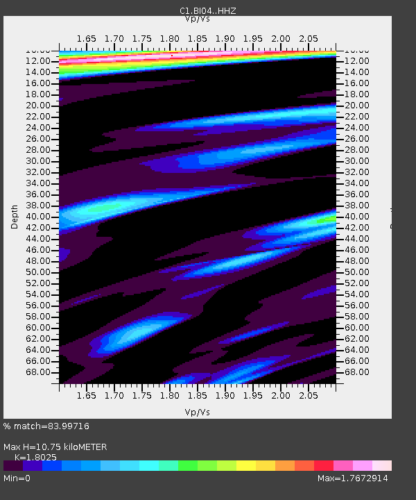
BI04 Isla Mocha - Earthquake Result Viewer
| Earthquake location: |
Peru-Ecuador Border Region |
| Earthquake latitude/longitude: |
-2.2/-77.0 |
| Earthquake time(UTC): |
2019/02/22 (053) 10:17:22 GMT |
| Earthquake Depth: |
132 km |
| Earthquake Magnitude: |
7.5 mww |
| Earthquake Catalog/Contributor: |
NEIC PDE/us |
|
| Network: |
C1 Red Sismologica Nacional |
| Station: |
BI04 Isla Mocha |
| Lat/Lon: |
38.41 S/73.89 W |
| Elevation: |
41 m |
|
| Distance: |
36.2 deg |
| Az: |
175.821 deg |
| Baz: |
354.682 deg |
| Ray Param: |
0.07638336 |
| Estimated Moho Depth: |
10.75 km |
| Estimated Crust Vp/Vs: |
1.80 |
| Assumed Crust Vp: |
6.597 km/s |
| Estimated Crust Vs: |
3.66 km/s |
| Estimated Crust Poisson's Ratio: |
0.28 |
|
| Radial Match: |
83.99716 % |
| Radial Bump: |
321 |
| Transverse Match: |
77.4529 % |
| Transverse Bump: |
400 |
| SOD ConfigId: |
13570011 |
| Insert Time: |
2019-05-02 13:54:16.549 +0000 |
| GWidth: |
2.5 |
| Max Bumps: |
400 |
| Tol: |
0.001 |
|

Signal To Noise
| Channel | StoN | STA | LTA |
| C1:BI04: :HHZ:20190222T10:23:41.619991Z | 48.032375 | 4.9247927E-5 | 1.0253069E-6 |
| C1:BI04: :HHN:20190222T10:23:41.619991Z | 22.21749 | 2.7712409E-5 | 1.247324E-6 |
| C1:BI04: :HHE:20190222T10:23:41.619991Z | 4.606718 | 5.9170397E-6 | 1.2844372E-6 |
| Arrivals |
| Ps | 1.4 SECOND |
| PpPs | 4.2 SECOND |
| PsPs/PpSs | 5.6 SECOND |


