You are here: Home > Network List > JP - Japan Meteorological Agency Seismic Network Stations List
> Station JEM Erimo > Earthquake Result Viewer
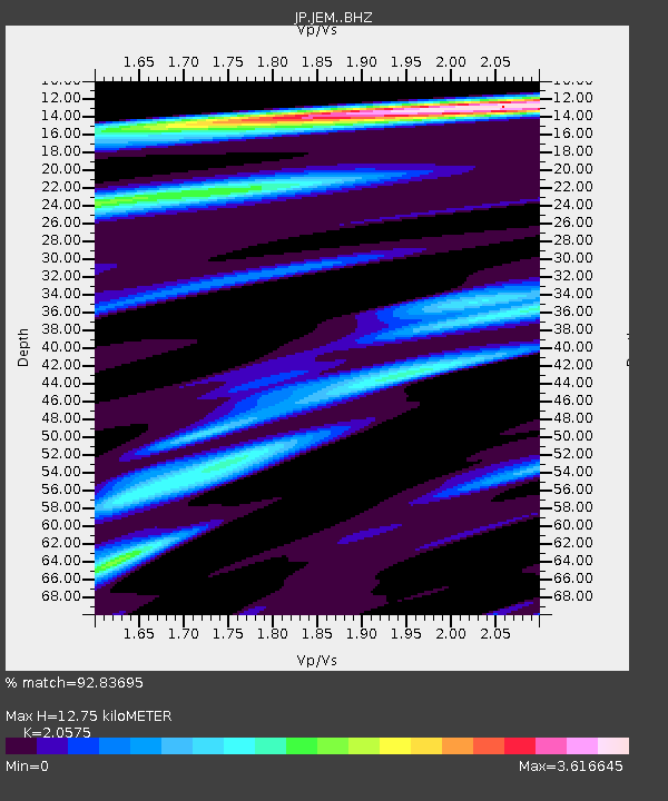
JEM Erimo - Earthquake Result Viewer
| Earthquake location: |
Eastern New Guinea Reg., P.N.G. |
| Earthquake latitude/longitude: |
-7.0/146.4 |
| Earthquake time(UTC): |
2019/05/06 (126) 21:19:37 GMT |
| Earthquake Depth: |
146 km |
| Earthquake Magnitude: |
7.1 mww |
| Earthquake Catalog/Contributor: |
NEIC PDE/us |
|
| Network: |
JP Japan Meteorological Agency Seismic Network |
| Station: |
JEM Erimo |
| Lat/Lon: |
42.02 N/143.15 E |
| Elevation: |
40 m |
|
| Distance: |
48.8 deg |
| Az: |
356.739 deg |
| Baz: |
175.654 deg |
| Ray Param: |
0.0685711 |
| Estimated Moho Depth: |
12.75 km |
| Estimated Crust Vp/Vs: |
2.06 |
| Assumed Crust Vp: |
6.461 km/s |
| Estimated Crust Vs: |
3.14 km/s |
| Estimated Crust Poisson's Ratio: |
0.35 |
|
| Radial Match: |
92.83695 % |
| Radial Bump: |
400 |
| Transverse Match: |
88.28825 % |
| Transverse Bump: |
400 |
| SOD ConfigId: |
18369291 |
| Insert Time: |
2019-05-20 21:22:52.248 +0000 |
| GWidth: |
2.5 |
| Max Bumps: |
400 |
| Tol: |
0.001 |
|

Signal To Noise
| Channel | StoN | STA | LTA |
| JP:JEM: :BHZ:20190506T21:27:54.149992Z | 50.1325 | 6.6722664E-6 | 1.3309263E-7 |
| JP:JEM: :BHN:20190506T21:27:54.149992Z | 32.950195 | 7.292525E-6 | 2.2131964E-7 |
| JP:JEM: :BHE:20190506T21:27:54.149992Z | 7.395492 | 1.725195E-6 | 2.3327657E-7 |
| Arrivals |
| Ps | 2.2 SECOND |
| PpPs | 5.7 SECOND |
| PsPs/PpSs | 7.9 SECOND |


