You are here: Home > Network List > TA - USArray Transportable Network (new EarthScope stations) Stations List
> Station W12A Cal Nev Ari, NV, USA > Earthquake Result Viewer
W12A Cal Nev Ari, NV, USA - Earthquake Result Viewer
| Earthquake location: |
Northern Chile |
| Earthquake latitude/longitude: |
-22.2/-69.9 |
| Earthquake time(UTC): |
2007/11/14 (318) 15:40:50 GMT |
| Earthquake Depth: |
40 km |
| Earthquake Magnitude: |
6.7 MB, 7.4 MS, 7.7 MW, 7.4 ME |
| Earthquake Catalog/Contributor: |
WHDF/NEIC |
|
| Network: |
TA USArray Transportable Network (new EarthScope stations) |
| Station: |
W12A Cal Nev Ari, NV, USA |
| Lat/Lon: |
35.30 N/114.87 W |
| Elevation: |
774 m |
|
| Distance: |
71.4 deg |
| Az: |
322.399 deg |
| Baz: |
136.284 deg |
| Ray Param: |
0.054305222 |
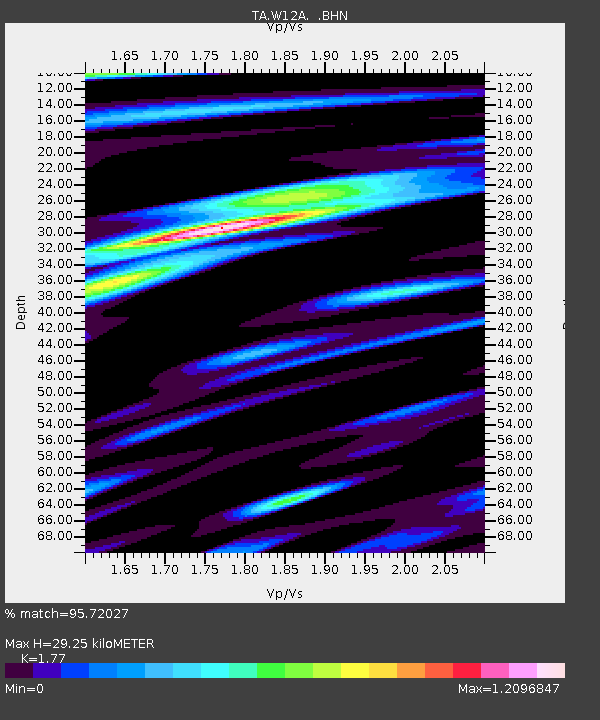
| Estimated Moho Depth: |
29.25 km |
| Estimated Crust Vp/Vs: |
1.77 |
| Assumed Crust Vp: |
6.276 km/s |
| Estimated Crust Vs: |
3.546 km/s |
| Estimated Crust Poisson's Ratio: |
0.27 |
|
| Radial Match: |
95.72027 % |
| Radial Bump: |
400 |
| Transverse Match: |
89.34431 % |
| Transverse Bump: |
400 |
| SOD ConfigId: |
2564 |
| Insert Time: |
2010-03-06 22:12:58.859 +0000 |
| GWidth: |
2.5 |
| Max Bumps: |
400 |
| Tol: |
0.001 |
|
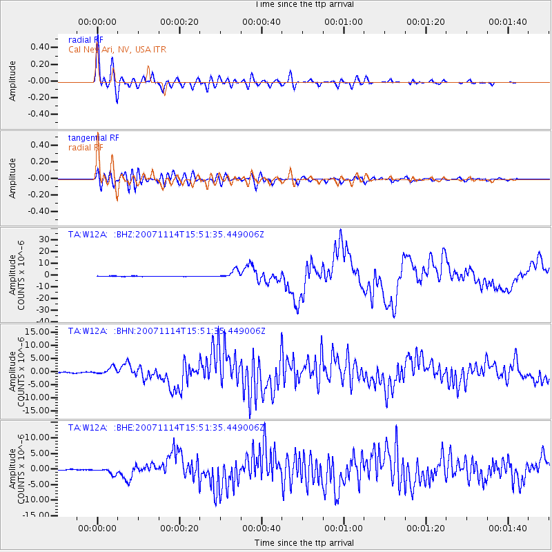
Signal To Noise
| Channel | StoN | STA | LTA |
| TA:W12A: :BHN:20071114T15:51:35.449006Z | 8.68019 | 1.3576685E-6 | 1.5640998E-7 |
| TA:W12A: :BHE:20071114T15:51:35.449006Z | 7.7091203 | 1.0279092E-6 | 1.3333678E-7 |
| TA:W12A: :BHZ:20071114T15:51:35.449006Z | 23.252502 | 3.6385302E-6 | 1.5647908E-7 |
| Arrivals |
| Ps | 3.7 SECOND |
| PpPs | 12 SECOND |
| PsPs/PpSs | 16 SECOND |


