
Station TA W12A - Cal Nev Ari, NV, USA
Network: TA - USArray Transportable Network (new EarthScope stations)
Nearby stations (2 deg radius)
| Station | Name | (Lat, Lon) | Start / End | Elevation |
| W12A | Cal Nev Ari, NV, USA | (35.30, -114.87) | 2006-03-25 / 2499-01-01 | 0.8 km |
| Crust2 Type: | M5,extended crust, 0.5 km seds. |
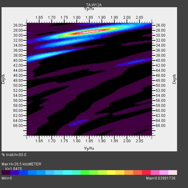
| Thickness Estimate: | 28 km |
| Thickness StdDev: | 0.2 km |
| Vp/Vs Estimate: | 1.85 |
| Vp/Vs StdDev: | 0.01 |
| Vs Estimate: | 3.397 km/s |
| Poisson's Ratio: | 0.29 |
| Peak Value: | 0.04 |
| Assumed Vp: | 6.276 km/s |
| Ps Weight: | 0.33333334 |
| PpPs Weight: | 0.33333334 |
| PsPs Weight: | 0.33333328 |
| Residual Complexity: | 0.281 |
| Nearby stations H: | +- |
| (2.0 deg) Vp/Vs: | +- |
21 with match > 90% ( 33.870968 %) and 62 with match > 80% ( 100.0 %) out of 62.
Download stack as xyz text file.
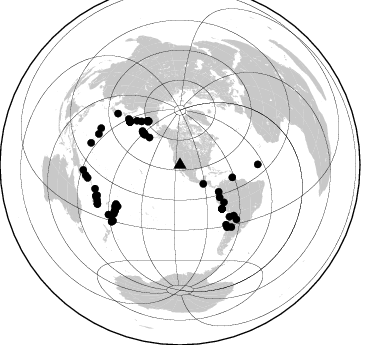
Azimuth Distribution of Events:
Prior Results for this Station
| Study | Thickness | Vp/Vs | Vp | Vs | Poissons Ratio | Extra |
| EARS | 28 km | 1.85 | 6.276 km/s | 3.397 km/s | 0.29 | |
| Crust2.0 | 31 km | 1.78 | 6.276 km/s | 3.529 km/s | 0.27 | M5,extended crust, 0.5 km seds. |
| Global Maxima | 28 km | 1.85 | 6.276 km/s | 3.397 km/s | 0.29 | amp=0.03981736 |
| Local Maxima 1 | 38 km | 1.67 | 6.276 km/s | 3.758 km/s | 0.22 | amp=0.014164908 |
| Local Maxima 2 | 28 km | 1.87 | 6.276 km/s | 3.361 km/s | 0.30 | amp=0.00560705 |
| Local Maxima 3 | 40 km | 2.04 | 6.276 km/s | 3.076 km/s | 0.34 | amp=0.0046970816 |
| Local Maxima 4 | 64 km | 1.81 | 6.276 km/s | 3.467 km/s | 0.28 | amp=0.0037089628 |
| Predicted Arrivals for vertical incidence (zero ray parameter) | |
| Ps | 3.85 SECOND |
| PpPs | 12.93 SECOND |
| PsPs/PpSs | 16.78 SECOND |
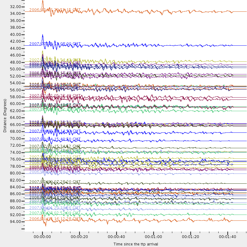
Events Processed for this Station
Download zip of receiver functions as SAC
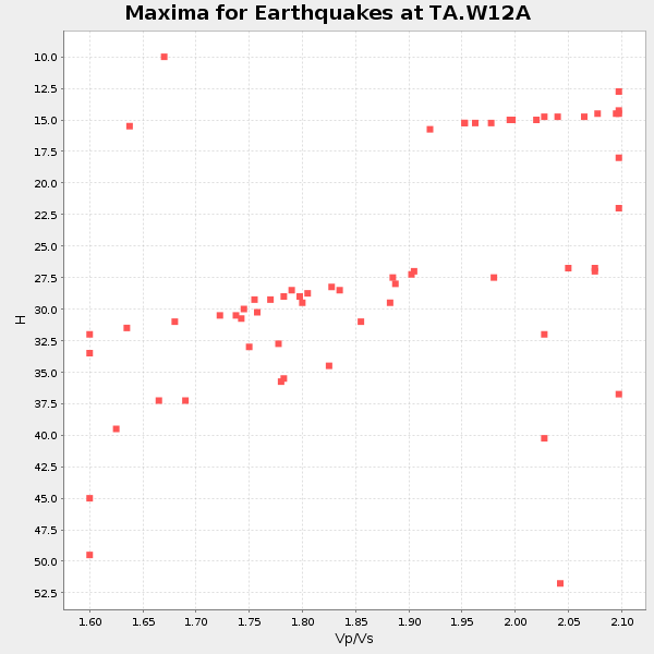
Plot maxima for each earthquake.
Events Used in the Stack
(62 events)| Radial Match | Distance | Baz | FERegion | Time | Lat/Lon | Depth | Magnitude |
| 97.98647 | 88.1 deg | 254.473 deg | Santa Cruz Islands | 2007/09/02 01:05:18 GMT | (-11.6, 165.8) | 35 km | 5.9 MB, 7.3 MS, 7.2 MW, 6.9 ME |
| 97.53211 | 46.9 deg | 124.824 deg | Near West Coast Of Colombia | 2007/09/10 01:49:14 GMT | (3.0, -78.0) | 31 km | 6.1 MB, 6.7 MS, 6.8 MW |
| 97.365105 | 66.5 deg | 311.287 deg | Kuril Islands | 2006/11/15 11:14:13 GMT | (46.6, 153.3) | 10 km | 6.5 MB, 7.8 MS, 8.3 MW, 7.9 MW |
| 96.074425 | 65.9 deg | 310.519 deg | East Of Kuril Islands | 2007/01/13 04:23:21 GMT | (46.2, 154.5) | 10 km | 7.3 MB, 8.2 MS, 8.1 MW, 7.9 MW |
| 95.72027 | 71.4 deg | 136.284 deg | Northern Chile | 2007/11/14 15:40:50 GMT | (-22.2, -69.9) | 40 km | 6.7 MB, 7.4 MS, 7.7 MW, 7.4 ME |
| 95.10403 | 77.0 deg | 237.544 deg | Tonga Islands | 2007/08/26 12:37:31 GMT | (-17.5, -174.3) | 127 km | 5.9 MB, 6.1 MW |
| 94.65243 | 60.5 deg | 136.164 deg | Near Coast Of Peru | 2007/08/15 23:40:57 GMT | (-13.4, -76.6) | 39 km | 6.7 MB, 7.9 MS, 8.0 MW, 7.5 ME |
| 94.43056 | 74.8 deg | 236.599 deg | Samoa Islands Region | 2006/09/28 06:22:09 GMT | (-16.6, -172.0) | 28 km | 6.5 MB, 6.6 MS, 6.9 MW, 6.7 MW |
| 94.42976 | 54.2 deg | 323.938 deg | Eastern Siberia, Russia | 2006/04/20 23:25:02 GMT | (60.9, 167.1) | 22 km | 6.8 MB, 7.6 MS, 7.6 MW, 7.3 MW |
| 94.33665 | 93.3 deg | 262.023 deg | Solomon Islands | 2007/04/01 20:39:56 GMT | (-8.5, 157.0) | 10 km | 6.8 MB, 7.9 MS, 8.1 MW, 7.7 ME |
| 93.8379 | 51.0 deg | 129.249 deg | Peru-Ecuador Border Region | 2007/11/16 03:13:00 GMT | (-2.3, -77.8) | 123 km | 6.3 MB, 6.8 MW, 6.7 MW |
| 93.540596 | 85.0 deg | 233.361 deg | South Of Fiji Islands | 2007/12/09 07:28:20 GMT | (-26.0, -177.5) | 152 km | 7.0 MB, 7.8 MW, 7.7 MW |
| 93.310684 | 75.0 deg | 238.69 deg | Tonga Islands | 2006/07/07 07:26:12 GMT | (-15.2, -173.6) | 35 km | 5.7 MB, 5.9 MS, 6.0 MW, 6.0 MW |
| 93.27289 | 80.7 deg | 309.491 deg | Near West Coast Of Honshu, Japan | 2007/07/16 01:13:22 GMT | (37.5, 138.4) | 12 km | 6.5 MB, 6.4 MS, 6.6 MW, 6.5 MW |
| 92.35096 | 89.0 deg | 250.181 deg | Vanuatu Islands | 2007/08/01 17:08:51 GMT | (-15.6, 167.7) | 120 km | 6.2 MB, 7.2 MW, 7.2 MW |
| 91.890526 | 41.0 deg | 311.701 deg | Fox Islands, Aleutian Islands | 2007/07/15 13:08:00 GMT | (52.5, -168.0) | 10 km | 5.8 MB, 5.9 MS, 6.1 MW, 6.0 MW |
| 91.64048 | 88.2 deg | 249.816 deg | Vanuatu Islands | 2007/07/15 09:27:34 GMT | (-15.4, 168.6) | 8.0 km | 6.0 MB, 5.8 MS, 6.1 MW, 6.0 MW |
| 91.25226 | 61.8 deg | 315.682 deg | Kamchatka Peninsula, Russia | 2007/05/30 20:22:12 GMT | (52.1, 157.3) | 116 km | 6.4 MB, 6.4 MW, 6.4 MW |
| 90.792244 | 87.1 deg | 294.872 deg | Volcano Islands, Japan Region | 2007/09/28 13:38:59 GMT | (22.0, 142.7) | 276 km | 6.7 MB, 7.4 MW, 7.4 MW |
| 90.77537 | 66.6 deg | 311.177 deg | Kuril Islands | 2006/10/01 09:06:02 GMT | (46.5, 153.2) | 19 km | 6.1 MB, 6.4 MS, 6.6 MW, 6.5 MW |
| 90.11944 | 60.5 deg | 136.279 deg | Near Coast Of Peru | 2006/10/20 10:48:56 GMT | (-13.5, -76.7) | 23 km | 5.9 MB, 6.6 MS, 6.7 MW, 6.6 MW |
| 89.8394 | 91.6 deg | 283.891 deg | South Of Mariana Islands | 2007/09/30 02:08:30 GMT | (10.5, 145.7) | 14 km | 6.4 MB, 7.1 MS, 6.9 MW, 6.9 MW |
| 89.68042 | 68.9 deg | 311.697 deg | Kuril Islands | 2007/09/03 16:14:53 GMT | (45.8, 150.1) | 94 km | 6.3 MB, 6.2 MW, 6.2 ME |
| 89.565254 | 86.8 deg | 235.326 deg | South Of Fiji Islands | 2007/10/16 21:05:43 GMT | (-25.8, 179.5) | 509 km | 6.2 MB, 6.6 MW, 6.5 MW |
| 89.467865 | 87.9 deg | 230.904 deg | Kermadec Islands, New Zealand | 2007/01/31 03:15:52 GMT | (-29.8, -178.0) | 34 km | 6.1 MB, 6.3 MS, 6.5 MW, 6.4 MW |
| 89.019325 | 50.2 deg | 311.328 deg | Rat Islands, Aleutian Islands | 2006/06/14 04:18:42 GMT | (51.8, 177.1) | 14 km | 5.9 MB, 6.4 MS, 6.4 MW, 6.4 MW |
| 88.50808 | 54.1 deg | 323.337 deg | Eastern Siberia, Russia | 2006/04/29 16:58:06 GMT | (60.5, 167.5) | 11 km | 6.4 MB, 6.6 MS, 6.6 MW, 6.4 MW |
| 88.490135 | 46.1 deg | 310.825 deg | Andreanof Islands, Aleutian Is. | 2007/07/13 21:54:43 GMT | (51.8, -176.3) | 35 km | 5.7 MB, 5.6 MS, 6.0 MW, 5.9 MW |
| 88.09955 | 78.1 deg | 133.872 deg | Santiago Del Estero Prov., Arg. | 2006/11/13 01:26:34 GMT | (-26.0, -63.2) | 552 km | 6.3 MB, 6.8 MW, 6.8 MW |
| 87.97559 | 53.8 deg | 103.308 deg | Trinidad | 2006/09/29 13:08:26 GMT | (10.9, -61.8) | 53 km | 5.9 MB, 5.4 MS, 6.1 MW, 6.0 MW |
| 87.33195 | 48.0 deg | 310.217 deg | Andreanof Islands, Aleutian Is. | 2006/07/08 20:40:00 GMT | (51.2, -179.3) | 22 km | 6.2 MB, 6.4 MS, 6.6 MW, 6.6 MW |
| 87.30493 | 73.7 deg | 133.109 deg | Jujuy Province, Argentina | 2007/07/21 15:34:52 GMT | (-22.2, -65.8) | 290 km | 5.8 MB, 6.4 MW, 6.3 MW |
| 87.105156 | 66.0 deg | 310.477 deg | East Of Kuril Islands | 2006/12/07 19:10:21 GMT | (46.2, 154.4) | 16 km | 6.3 MB, 6.1 MS, 6.3 MW, 6.3 MW |
| 87.02078 | 53.9 deg | 324.393 deg | Eastern Siberia, Russia | 2006/04/21 11:14:15 GMT | (61.4, 167.5) | 12 km | 5.8 MB, 5.8 MS, 6.1 MW, 6.1 MW |
| 86.7504 | 86.9 deg | 290.868 deg | Mariana Islands | 2007/10/31 03:30:17 GMT | (18.9, 145.4) | 223 km | 6.2 MB, 7.2 MW, 7.2 MW |
| 86.66914 | 47.5 deg | 311.458 deg | Andreanof Islands, Aleutian Is. | 2008/03/22 21:24:11 GMT | (52.2, -178.7) | 132 km | 5.8 MB, 6.2 MW, 6.1 MW |
| 85.71965 | 50.6 deg | 312.023 deg | Rat Islands, Aleutian Islands | 2006/06/27 02:39:35 GMT | (52.2, 176.2) | 34 km | 5.6 MB, 6.0 MS, 6.2 MW, 6.2 MW |
| 85.53806 | 78.9 deg | 234.961 deg | Tonga Islands | 2006/05/17 03:06:16 GMT | (-20.6, -173.9) | 10 km | 5.8 MB, 5.8 MS, 6.0 MW, 5.8 MW |
| 85.52725 | 57.5 deg | 130.303 deg | Peru-Brazil Border Region | 2007/07/12 05:23:49 GMT | (-7.9, -74.4) | 152 km | 5.9 MB, 6.1 MW, 6.0 MW |
| 85.490166 | 96.8 deg | 267.032 deg | New Britain Region, P.N.G. | 2006/11/13 16:12:28 GMT | (-6.4, 151.2) | 11 km | 6.1 MB, 5.9 MS, 6.2 MW, 6.1 MW |
| 85.36241 | 95.0 deg | 263.795 deg | Solomon Islands | 2007/06/28 02:52:09 GMT | (-8.0, 154.6) | 10 km | 6.3 MB, 6.7 MS, 6.7 MW, 6.7 MW |
| 85.05104 | 77.9 deg | 142.906 deg | Near Coast Of Central Chile | 2006/10/12 18:05:58 GMT | (-31.3, -71.3) | 46 km | 5.8 MB, 6.1 MS, 6.4 MW, 6.3 MW |
| 84.97015 | 78.9 deg | 235.059 deg | Tonga Islands | 2006/05/04 11:25:26 GMT | (-20.6, -174.0) | 11 km | 5.7 MB, 5.8 MS, 6.0 MW, 5.8 MW |
| 84.86573 | 60.7 deg | 136.307 deg | Near Coast Of Peru | 2007/08/17 13:18:13 GMT | (-13.6, -76.6) | 48 km | 5.6 MB, 5.6 MS, 5.9 MW |
| 84.7297 | 89.8 deg | 249.609 deg | Vanuatu Islands | 2008/03/12 11:23:34 GMT | (-16.6, 167.3) | 13 km | 5.8 MB, 6.4 MS, 6.4 MW, 6.4 MW |
| 84.299675 | 66.7 deg | 311.137 deg | Kuril Islands | 2008/03/03 09:31:02 GMT | (46.4, 153.2) | 10 km | 6.2 MB, 6.5 MS, 6.5 MW, 6.5 MW |
| 83.96297 | 91.1 deg | 244.9 deg | Southeast Of Loyalty Islands | 2007/09/27 19:57:44 GMT | (-21.1, 169.3) | 9.0 km | 6.2 MB, 6.3 MS, 6.1 MW, 6.1 MW |
| 83.66382 | 58.2 deg | 318.469 deg | Near East Coast Of Kamchatka | 2006/08/17 11:11:35 GMT | (55.6, 161.7) | 55 km | 6.1 MB, 5.7 MW, 5.7 MW |
| 83.37833 | 81.8 deg | 233.716 deg | Tonga Islands Region | 2006/10/08 13:50:24 GMT | (-23.6, -175.3) | 10 km | 5.6 MB, 5.6 MS, 5.8 MW, 5.7 MW |
| 83.2218 | 90.0 deg | 246.824 deg | Vanuatu Islands | 2006/10/03 18:03:14 GMT | (-18.9, 169.0) | 171 km | 5.9 MB, 6.3 MW, 6.3 MW |
| 83.15062 | 87.0 deg | 230.32 deg | Kermadec Islands Region | 2006/03/31 13:21:00 GMT | (-29.6, -176.8) | 17 km | 5.9 MB, 6.7 MS, 6.5 MW, 6.5 MW |
| 82.70163 | 54.8 deg | 323.856 deg | Eastern Siberia, Russia | 2006/05/09 11:02:22 GMT | (60.8, 165.9) | 10 km | 5.6 MB, 5.5 MS, 5.8 MW, 5.7 MW |
| 82.54553 | 80.3 deg | 140.271 deg | San Juan Province, Argentina | 2006/09/17 09:34:14 GMT | (-31.7, -67.2) | 142 km | 5.7 MB, 6.2 MW, 6.2 MW |
| 82.29504 | 77.9 deg | 89.649 deg | Central Mid-Atlantic Ridge | 2006/09/30 12:47:22 GMT | (7.3, -34.7) | 10 km | 5.6 MB, 5.0 MS, 5.5 MW |
| 82.24846 | 91.1 deg | 244.775 deg | Southeast Of Loyalty Islands | 2007/09/28 01:01:48 GMT | (-21.2, 169.4) | 10 km | 5.8 MB, 6.4 MS, 6.3 MW, 6.2 MW |
| 81.79714 | 75.2 deg | 142.274 deg | Off Coast Of Central Chile | 2006/07/16 11:42:41 GMT | (-28.7, -72.5) | 10 km | 5.9 MB, 5.7 MS, 6.2 MW, 6.2 MW |
| 81.51913 | 30.1 deg | 128.95 deg | Near Coast Of Guatemala | 2006/12/03 20:52:15 GMT | (14.0, -91.2) | 61 km | 5.8 MB, 5.9 MW, 5.9 MW |
| 81.03834 | 66.2 deg | 310.391 deg | East Of Kuril Islands | 2007/10/25 13:50:02 GMT | (46.0, 154.2) | 10 km | 6.0 MB, 5.7 MS, 6.1 MW, 5.9 MW |
| 81.021 | 54.9 deg | 323.561 deg | Eastern Siberia, Russia | 2006/04/21 04:32:43 GMT | (60.5, 165.8) | 9.0 km | 6.3 MB, 5.6 MS, 6.1 MW, 6.1 ME |
| 80.778175 | 60.7 deg | 136.336 deg | Near Coast Of Peru | 2007/08/19 01:22:40 GMT | (-13.6, -76.6) | 26 km | 5.9 MB, 5.4 MS, 5.8 MW, 5.5 ML |
| 80.550446 | 88.6 deg | 230.379 deg | Kermadec Islands, New Zealand | 2007/05/17 19:29:10 GMT | (-30.7, -178.2) | 41 km | 5.5 MB, 5.6 MS, 6.0 MW, 5.9 MW |
| 80.13085 | 79.9 deg | 234.963 deg | Tonga Islands | 2006/11/30 11:33:17 GMT | (-21.3, -174.7) | 14 km | 5.7 MB, 6.1 MS, 6.0 MW, 6.0 MW |
Losers
(0 events)| Radial Match | Distance | Baz | FERegion | Time | Lat/Lon | Depth | Magnitude | Reason |
