You are here: Home > Network List > TA - USArray Transportable Network (new EarthScope stations) Stations List
> Station W12A Cal Nev Ari, NV, USA > Earthquake Result Viewer
W12A Cal Nev Ari, NV, USA - Earthquake Result Viewer
| Earthquake location: |
Near Coast Of Guatemala |
| Earthquake latitude/longitude: |
14.0/-91.2 |
| Earthquake time(UTC): |
2006/12/03 (337) 20:52:15 GMT |
| Earthquake Depth: |
61 km |
| Earthquake Magnitude: |
5.8 MB, 5.9 MW, 5.9 MW |
| Earthquake Catalog/Contributor: |
WHDF/NEIC |
|
| Network: |
TA USArray Transportable Network (new EarthScope stations) |
| Station: |
W12A Cal Nev Ari, NV, USA |
| Lat/Lon: |
35.30 N/114.87 W |
| Elevation: |
774 m |
|
| Distance: |
30.1 deg |
| Az: |
319.056 deg |
| Baz: |
128.95 deg |
| Ray Param: |
0.07934412 |
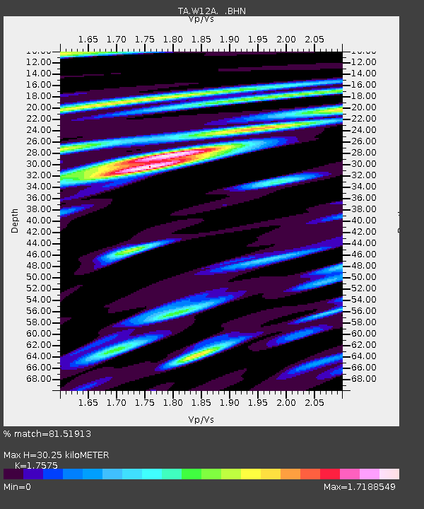
| Estimated Moho Depth: |
30.25 km |
| Estimated Crust Vp/Vs: |
1.76 |
| Assumed Crust Vp: |
6.276 km/s |
| Estimated Crust Vs: |
3.571 km/s |
| Estimated Crust Poisson's Ratio: |
0.26 |
|
| Radial Match: |
81.51913 % |
| Radial Bump: |
400 |
| Transverse Match: |
78.37712 % |
| Transverse Bump: |
400 |
| SOD ConfigId: |
2564 |
| Insert Time: |
2010-03-06 22:13:34.783 +0000 |
| GWidth: |
2.5 |
| Max Bumps: |
400 |
| Tol: |
0.001 |
|
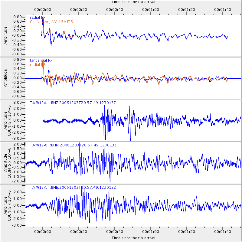
Signal To Noise
| Channel | StoN | STA | LTA |
| TA:W12A: :BHN:20061203T20:57:49.123013Z | 2.4561899 | 3.0872528E-7 | 1.2569276E-7 |
| TA:W12A: :BHE:20061203T20:57:49.123013Z | 1.6694355 | 3.4231022E-7 | 2.0504548E-7 |
| TA:W12A: :BHZ:20061203T20:57:49.123013Z | 5.5985293 | 9.55375E-7 | 1.7064748E-7 |
| Arrivals |
| Ps | 3.9 SECOND |
| PpPs | 12 SECOND |
| PsPs/PpSs | 16 SECOND |


