You are here: Home > Network List > TA - USArray Transportable Network (new EarthScope stations) Stations List
> Station W12A Cal Nev Ari, NV, USA > Earthquake Result Viewer
W12A Cal Nev Ari, NV, USA - Earthquake Result Viewer
| Earthquake location: |
Tonga Islands |
| Earthquake latitude/longitude: |
-21.3/-174.7 |
| Earthquake time(UTC): |
2006/11/30 (334) 11:33:17 GMT |
| Earthquake Depth: |
14 km |
| Earthquake Magnitude: |
5.7 MB, 6.1 MS, 6.0 MW, 6.0 MW |
| Earthquake Catalog/Contributor: |
WHDF/NEIC |
|
| Network: |
TA USArray Transportable Network (new EarthScope stations) |
| Station: |
W12A Cal Nev Ari, NV, USA |
| Lat/Lon: |
35.30 N/114.87 W |
| Elevation: |
774 m |
|
| Distance: |
79.9 deg |
| Az: |
45.904 deg |
| Baz: |
234.963 deg |
| Ray Param: |
0.048658278 |
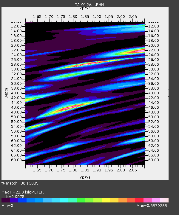
| Estimated Moho Depth: |
22.0 km |
| Estimated Crust Vp/Vs: |
2.10 |
| Assumed Crust Vp: |
6.276 km/s |
| Estimated Crust Vs: |
2.992 km/s |
| Estimated Crust Poisson's Ratio: |
0.35 |
|
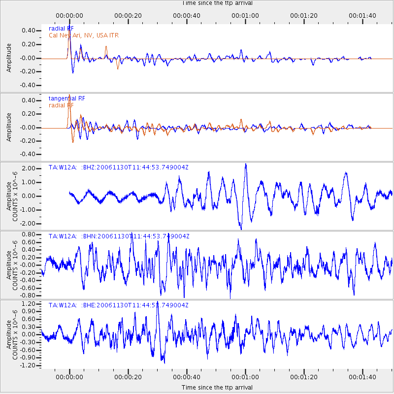
| Radial Match: |
80.13085 % |
| Radial Bump: |
400 |
| Transverse Match: |
55.20365 % |
| Transverse Bump: |
400 |
| SOD ConfigId: |
2564 |
| Insert Time: |
2010-03-06 22:13:36.081 +0000 |
| GWidth: |
2.5 |
| Max Bumps: |
400 |
| Tol: |
0.001 |
|
Signal To Noise
| Channel | StoN | STA | LTA |
| TA:W12A: :BHN:20061130T11:44:53.749004Z | 1.2249366 | 2.9228642E-7 | 2.386135E-7 |
| TA:W12A: :BHE:20061130T11:44:53.749004Z | 2.27191 | 3.2568386E-7 | 1.4335244E-7 |
| TA:W12A: :BHZ:20061130T11:44:53.749004Z | 1.9945499 | 4.848394E-7 | 2.4308213E-7 |
| Arrivals |
| Ps | 3.9 SECOND |
| PpPs | 11 SECOND |
| PsPs/PpSs | 15 SECOND |


