You are here: Home > Network List > TA - USArray Transportable Network (new EarthScope stations) Stations List
> Station W12A Cal Nev Ari, NV, USA > Earthquake Result Viewer
W12A Cal Nev Ari, NV, USA - Earthquake Result Viewer
| Earthquake location: |
Kermadec Islands Region |
| Earthquake latitude/longitude: |
-29.6/-176.8 |
| Earthquake time(UTC): |
2006/03/31 (090) 13:21:00 GMT |
| Earthquake Depth: |
17 km |
| Earthquake Magnitude: |
5.9 MB, 6.7 MS, 6.5 MW, 6.5 MW |
| Earthquake Catalog/Contributor: |
WHDF/NEIC |
|
| Network: |
TA USArray Transportable Network (new EarthScope stations) |
| Station: |
W12A Cal Nev Ari, NV, USA |
| Lat/Lon: |
35.30 N/114.87 W |
| Elevation: |
774 m |
|
| Distance: |
87.0 deg |
| Az: |
46.293 deg |
| Baz: |
230.32 deg |
| Ray Param: |
0.043619506 |
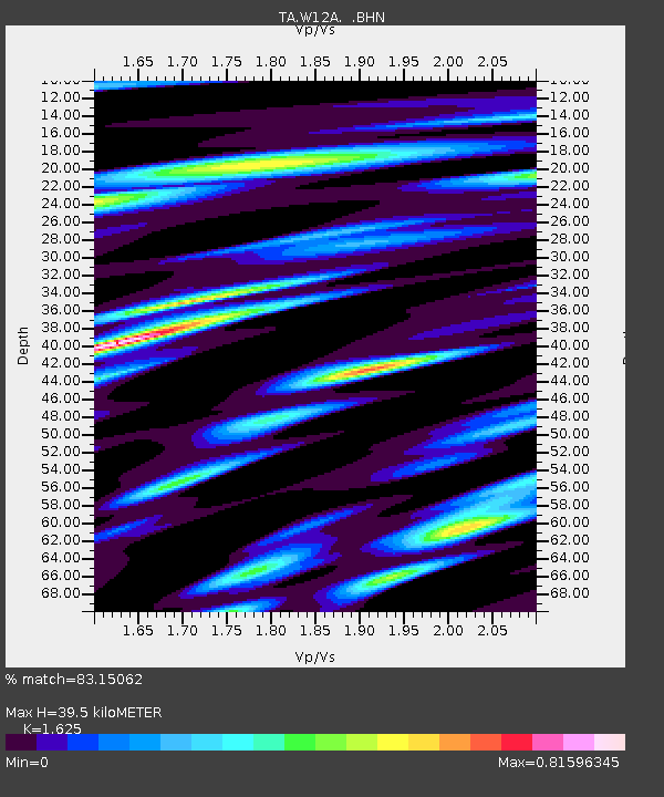
| Estimated Moho Depth: |
39.5 km |
| Estimated Crust Vp/Vs: |
1.62 |
| Assumed Crust Vp: |
6.276 km/s |
| Estimated Crust Vs: |
3.862 km/s |
| Estimated Crust Poisson's Ratio: |
0.20 |
|
| Radial Match: |
83.15062 % |
| Radial Bump: |
400 |
| Transverse Match: |
76.276886 % |
| Transverse Bump: |
400 |
| SOD ConfigId: |
132717 |
| Insert Time: |
2010-03-06 22:13:50.894 +0000 |
| GWidth: |
2.5 |
| Max Bumps: |
400 |
| Tol: |
0.001 |
|
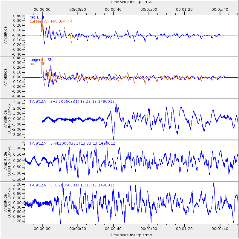
Signal To Noise
| Channel | StoN | STA | LTA |
| TA:W12A: :BHN:20060331T13:33:13.149001Z | 0.8899724 | 1.8562432E-7 | 2.0857313E-7 |
| TA:W12A: :BHE:20060331T13:33:13.149001Z | 0.5044227 | 9.4915855E-8 | 1.8816729E-7 |
| TA:W12A: :BHZ:20060331T13:33:13.149001Z | 0.91401327 | 2.1358211E-7 | 2.3367508E-7 |
| Arrivals |
| Ps | 4.0 SECOND |
| PpPs | 16 SECOND |
| PsPs/PpSs | 20 SECOND |


