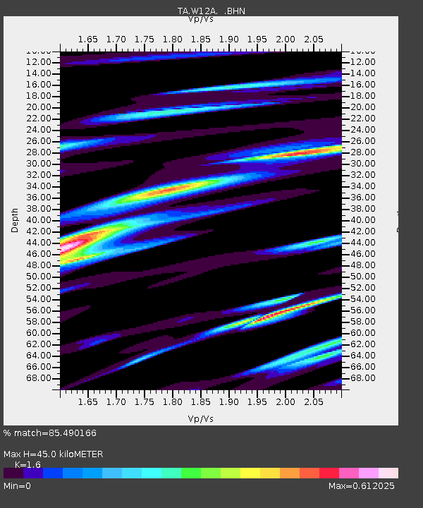
W12A Cal Nev Ari, NV, USA - Earthquake Result Viewer
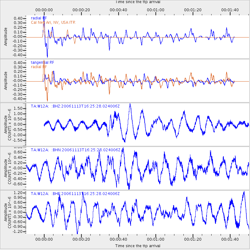
Earthquake location: New Britain Region, P.N.G.
Earthquake latitude/longitude: -6.4/151.2
Earthquake time(UTC): 2006/11/13 (317) 16:12:28 GMT
Earthquake Depth: 11 km
Earthquake Magnitude: 6.1 MB, 5.9 MS, 6.2 MW, 6.1 MW
Earthquake Catalog/Contributor: WHDF/NEIC
Network: TA USArray Transportable Network (new EarthScope stations)
Station: W12A Cal Nev Ari, NV, USA
Lat/Lon: 35.30 N/114.87 W
Elevation: 774 m
Distance: 96.8 deg
Az: 55.273 deg
Baz: 267.032 deg
Ray Param: 0.04039918
Estimated Moho Depth: 45.0 km
Estimated Crust Vp/Vs: 1.60
Assumed Crust Vp: 6.276 km/s
Estimated Crust Vs: 3.922 km/s
Estimated Crust Poisson's Ratio: 0.18
Radial Match: 85.490166 %
Radial Bump: 400
Transverse Match: 61.984142 %
Transverse Bump: 400
SOD ConfigId: 2564
Insert Time: 2010-03-06 22:13:51.887 +0000
GWidth: 2.5
Max Bumps: 400
Tol: 0.001

Signal To Noise

ChannelStoNSTALTA
TA:W12A: :BHN:20061113T16:25:28.024006Z1.87275422.8870824E-71.5416238E-7
TA:W12A: :BHE:20061113T16:25:28.024006Z2.11065444.8339604E-72.2902661E-7
TA:W12A: :BHZ:20061113T16:25:28.024006Z1.44920914.0065873E-72.7646718E-7
Arrivals
Ps4.4 SECOND
PpPs18 SECOND
PsPs/PpSs23 SECOND