You are here: Home > Network List > TA - USArray Transportable Network (new EarthScope stations) Stations List
> Station W12A Cal Nev Ari, NV, USA > Earthquake Result Viewer
W12A Cal Nev Ari, NV, USA - Earthquake Result Viewer
| Earthquake location: |
Tonga Islands Region |
| Earthquake latitude/longitude: |
-23.6/-175.3 |
| Earthquake time(UTC): |
2006/10/08 (281) 13:50:24 GMT |
| Earthquake Depth: |
10 km |
| Earthquake Magnitude: |
5.6 MB, 5.6 MS, 5.8 MW, 5.7 MW |
| Earthquake Catalog/Contributor: |
WHDF/NEIC |
|
| Network: |
TA USArray Transportable Network (new EarthScope stations) |
| Station: |
W12A Cal Nev Ari, NV, USA |
| Lat/Lon: |
35.30 N/114.87 W |
| Elevation: |
774 m |
|
| Distance: |
81.8 deg |
| Az: |
45.931 deg |
| Baz: |
233.716 deg |
| Ray Param: |
0.047312647 |
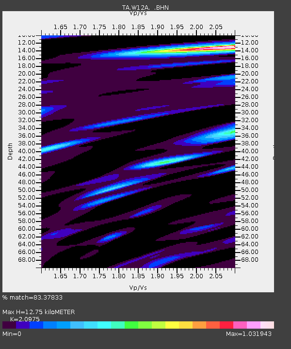
| Estimated Moho Depth: |
12.75 km |
| Estimated Crust Vp/Vs: |
2.10 |
| Assumed Crust Vp: |
6.276 km/s |
| Estimated Crust Vs: |
2.992 km/s |
| Estimated Crust Poisson's Ratio: |
0.35 |
|
| Radial Match: |
83.37833 % |
| Radial Bump: |
400 |
| Transverse Match: |
69.45364 % |
| Transverse Bump: |
400 |
| SOD ConfigId: |
2665 |
| Insert Time: |
2010-03-06 22:14:06.691 +0000 |
| GWidth: |
2.5 |
| Max Bumps: |
400 |
| Tol: |
0.001 |
|
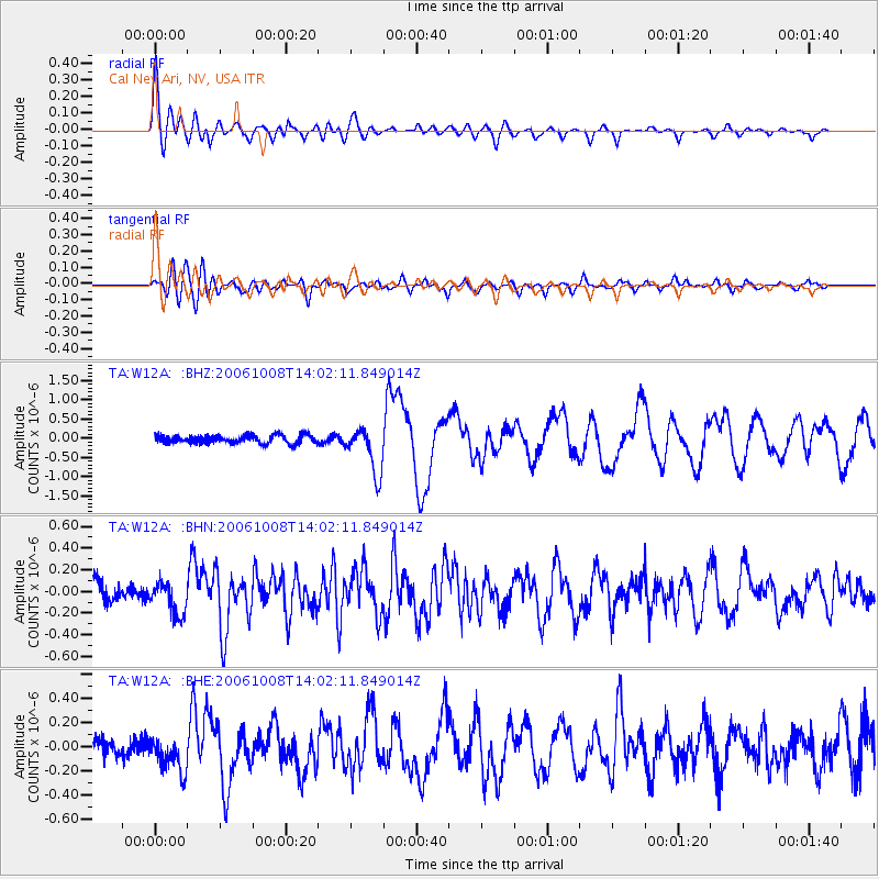
Signal To Noise
| Channel | StoN | STA | LTA |
| TA:W12A: :BHN:20061008T14:02:11.849014Z | 1.4306697 | 1.492919E-7 | 1.0435107E-7 |
| TA:W12A: :BHE:20061008T14:02:11.849014Z | 1.3889495 | 1.4866318E-7 | 1.07032804E-7 |
| TA:W12A: :BHZ:20061008T14:02:11.849014Z | 5.69531 | 6.018162E-7 | 1.0566873E-7 |
| Arrivals |
| Ps | 2.3 SECOND |
| PpPs | 6.2 SECOND |
| PsPs/PpSs | 8.4 SECOND |


