You are here: Home > Network List > TA - USArray Transportable Network (new EarthScope stations) Stations List
> Station W12A Cal Nev Ari, NV, USA > Earthquake Result Viewer
W12A Cal Nev Ari, NV, USA - Earthquake Result Viewer
| Earthquake location: |
Off Coast Of Central Chile |
| Earthquake latitude/longitude: |
-28.7/-72.5 |
| Earthquake time(UTC): |
2006/07/16 (197) 11:42:41 GMT |
| Earthquake Depth: |
10 km |
| Earthquake Magnitude: |
5.9 MB, 5.7 MS, 6.2 MW, 6.2 MW |
| Earthquake Catalog/Contributor: |
WHDF/NEIC |
|
| Network: |
TA USArray Transportable Network (new EarthScope stations) |
| Station: |
W12A Cal Nev Ari, NV, USA |
| Lat/Lon: |
35.30 N/114.87 W |
| Elevation: |
774 m |
|
| Distance: |
75.2 deg |
| Az: |
325.264 deg |
| Baz: |
142.274 deg |
| Ray Param: |
0.051856548 |
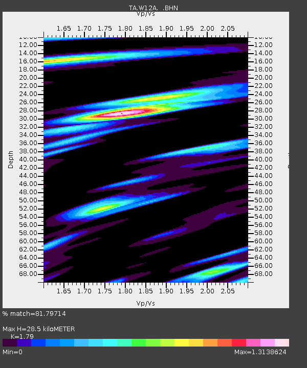
| Estimated Moho Depth: |
28.5 km |
| Estimated Crust Vp/Vs: |
1.79 |
| Assumed Crust Vp: |
6.276 km/s |
| Estimated Crust Vs: |
3.506 km/s |
| Estimated Crust Poisson's Ratio: |
0.27 |
|
| Radial Match: |
81.79714 % |
| Radial Bump: |
400 |
| Transverse Match: |
79.58513 % |
| Transverse Bump: |
400 |
| SOD ConfigId: |
2665 |
| Insert Time: |
2010-03-06 22:14:24.663 +0000 |
| GWidth: |
2.5 |
| Max Bumps: |
400 |
| Tol: |
0.001 |
|
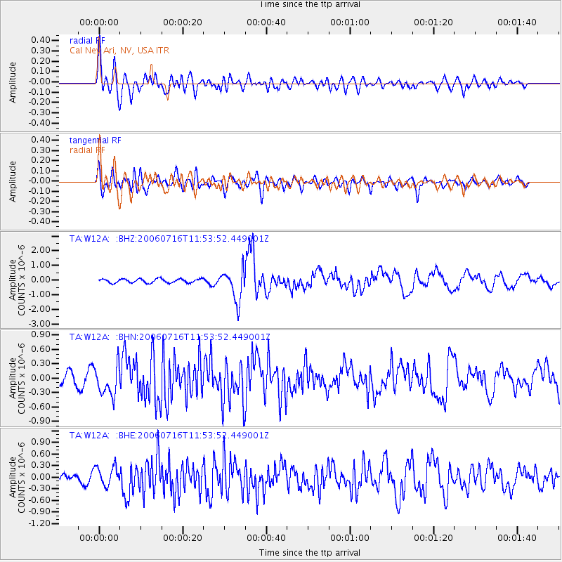
Signal To Noise
| Channel | StoN | STA | LTA |
| TA:W12A: :BHN:20060716T11:53:52.449001Z | 2.5609167 | 3.1657527E-7 | 1.2361794E-7 |
| TA:W12A: :BHE:20060716T11:53:52.449001Z | 3.153987 | 2.4725784E-7 | 7.839533E-8 |
| TA:W12A: :BHZ:20060716T11:53:52.449001Z | 8.1994705 | 1.0843675E-6 | 1.3224846E-7 |
| Arrivals |
| Ps | 3.7 SECOND |
| PpPs | 12 SECOND |
| PsPs/PpSs | 16 SECOND |


