You are here: Home > Network List > TA - USArray Transportable Network (new EarthScope stations) Stations List
> Station W12A Cal Nev Ari, NV, USA > Earthquake Result Viewer
W12A Cal Nev Ari, NV, USA - Earthquake Result Viewer
| Earthquake location: |
Tonga Islands |
| Earthquake latitude/longitude: |
-20.6/-174.0 |
| Earthquake time(UTC): |
2006/05/04 (124) 11:25:26 GMT |
| Earthquake Depth: |
11 km |
| Earthquake Magnitude: |
5.7 MB, 5.8 MS, 6.0 MW, 5.8 MW |
| Earthquake Catalog/Contributor: |
WHDF/NEIC |
|
| Network: |
TA USArray Transportable Network (new EarthScope stations) |
| Station: |
W12A Cal Nev Ari, NV, USA |
| Lat/Lon: |
35.30 N/114.87 W |
| Elevation: |
774 m |
|
| Distance: |
78.9 deg |
| Az: |
45.694 deg |
| Baz: |
235.059 deg |
| Ray Param: |
0.049297743 |
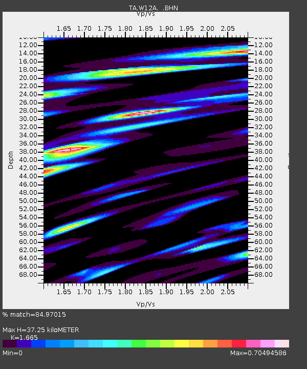
| Estimated Moho Depth: |
37.25 km |
| Estimated Crust Vp/Vs: |
1.66 |
| Assumed Crust Vp: |
6.276 km/s |
| Estimated Crust Vs: |
3.769 km/s |
| Estimated Crust Poisson's Ratio: |
0.22 |
|
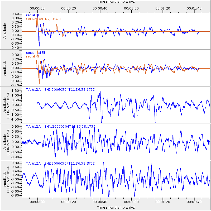
| Radial Match: |
84.97015 % |
| Radial Bump: |
400 |
| Transverse Match: |
70.97365 % |
| Transverse Bump: |
400 |
| SOD ConfigId: |
2669 |
| Insert Time: |
2010-03-06 22:14:40.504 +0000 |
| GWidth: |
2.5 |
| Max Bumps: |
400 |
| Tol: |
0.001 |
|
Signal To Noise
| Channel | StoN | STA | LTA |
| TA:W12A: :BHN:20060504T11:36:58.175Z | 1.5153438 | 1.4435649E-7 | 9.5263196E-8 |
| TA:W12A: :BHE:20060504T11:36:58.175Z | 1.5553591 | 3.2713285E-7 | 2.1032623E-7 |
| TA:W12A: :BHZ:20060504T11:36:58.175Z | 2.7052746 | 5.7274775E-7 | 2.1171519E-7 |
| Arrivals |
| Ps | 4.1 SECOND |
| PpPs | 15 SECOND |
| PsPs/PpSs | 19 SECOND |


