You are here: Home > Network List > GS - US Geological Survey Networks Stations List
> Station OK046 Pawnee, OK, Station 46 > Earthquake Result Viewer
OK046 Pawnee, OK, Station 46 - Earthquake Result Viewer

| Earthquake location: |
Central Italy |
| Earthquake latitude/longitude: |
42.9/13.1 |
| Earthquake time(UTC): |
2016/10/30 (304) 06:40:19 GMT |
| Earthquake Depth: |
10 km |
| Earthquake Magnitude: |
6.6 MWW, 6.6 MWR |
| Earthquake Catalog/Contributor: |
NEIC PDE/NEIC COMCAT |
|
| Network: |
GS US Geological Survey Networks |
| Station: |
OK046 Pawnee, OK, Station 46 |
| Lat/Lon: |
36.40 N/96.91 W |
| Elevation: |
294 m |
|
| Distance: |
78.6 deg |
| Az: |
309.338 deg |
| Baz: |
44.822 deg |
| Ray Param: |
0.049524706 |
| Estimated Moho Depth: |
40.75 km |
| Estimated Crust Vp/Vs: |
1.84 |
| Assumed Crust Vp: |
6.483 km/s |
| Estimated Crust Vs: |
3.533 km/s |
| Estimated Crust Poisson's Ratio: |
0.29 |
|
| Radial Match: |
92.66357 % |
| Radial Bump: |
354 |
| Transverse Match: |
77.99644 % |
| Transverse Bump: |
400 |
| SOD ConfigId: |
1815711 |
| Insert Time: |
2016-11-13 06:42:55.158 +0000 |
| GWidth: |
2.5 |
| Max Bumps: |
400 |
| Tol: |
0.001 |
|
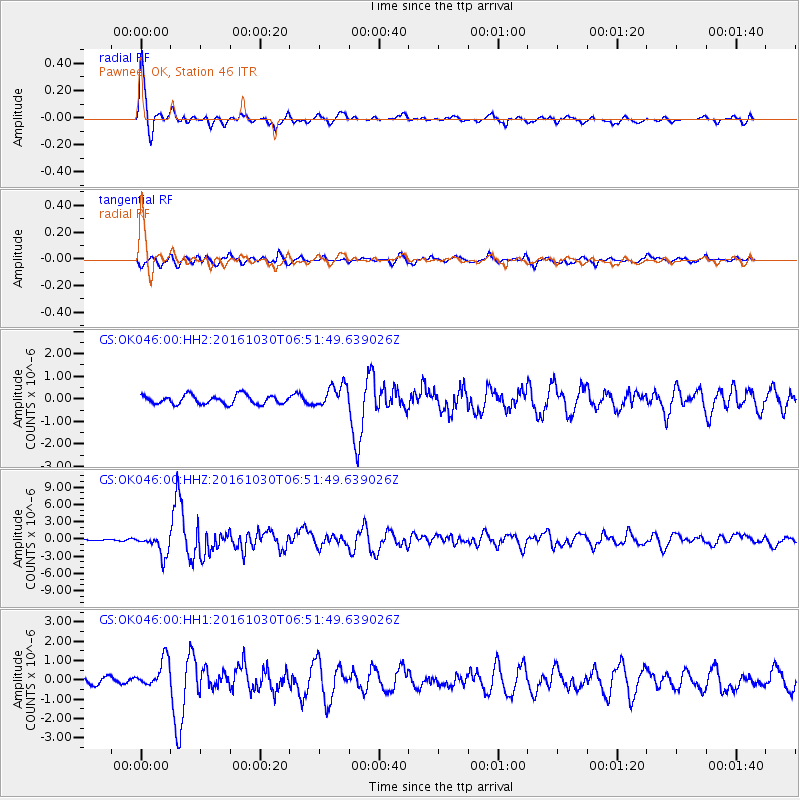
Signal To Noise
| Channel | StoN | STA | LTA |
| GS:OK046:00:HHZ:20161030T06:51:49.639026Z | 15.60781 | 1.8426082E-6 | 1.1805681E-7 |
| GS:OK046:00:HH1:20161030T06:51:49.639026Z | 4.354714 | 7.3199294E-7 | 1.6809209E-7 |
| GS:OK046:00:HH2:20161030T06:51:49.639026Z | 2.4818919 | 4.905129E-7 | 1.9763668E-7 |
| Arrivals |
| Ps | 5.4 SECOND |
| PpPs | 17 SECOND |
| PsPs/PpSs | 23 SECOND |


