
Station GS OK046 - Pawnee, OK, Station 46
Network: GS - US Geological Survey Networks
Nearby stations (2 deg radius)
| Station | Name | (Lat, Lon) | Start / End | Elevation |
| OK046 | Pawnee, OK, Station 46 | (36.40, -96.91) | 2016-09-06 / 2599-12-31 | 294 m |
| Crust2 Type: | D5,thick Platform 2 km seds. |
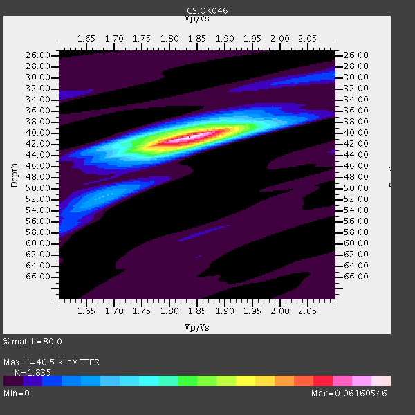
| Thickness Estimate: | 40 km |
| Thickness StdDev: | 0.2 km |
| Vp/Vs Estimate: | 1.84 |
| Vp/Vs StdDev: | 0.01 |
| Vs Estimate: | 3.533 km/s |
| Poisson's Ratio: | 0.29 |
| Peak Value: | 0.06 |
| Assumed Vp: | 6.483 km/s |
| Ps Weight: | 0.33333334 |
| PpPs Weight: | 0.33333334 |
| PsPs Weight: | 0.33333328 |
| Residual Complexity: | 0.407 |
| Nearby stations H: | +- |
| (2.0 deg) Vp/Vs: | +- |
6 with match > 90% ( 21.428572 %) and 9 with match > 80% ( 32.142857 %) out of 28.
Download stack as xyz text file.
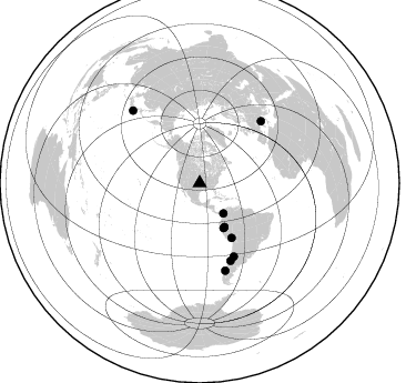
Azimuth Distribution of Events:
Prior Results for this Station
| Study | Thickness | Vp/Vs | Vp | Vs | Poissons Ratio | Extra |
| EARS | 40 km | 1.84 | 6.483 km/s | 3.533 km/s | 0.29 | |
| Crust2.0 | 46 km | 1.78 | 6.483 km/s | 3.648 km/s | 0.27 | D5,thick Platform 2 km seds. |
| Global Maxima | 40 km | 1.84 | 6.483 km/s | 3.533 km/s | 0.29 | amp=0.06160546 |
| Local Maxima 1 | 42 km | 1.83 | 6.483 km/s | 3.547 km/s | 0.29 | amp=0.027415952 |
| Local Maxima 2 | 40 km | 1.77 | 6.483 km/s | 3.668 km/s | 0.26 | amp=0.019739788 |
| Local Maxima 3 | 51 km | 1.68 | 6.483 km/s | 3.859 km/s | 0.23 | amp=0.008717273 |
| Local Maxima 4 | 29 km | 2.10 | 6.483 km/s | 3.091 km/s | 0.35 | amp=0.007138038 |
| Predicted Arrivals for vertical incidence (zero ray parameter) | |
| Ps | 5.22 SECOND |
| PpPs | 17.71 SECOND |
| PsPs/PpSs | 22.93 SECOND |
Events Processed for this Station
Download zip of receiver functions as SAC
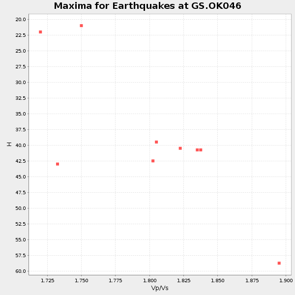
Plot maxima for each earthquake.
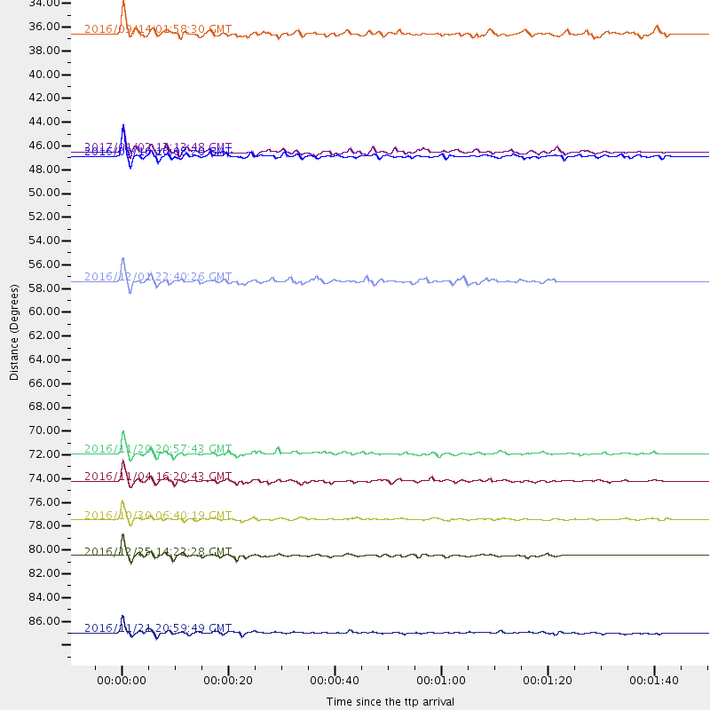
Events Used in the Stack
(9 events)| Radial Match | Distance | Baz | FERegion | Time | Lat/Lon | Depth | Magnitude |
| 97.1268 | 72.6 deg | 155.072 deg | San Juan Province, Argentina | 2016/11/20 20:57:43 GMT | (-31.6, -68.8) | 116 km | 6.4 MWP, 6.5 MWB |
| 97.000916 | 45.7 deg | 151.71 deg | Northern Peru | 2016/09/10 10:08:20 GMT | (-5.6, -77.0) | 114 km | 6.0 MB |
| 95.68575 | 81.9 deg | 163.674 deg | Southern Chile | 2016/12/25 14:22:28 GMT | (-43.3, -74.5) | 15 km | 7.7 Mi |
| 95.30859 | 88.9 deg | 317.325 deg | Near East Coast Of Honshu, Japan | 2016/11/21 20:59:49 GMT | (37.4, 141.4) | 11 km | 6.9 MWB, 7.3 MI |
| 94.64217 | 75.1 deg | 158.24 deg | Chile-Argentina Border Region | 2016/11/04 16:20:43 GMT | (-35.1, -71.0) | 91 km | 6.4 MWP, 6.4 MWW |
| 92.66357 | 78.6 deg | 44.822 deg | Central Italy | 2016/10/30 06:40:19 GMT | (42.9, 13.1) | 10 km | 6.6 MWW, 6.6 MWR |
| 85.68271 | 45.4 deg | 150.531 deg | Northern Peru | 2017/01/02 13:13:48 GMT | (-4.9, -76.3) | 108 km | 5.9 Mwb |
| 83.31708 | 34.6 deg | 141.664 deg | Northern Colombia | 2016/09/14 01:58:30 GMT | (7.3, -76.1) | 10 km | 5.9 MWP |
| 80.15826 | 57.0 deg | 149.624 deg | Southern Peru | 2016/12/01 22:40:26 GMT | (-15.3, -70.8) | 10 km | 6.3 Mww |
Losers
(19 events)| Radial Match | Distance | Baz | FERegion | Time | Lat/Lon | Depth | Magnitude | Reason |
| 80.0593 | 78.5 deg | 44.781 deg | Central Italy | 2016/10/26 19:18:08 GMT | (42.9, 13.0) | 10 km | 6.1 MWW, 6.0 MWB, 6.1 MWR | |
| 76.07992 | 48.1 deg | 312.893 deg | Unimak Island Region, Alaska | 2016/10/27 11:53:18 GMT | (53.6, -163.3) | 17 km | 5.8 MWP, 5.8 MI | |
| 74.006546 | 89.6 deg | 250.609 deg | Tonga Islands | 2016/10/25 16:10:01 GMT | (-15.4, -174.8) | 0.0 km | 5.8 | |
| 70.09719 | 72.2 deg | 183.492 deg | Southeast Of Easter Island | 2016/10/08 04:37:41 GMT | (-36.0, -101.0) | 10 km | 5.6 MWC, 5.6 MWC | |
| 68.988815 | 78.6 deg | 44.852 deg | Central Italy | 2016/10/26 17:10:37 GMT | (42.9, 13.0) | 10 km | 5.5 MWW | |
| 68.963844 | 80.6 deg | 318.43 deg | East Of Kuril Islands | 2016/10/23 20:25:26 GMT | (44.0, 148.2) | 30 km | 5.8 MB | |
| 67.78263 | 73.5 deg | 152.52 deg | Cordoba Province, Argentina | 2016/09/09 00:03:43 GMT | (-31.4, -65.7) | 151 km | 5.6 MWR | |
| 66.22393 | 52.2 deg | 146.943 deg | Peru-Brazil Border Region | 2016/12/18 13:30:11 GMT | (-10.0, -71.0) | 619 km | 6.4 Mww | |
| 65.383224 | 83.7 deg | 35.976 deg | Romania | 2016/09/23 23:11:20 GMT | (45.7, 26.6) | 88 km | 5.6 MO | |
| 61.255264 | 94.9 deg | 249.084 deg | Fiji Islands Region | 2016/09/24 21:28:42 GMT | (-19.8, -178.3) | 594 km | 6.8 MO | |
| 54.888874 | 69.9 deg | 152.335 deg | La Rioja Province, Argentina | 2016/11/13 01:01:51 GMT | (-28.1, -67.3) | 121 km | 5.7 MB | |
| 52.80979 | 50.0 deg | 156.522 deg | Near Coast Of Peru | 2016/12/17 07:23:30 GMT | (-10.9, -78.8) | 38 km | 5.0 mb | |
| 50.743732 | 46.3 deg | 93.371 deg | Northern Mid-Atlantic Ridge | 2016/09/09 17:17:54 GMT | (22.1, -45.9) | 10 km | 5.5 MB | |
| 49.652393 | 84.9 deg | 43.28 deg | Greece-Albania Border Region | 2016/10/15 20:14:49 GMT | (39.8, 20.7) | 22 km | 5.5 MWW, 5.3 MWB, 5.5 MWC | |
| 43.677547 | 63.7 deg | 319.63 deg | Komandorskiye Ostrova Region | 2016/09/07 20:07:36 GMT | (54.6, 168.6) | 10 km | 5.5 MB | |
| 40.93137 | 93.4 deg | 312.202 deg | Southeast Of Honshu, Japan | 2016/09/20 16:21:16 GMT | (30.5, 142.1) | 10 km | 6.1 MWW, 6.0 MWB | |
| 38.584496 | 88.9 deg | 317.324 deg | Near East Coast Of Honshu, Japan | 2016/12/30 20:08:27 GMT | (37.4, 141.4) | 12 km | 5.5 mb | |
| 38.00574 | 37.9 deg | 114.464 deg | Leeward Islands | 2016/10/18 22:08:14 GMT | (15.2, -61.5) | 143 km | 5.6 MWW, 5.6 MWB | |
| 30.782274 | 81.1 deg | 47.367 deg | Tyrrhenian Sea | 2016/10/28 20:02:48 GMT | (39.3, 13.5) | 448 km | 5.8 MWW, 5.8 MWB |

