You are here: Home > Network List > 1E - GSC-BCOGC Induced Seismicity Study Stations List
> Station MONT6 Z > Earthquake Result Viewer
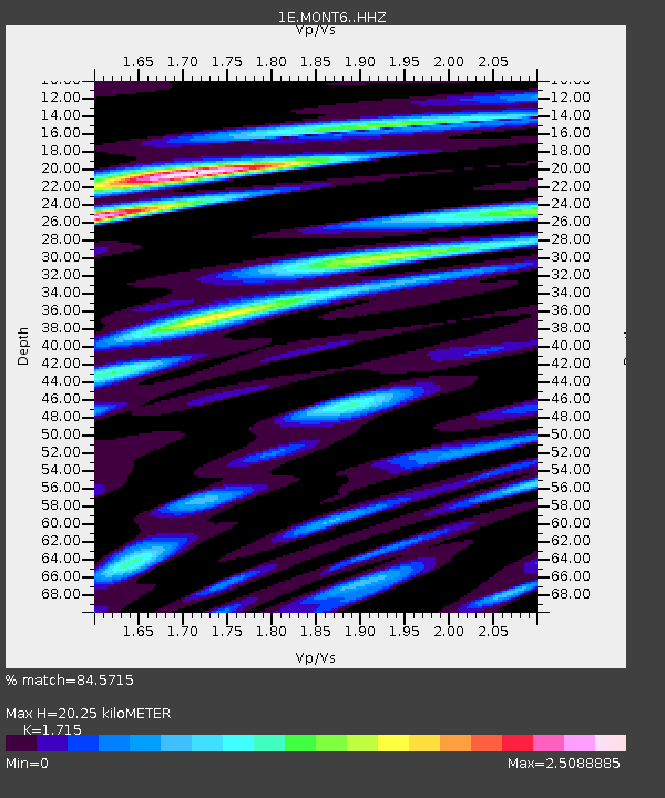
MONT6 Z - Earthquake Result Viewer
| Earthquake location: |
Northern Peru |
| Earthquake latitude/longitude: |
-5.9/-75.3 |
| Earthquake time(UTC): |
2019/05/26 (146) 07:41:13 GMT |
| Earthquake Depth: |
105 km |
| Earthquake Magnitude: |
7.5 Mi |
| Earthquake Catalog/Contributor: |
NEIC PDE/at |
|
| Network: |
1E GSC-BCOGC Induced Seismicity Study |
| Station: |
MONT6 Z |
| Lat/Lon: |
56.11 N/121.02 W |
| Elevation: |
650 m |
|
| Distance: |
72.3 deg |
| Az: |
335.101 deg |
| Baz: |
131.612 deg |
| Ray Param: |
0.053514197 |
| Estimated Moho Depth: |
20.25 km |
| Estimated Crust Vp/Vs: |
1.72 |
| Assumed Crust Vp: |
6.291 km/s |
| Estimated Crust Vs: |
3.668 km/s |
| Estimated Crust Poisson's Ratio: |
0.24 |
|
| Radial Match: |
84.5715 % |
| Radial Bump: |
400 |
| Transverse Match: |
65.49857 % |
| Transverse Bump: |
400 |
| SOD ConfigId: |
18369291 |
| Insert Time: |
2019-06-09 07:41:25.921 +0000 |
| GWidth: |
2.5 |
| Max Bumps: |
400 |
| Tol: |
0.001 |
|

Signal To Noise
| Channel | StoN | STA | LTA |
| 1E:MONT6: :HHZ:20190526T07:51:56.090027Z | 17.285118 | 1.1486071E-5 | 6.645064E-7 |
| 1E:MONT6: :HHN:20190526T07:51:56.090027Z | 12.159047 | 5.2558676E-6 | 4.322598E-7 |
| 1E:MONT6: :HHE:20190526T07:51:56.090027Z | 8.031819 | 3.9831793E-6 | 4.959249E-7 |
| Arrivals |
| Ps | 2.4 SECOND |
| PpPs | 8.4 SECOND |
| PsPs/PpSs | 11 SECOND |


