You are here: Home > Network List > TA - USArray Transportable Network (new EarthScope stations) Stations List
> Station S04C Ingram Canyon, Westley, CA, USA > Earthquake Result Viewer
S04C Ingram Canyon, Westley, CA, USA - Earthquake Result Viewer
| Earthquake location: |
Vanuatu Islands |
| Earthquake latitude/longitude: |
-14.3/167.3 |
| Earthquake time(UTC): |
2005/02/08 (039) 14:48:21 GMT |
| Earthquake Depth: |
206 km |
| Earthquake Magnitude: |
6.1 MB, 6.8 MW, 6.7 MW |
| Earthquake Catalog/Contributor: |
WHDF/NEIC |
|
| Network: |
TA USArray Transportable Network (new EarthScope stations) |
| Station: |
S04C Ingram Canyon, Westley, CA, USA |
| Lat/Lon: |
37.51 N/121.33 W |
| Elevation: |
310 m |
|
| Distance: |
84.4 deg |
| Az: |
49.235 deg |
| Baz: |
247.434 deg |
| Ray Param: |
0.045005813 |
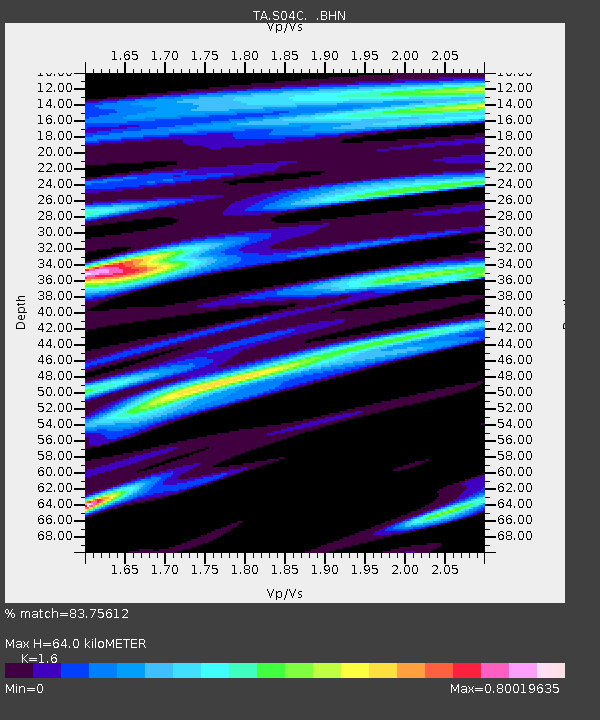
| Estimated Moho Depth: |
64.0 km |
| Estimated Crust Vp/Vs: |
1.60 |
| Assumed Crust Vp: |
6.391 km/s |
| Estimated Crust Vs: |
3.994 km/s |
| Estimated Crust Poisson's Ratio: |
0.18 |
|
| Radial Match: |
83.75612 % |
| Radial Bump: |
400 |
| Transverse Match: |
81.54701 % |
| Transverse Bump: |
400 |
| SOD ConfigId: |
5233 |
| Insert Time: |
2010-03-06 22:56:33.769 +0000 |
| GWidth: |
2.5 |
| Max Bumps: |
400 |
| Tol: |
0.001 |
|
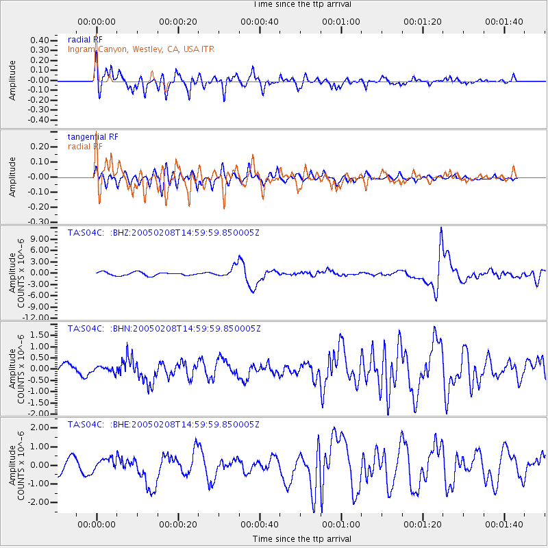
Signal To Noise
| Channel | StoN | STA | LTA |
| TA:S04C: :BHN:20050208T14:59:59.850005Z | 0.49199548 | 1.239631E-7 | 2.5195982E-7 |
| TA:S04C: :BHE:20050208T14:59:59.850005Z | 0.8125291 | 3.4246528E-7 | 4.2148068E-7 |
| TA:S04C: :BHZ:20050208T14:59:59.850005Z | 3.4682045 | 1.5513879E-6 | 4.473173E-7 |
| Arrivals |
| Ps | 6.2 SECOND |
| PpPs | 25 SECOND |
| PsPs/PpSs | 32 SECOND |


