
Station TA S04C - Ingram Canyon, Westley, CA, USA
Network: TA - USArray Transportable Network (new EarthScope stations)
Nearby stations (2 deg radius)
| Station | Name | (Lat, Lon) | Start / End | Elevation |
| S04C | Ingram Canyon, Westley, CA, USA | (37.51, -121.33) | 2004-12-20 / 2499-01-01 | 310 m |
| Crust2 Type: | T4,Margin /shield transition, East Siberia, 2 km seds. |
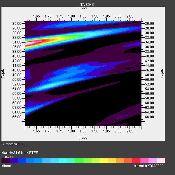
| Thickness Estimate: | 34 km |
| Thickness StdDev: | 0.3 km |
| Vp/Vs Estimate: | 1.60 |
| Vp/Vs StdDev: | 0.01 |
| Vs Estimate: | 3.994 km/s |
| Poisson's Ratio: | 0.18 |
| Peak Value: | 0.03 |
| Assumed Vp: | 6.391 km/s |
| Ps Weight: | 0.33333334 |
| PpPs Weight: | 0.33333334 |
| PsPs Weight: | 0.33333328 |
| Residual Complexity: | 0.616 |
| Nearby stations H: | 34 km +- 0.7 km |
| (2.0 deg) Vp/Vs: | 1.62 +- 0.02 |
14 with match > 90% ( 41.17647 %) and 34 with match > 80% ( 100.0 %) out of 34.
Download stack as xyz text file.
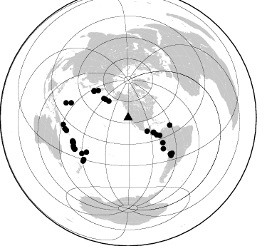
Azimuth Distribution of Events:
Prior Results for this Station
| Study | Thickness | Vp/Vs | Vp | Vs | Poissons Ratio | Extra |
| EARS | 34 km | 1.60 | 6.391 km/s | 3.994 km/s | 0.18 | |
| Crust2.0 | 32 km | 1.79 | 6.391 km/s | 3.572 km/s | 0.27 | T4,Margin /shield transition, East Siberia, 2 km seds. |
| Global Maxima | 34 km | 1.60 | 6.391 km/s | 3.994 km/s | 0.18 | amp=0.027033722 |
| Local Maxima 1 | 35 km | 1.65 | 6.391 km/s | 3.873 km/s | 0.21 | amp=0.01194304 |
| Local Maxima 2 | 52 km | 1.70 | 6.391 km/s | 3.759 km/s | 0.24 | amp=0.010590583 |
| Local Maxima 3 | 31 km | 1.77 | 6.391 km/s | 3.616 km/s | 0.26 | amp=0.008404385 |
| Local Maxima 4 | 64 km | 1.61 | 6.391 km/s | 3.976 km/s | 0.18 | amp=0.0065785665 |
| Predicted Arrivals for vertical incidence (zero ray parameter) | |
| Ps | 3.24 SECOND |
| PpPs | 14.04 SECOND |
| PsPs/PpSs | 17.28 SECOND |
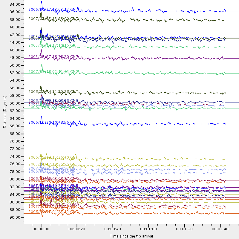
Events Processed for this Station
Download zip of receiver functions as SAC
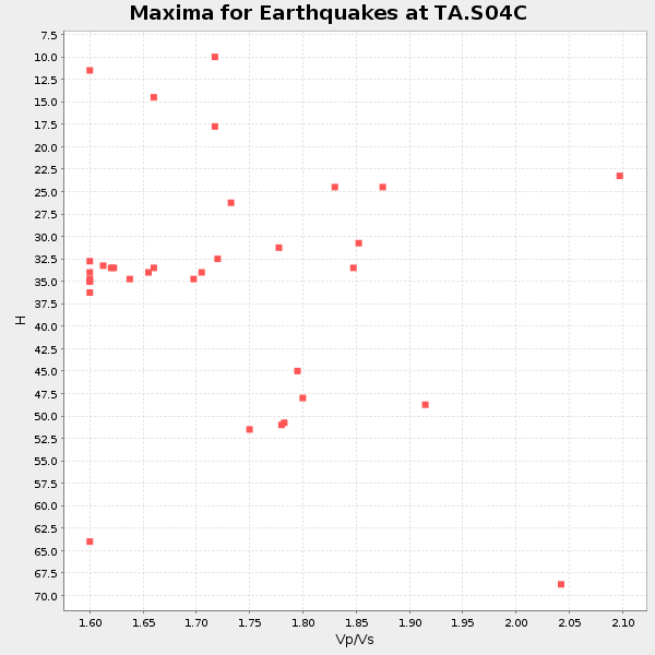
Plot maxima for each earthquake.
Events Used in the Stack
(34 events)| Radial Match | Distance | Baz | FERegion | Time | Lat/Lon | Depth | Magnitude |
| 97.941635 | 60.0 deg | 125.714 deg | Northern Peru | 2005/09/26 01:55:37 GMT | (-5.7, -76.4) | 115 km | 6.7 MB, 7.5 MW, 7.5 MW |
| 97.58268 | 60.5 deg | 307.494 deg | East Of Kuril Islands | 2007/01/13 04:23:21 GMT | (46.2, 154.5) | 10 km | 7.3 MB, 8.2 MS, 8.1 MW, 7.9 MW |
| 97.01418 | 75.9 deg | 230.48 deg | Tonga Islands | 2006/05/03 15:26:40 GMT | (-20.2, -174.1) | 55 km | 7.2 MB, 7.8 MS, 7.9 MW, 7.9 MW |
| 96.250114 | 85.0 deg | 246.152 deg | Vanuatu Islands | 2007/08/01 17:08:51 GMT | (-15.6, 167.7) | 120 km | 6.2 MB, 7.2 MW, 7.2 MW |
| 95.76488 | 87.6 deg | 226.282 deg | Kermadec Islands Region | 2006/05/16 10:39:23 GMT | (-31.8, -179.3) | 152 km | 6.8 MB, 7.4 MW, 7.4 MW |
| 95.48802 | 88.5 deg | 258.251 deg | Solomon Islands | 2007/04/01 20:39:56 GMT | (-8.5, 157.0) | 10 km | 6.8 MB, 7.9 MS, 8.1 MW, 7.7 ME |
| 94.26468 | 77.9 deg | 130.474 deg | Chile-Bolivia Border Region | 2005/11/17 19:26:56 GMT | (-22.3, -67.9) | 163 km | 6.0 MB, 6.9 MW, 6.8 MW |
| 94.127075 | 87.2 deg | 241.241 deg | Vanuatu Islands | 2007/03/25 01:08:19 GMT | (-20.8, 169.4) | 35 km | 5.9 MB, 7.1 MS, 6.9 MW |
| 93.40702 | 40.9 deg | 120.458 deg | Near Coast Of Nicaragua | 2005/07/02 02:16:43 GMT | (11.2, -86.2) | 27 km | 5.6 MB, 6.4 MS, 6.6 MW, 6.6 MW |
| 93.08606 | 65.8 deg | 131.433 deg | Near Coast Of Peru | 2006/10/20 10:48:56 GMT | (-13.5, -76.7) | 23 km | 5.9 MB, 6.6 MS, 6.7 MW, 6.6 MW |
| 91.577896 | 56.8 deg | 311.927 deg | Near East Coast Of Kamchatka | 2006/08/24 21:50:36 GMT | (51.1, 157.5) | 43 km | 5.9 MB, 6.2 MS, 6.5 MW, 6.5 MW |
| 91.33004 | 84.2 deg | 245.728 deg | Vanuatu Islands | 2007/07/15 09:27:34 GMT | (-15.4, 168.6) | 8.0 km | 6.0 MB, 5.8 MS, 6.1 MW, 6.0 MW |
| 90.881516 | 90.1 deg | 260.104 deg | Solomon Islands | 2007/06/28 02:52:09 GMT | (-8.0, 154.6) | 10 km | 6.3 MB, 6.7 MS, 6.7 MW, 6.7 MW |
| 90.06404 | 85.0 deg | 245.94 deg | Vanuatu Islands | 2006/08/07 22:18:54 GMT | (-15.8, 167.8) | 141 km | 6.0 MB, 6.8 MW, 6.8 MW |
| 89.653366 | 82.6 deg | 284.394 deg | Mariana Islands | 2005/02/05 03:34:25 GMT | (16.0, 145.9) | 143 km | 6.3 MB, 6.6 MW, 6.5 MW |
| 89.62715 | 35.6 deg | 310.101 deg | Fox Islands, Aleutian Islands | 2007/07/15 13:08:00 GMT | (52.5, -168.0) | 10 km | 5.8 MB, 5.9 MS, 6.1 MW, 6.0 MW |
| 88.51813 | 41.4 deg | 119.785 deg | Nicaragua | 2005/08/03 11:03:15 GMT | (11.2, -85.5) | 14 km | 6.0 MB, 6.5 MS, 6.3 MW, 6.3 MW |
| 88.42351 | 79.1 deg | 128.863 deg | Jujuy Province, Argentina | 2007/07/21 15:34:52 GMT | (-22.2, -65.8) | 290 km | 5.8 MB, 6.4 MW, 6.3 MW |
| 88.02805 | 43.4 deg | 308.092 deg | Rat Islands, Aleutian Islands | 2005/06/14 17:10:16 GMT | (51.2, 179.4) | 51 km | 6.0 MB, 6.8 MW, 6.6 MW |
| 87.35596 | 86.2 deg | 242.862 deg | Vanuatu Islands | 2006/10/03 18:03:14 GMT | (-18.9, 169.0) | 171 km | 5.9 MB, 6.3 MW, 6.3 MW |
| 86.86833 | 40.6 deg | 308.75 deg | Andreanof Islands, Aleutian Is. | 2007/07/13 21:54:43 GMT | (51.8, -176.3) | 35 km | 5.7 MB, 5.6 MS, 6.0 MW, 5.9 MW |
| 86.20648 | 32.9 deg | 125.742 deg | Off Coast Of Chiapas, Mexico | 2006/06/27 13:03:12 GMT | (15.0, -94.2) | 29 km | 5.4 MB, 5.5 MS, 5.8 MW, 5.8 MW |
| 85.51477 | 86.5 deg | 239.725 deg | Southeast Of Loyalty Islands | 2007/07/27 14:46:26 GMT | (-21.5, 170.9) | 10 km | 6.0 MB, 6.0 MS, 6.1 MW, 6.1 MW |
| 85.47156 | 89.6 deg | 283.355 deg | W. Caroline Islands, Micronesia | 2005/01/16 20:17:52 GMT | (10.9, 140.8) | 25 km | 6.3 MB, 6.7 MS, 6.6 MW, 6.6 MW |
| 84.87189 | 46.7 deg | 121.008 deg | South Of Panama | 2005/08/27 18:38:20 GMT | (6.8, -82.4) | 10 km | 5.6 MB, 5.6 MS, 6.2 MW, 6.1 MW |
| 84.2403 | 91.7 deg | 263.955 deg | New Britain Region, P.N.G. | 2006/10/17 01:25:12 GMT | (-5.9, 151.0) | 32 km | 6.4 MB, 6.9 MS, 6.7 MW, 6.6 MW |
| 84.05459 | 87.1 deg | 239.551 deg | Southeast Of Loyalty Islands | 2005/04/11 17:08:53 GMT | (-22.0, 170.6) | 68 km | 6.0 MB, 6.8 MW, 6.8 MW |
| 83.75612 | 84.4 deg | 247.434 deg | Vanuatu Islands | 2005/02/08 14:48:21 GMT | (-14.3, 167.3) | 206 km | 6.1 MB, 6.8 MW, 6.7 MW |
| 83.62507 | 51.0 deg | 119.288 deg | South Of Panama | 2007/03/18 02:11:05 GMT | (4.6, -78.5) | 8.0 km | 6.4 MB, 5.7 MS, 6.2 MW, 6.1 MW |
| 83.025314 | 59.4 deg | 100.208 deg | Trinidad | 2006/09/29 13:08:26 GMT | (10.9, -61.8) | 53 km | 5.9 MB, 5.4 MS, 6.1 MW, 6.0 MW |
| 82.98994 | 82.1 deg | 232.282 deg | South Of Fiji Islands | 2006/02/26 03:08:27 GMT | (-23.6, -180.0) | 535 km | 5.9 MB, 6.4 MW, 6.4 MW |
| 82.97636 | 61.2 deg | 308.159 deg | Kuril Islands | 2006/10/01 09:06:02 GMT | (46.5, 153.2) | 19 km | 6.1 MB, 6.4 MS, 6.6 MW, 6.5 MW |
| 82.35697 | 80.0 deg | 131.251 deg | Chile-Argentina Border Region | 2006/08/25 00:44:46 GMT | (-24.4, -67.0) | 184 km | 5.9 MB, 6.6 MW, 6.6 MW |
| 81.53042 | 85.4 deg | 226.785 deg | Kermadec Islands, New Zealand | 2007/01/31 03:15:52 GMT | (-29.8, -178.0) | 34 km | 6.1 MB, 6.3 MS, 6.5 MW, 6.4 MW |
Losers
(0 events)| Radial Match | Distance | Baz | FERegion | Time | Lat/Lon | Depth | Magnitude | Reason |
