You are here: Home > Network List > TA - USArray Transportable Network (new EarthScope stations) Stations List
> Station S04C Ingram Canyon, Westley, CA, USA > Earthquake Result Viewer
S04C Ingram Canyon, Westley, CA, USA - Earthquake Result Viewer
| Earthquake location: |
Mariana Islands |
| Earthquake latitude/longitude: |
16.0/145.9 |
| Earthquake time(UTC): |
2005/02/05 (036) 03:34:25 GMT |
| Earthquake Depth: |
143 km |
| Earthquake Magnitude: |
6.3 MB, 6.6 MW, 6.5 MW |
| Earthquake Catalog/Contributor: |
WHDF/NEIC |
|
| Network: |
TA USArray Transportable Network (new EarthScope stations) |
| Station: |
S04C Ingram Canyon, Westley, CA, USA |
| Lat/Lon: |
37.51 N/121.33 W |
| Elevation: |
310 m |
|
| Distance: |
82.6 deg |
| Az: |
53.224 deg |
| Baz: |
284.394 deg |
| Ray Param: |
0.04644577 |
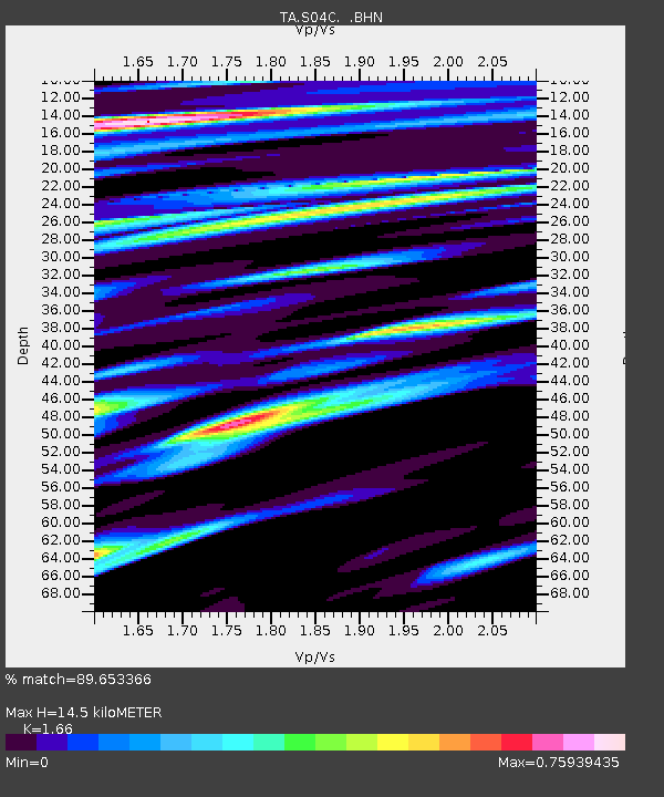
| Estimated Moho Depth: |
14.5 km |
| Estimated Crust Vp/Vs: |
1.66 |
| Assumed Crust Vp: |
6.391 km/s |
| Estimated Crust Vs: |
3.85 km/s |
| Estimated Crust Poisson's Ratio: |
0.22 |
|
| Radial Match: |
89.653366 % |
| Radial Bump: |
400 |
| Transverse Match: |
90.839 % |
| Transverse Bump: |
398 |
| SOD ConfigId: |
5233 |
| Insert Time: |
2010-03-06 22:56:35.673 +0000 |
| GWidth: |
2.5 |
| Max Bumps: |
400 |
| Tol: |
0.001 |
|

Signal To Noise
| Channel | StoN | STA | LTA |
| TA:S04C: :BHN:20050205T03:46:01.823994Z | 1.6807207 | 2.4539983E-7 | 1.4600869E-7 |
| TA:S04C: :BHE:20050205T03:46:01.823994Z | 1.2177178 | 2.2484478E-7 | 1.846444E-7 |
| TA:S04C: :BHZ:20050205T03:46:01.823994Z | 5.386709 | 7.076924E-7 | 1.3137749E-7 |
| Arrivals |
| Ps | 1.5 SECOND |
| PpPs | 5.9 SECOND |
| PsPs/PpSs | 7.4 SECOND |


