You are here: Home > Network List > TA - USArray Transportable Network (new EarthScope stations) Stations List
> Station S04C Ingram Canyon, Westley, CA, USA > Earthquake Result Viewer
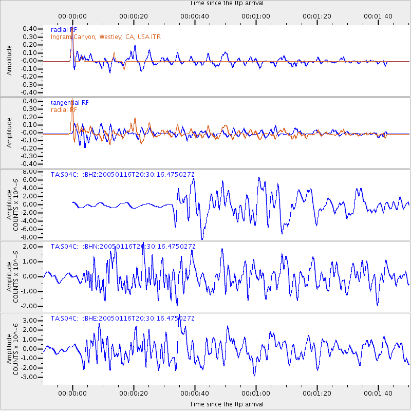
S04C Ingram Canyon, Westley, CA, USA - Earthquake Result Viewer

| Earthquake location: |
W. Caroline Islands, Micronesia |
| Earthquake latitude/longitude: |
10.9/140.8 |
| Earthquake time(UTC): |
2005/01/16 (016) 20:17:52 GMT |
| Earthquake Depth: |
25 km |
| Earthquake Magnitude: |
6.3 MB, 6.7 MS, 6.6 MW, 6.6 MW |
| Earthquake Catalog/Contributor: |
WHDF/NEIC |
|
| Network: |
TA USArray Transportable Network (new EarthScope stations) |
| Station: |
S04C Ingram Canyon, Westley, CA, USA |
| Lat/Lon: |
37.51 N/121.33 W |
| Elevation: |
310 m |
|
| Distance: |
89.6 deg |
| Az: |
51.988 deg |
| Baz: |
283.355 deg |
| Ray Param: |
0.041742675 |
| Estimated Moho Depth: |
48.0 km |
| Estimated Crust Vp/Vs: |
1.80 |
| Assumed Crust Vp: |
6.391 km/s |
| Estimated Crust Vs: |
3.55 km/s |
| Estimated Crust Poisson's Ratio: |
0.28 |
|
| Radial Match: |
85.47156 % |
| Radial Bump: |
400 |
| Transverse Match: |
88.668 % |
| Transverse Bump: |
400 |
| SOD ConfigId: |
5233 |
| Insert Time: |
2010-03-06 22:56:40.513 +0000 |
| GWidth: |
2.5 |
| Max Bumps: |
400 |
| Tol: |
0.001 |
|
Signal To Noise
| Channel | StoN | STA | LTA |
| TA:S04C: :BHN:20050116T20:30:16.475027Z | 0.7485698 | 2.0101416E-7 | 2.6853095E-7 |
| TA:S04C: :BHE:20050116T20:30:16.475027Z | 2.6534739 | 7.848439E-7 | 2.9577978E-7 |
| TA:S04C: :BHZ:20050116T20:30:16.475027Z | 4.4381247 | 1.922257E-6 | 4.3312372E-7 |
| Arrivals |
| Ps | 6.1 SECOND |
| PpPs | 21 SECOND |
| PsPs/PpSs | 27 SECOND |


