You are here: Home > Network List > TA - USArray Transportable Network (new EarthScope stations) Stations List
> Station S04C Ingram Canyon, Westley, CA, USA > Earthquake Result Viewer
S04C Ingram Canyon, Westley, CA, USA - Earthquake Result Viewer

| Earthquake location: |
Rat Islands, Aleutian Islands |
| Earthquake latitude/longitude: |
51.2/179.4 |
| Earthquake time(UTC): |
2005/06/14 (165) 17:10:16 GMT |
| Earthquake Depth: |
51 km |
| Earthquake Magnitude: |
6.0 MB, 6.8 MW, 6.6 MW |
| Earthquake Catalog/Contributor: |
WHDF/NEIC |
|
| Network: |
TA USArray Transportable Network (new EarthScope stations) |
| Station: |
S04C Ingram Canyon, Westley, CA, USA |
| Lat/Lon: |
37.51 N/121.33 W |
| Elevation: |
310 m |
|
| Distance: |
43.4 deg |
| Az: |
84.558 deg |
| Baz: |
308.092 deg |
| Ray Param: |
0.072456256 |
| Estimated Moho Depth: |
33.25 km |
| Estimated Crust Vp/Vs: |
1.61 |
| Assumed Crust Vp: |
6.391 km/s |
| Estimated Crust Vs: |
3.963 km/s |
| Estimated Crust Poisson's Ratio: |
0.19 |
|
| Radial Match: |
88.02805 % |
| Radial Bump: |
326 |
| Transverse Match: |
84.204926 % |
| Transverse Bump: |
400 |
| SOD ConfigId: |
144822 |
| Insert Time: |
2010-03-06 22:56:42.128 +0000 |
| GWidth: |
2.5 |
| Max Bumps: |
400 |
| Tol: |
0.001 |
|
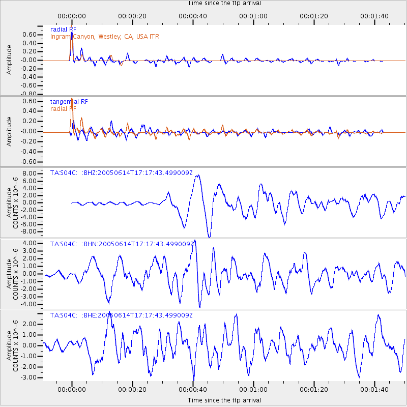
Signal To Noise
| Channel | StoN | STA | LTA |
| TA:S04C: :BHN:20050614T17:17:43.499009Z | 2.7425058 | 5.333386E-7 | 1.9447127E-7 |
| TA:S04C: :BHE:20050614T17:17:43.499009Z | 1.7349337 | 4.3123046E-7 | 2.485573E-7 |
| TA:S04C: :BHZ:20050614T17:17:43.499009Z | 4.5213428 | 1.3110711E-6 | 2.8997383E-7 |
| Arrivals |
| Ps | 3.4 SECOND |
| PpPs | 13 SECOND |
| PsPs/PpSs | 16 SECOND |


