You are here: Home > Network List > TA - USArray Transportable Network (new EarthScope stations) Stations List
> Station S04C Ingram Canyon, Westley, CA, USA > Earthquake Result Viewer
S04C Ingram Canyon, Westley, CA, USA - Earthquake Result Viewer
| Earthquake location: |
Southeast Of Loyalty Islands |
| Earthquake latitude/longitude: |
-22.0/170.6 |
| Earthquake time(UTC): |
2005/04/11 (101) 17:08:53 GMT |
| Earthquake Depth: |
68 km |
| Earthquake Magnitude: |
6.0 MB, 6.8 MW, 6.8 MW |
| Earthquake Catalog/Contributor: |
WHDF/NEIC |
|
| Network: |
TA USArray Transportable Network (new EarthScope stations) |
| Station: |
S04C Ingram Canyon, Westley, CA, USA |
| Lat/Lon: |
37.51 N/121.33 W |
| Elevation: |
310 m |
|
| Distance: |
87.1 deg |
| Az: |
47.613 deg |
| Baz: |
239.551 deg |
| Ray Param: |
0.043424763 |
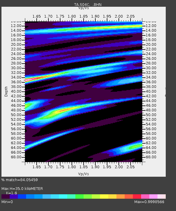
| Estimated Moho Depth: |
35.0 km |
| Estimated Crust Vp/Vs: |
1.60 |
| Assumed Crust Vp: |
6.391 km/s |
| Estimated Crust Vs: |
3.994 km/s |
| Estimated Crust Poisson's Ratio: |
0.18 |
|
| Radial Match: |
84.05459 % |
| Radial Bump: |
400 |
| Transverse Match: |
77.32627 % |
| Transverse Bump: |
400 |
| SOD ConfigId: |
2459 |
| Insert Time: |
2010-03-06 22:56:45.306 +0000 |
| GWidth: |
2.5 |
| Max Bumps: |
400 |
| Tol: |
0.001 |
|

Signal To Noise
| Channel | StoN | STA | LTA |
| TA:S04C: :BHN:20050411T17:21:01.174009Z | 0.7536329 | 1.1784544E-7 | 1.5636981E-7 |
| TA:S04C: :BHE:20050411T17:21:01.174009Z | 1.4503073 | 2.765892E-7 | 1.9071076E-7 |
| TA:S04C: :BHZ:20050411T17:21:01.174009Z | 6.359097 | 1.6384951E-6 | 2.5766158E-7 |
| Arrivals |
| Ps | 3.4 SECOND |
| PpPs | 14 SECOND |
| PsPs/PpSs | 17 SECOND |


