You are here: Home > Network List > TA - USArray Transportable Network (new EarthScope stations) Stations List
> Station S04C Ingram Canyon, Westley, CA, USA > Earthquake Result Viewer
S04C Ingram Canyon, Westley, CA, USA - Earthquake Result Viewer
| Earthquake location: |
Solomon Islands |
| Earthquake latitude/longitude: |
-8.5/157.0 |
| Earthquake time(UTC): |
2007/04/01 (091) 20:39:56 GMT |
| Earthquake Depth: |
10 km |
| Earthquake Magnitude: |
6.8 MB, 7.9 MS, 8.1 MW, 7.7 ME |
| Earthquake Catalog/Contributor: |
WHDF/NEIC |
|
| Network: |
TA USArray Transportable Network (new EarthScope stations) |
| Station: |
S04C Ingram Canyon, Westley, CA, USA |
| Lat/Lon: |
37.51 N/121.33 W |
| Elevation: |
310 m |
|
| Distance: |
88.5 deg |
| Az: |
51.912 deg |
| Baz: |
258.251 deg |
| Ray Param: |
0.04253043 |
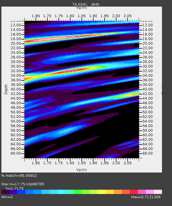
| Estimated Moho Depth: |
17.75 km |
| Estimated Crust Vp/Vs: |
1.72 |
| Assumed Crust Vp: |
6.391 km/s |
| Estimated Crust Vs: |
3.721 km/s |
| Estimated Crust Poisson's Ratio: |
0.24 |
|
| Radial Match: |
95.48802 % |
| Radial Bump: |
380 |
| Transverse Match: |
94.97441 % |
| Transverse Bump: |
399 |
| SOD ConfigId: |
2564 |
| Insert Time: |
2010-03-06 22:57:02.819 +0000 |
| GWidth: |
2.5 |
| Max Bumps: |
400 |
| Tol: |
0.001 |
|

Signal To Noise
| Channel | StoN | STA | LTA |
| TA:S04C: :BHN:20070401T20:52:17.450007Z | 0.84411466 | 1.6305543E-7 | 1.9316741E-7 |
| TA:S04C: :BHE:20070401T20:52:17.450007Z | 2.650891 | 5.4775745E-7 | 2.0663146E-7 |
| TA:S04C: :BHZ:20070401T20:52:17.450007Z | 8.147277 | 2.002626E-6 | 2.458031E-7 |
| Arrivals |
| Ps | 2.0 SECOND |
| PpPs | 7.4 SECOND |
| PsPs/PpSs | 9.4 SECOND |


