You are here: Home > Network List > TA - USArray Transportable Network (new EarthScope stations) Stations List
> Station S04C Ingram Canyon, Westley, CA, USA > Earthquake Result Viewer
S04C Ingram Canyon, Westley, CA, USA - Earthquake Result Viewer
| Earthquake location: |
Vanuatu Islands |
| Earthquake latitude/longitude: |
-20.8/169.4 |
| Earthquake time(UTC): |
2007/03/25 (084) 01:08:19 GMT |
| Earthquake Depth: |
35 km |
| Earthquake Magnitude: |
5.9 MB, 7.1 MS, 6.9 MW |
| Earthquake Catalog/Contributor: |
WHDF/NEIC |
|
| Network: |
TA USArray Transportable Network (new EarthScope stations) |
| Station: |
S04C Ingram Canyon, Westley, CA, USA |
| Lat/Lon: |
37.51 N/121.33 W |
| Elevation: |
310 m |
|
| Distance: |
87.2 deg |
| Az: |
48.153 deg |
| Baz: |
241.241 deg |
| Ray Param: |
0.043466873 |
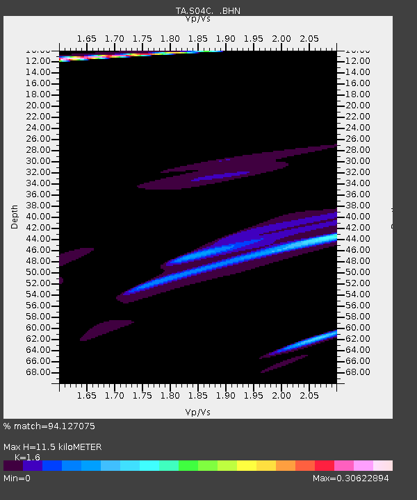
| Estimated Moho Depth: |
11.5 km |
| Estimated Crust Vp/Vs: |
1.60 |
| Assumed Crust Vp: |
6.391 km/s |
| Estimated Crust Vs: |
3.994 km/s |
| Estimated Crust Poisson's Ratio: |
0.18 |
|
| Radial Match: |
94.127075 % |
| Radial Bump: |
359 |
| Transverse Match: |
56.896168 % |
| Transverse Bump: |
400 |
| SOD ConfigId: |
2564 |
| Insert Time: |
2010-03-06 22:57:04.178 +0000 |
| GWidth: |
2.5 |
| Max Bumps: |
400 |
| Tol: |
0.001 |
|
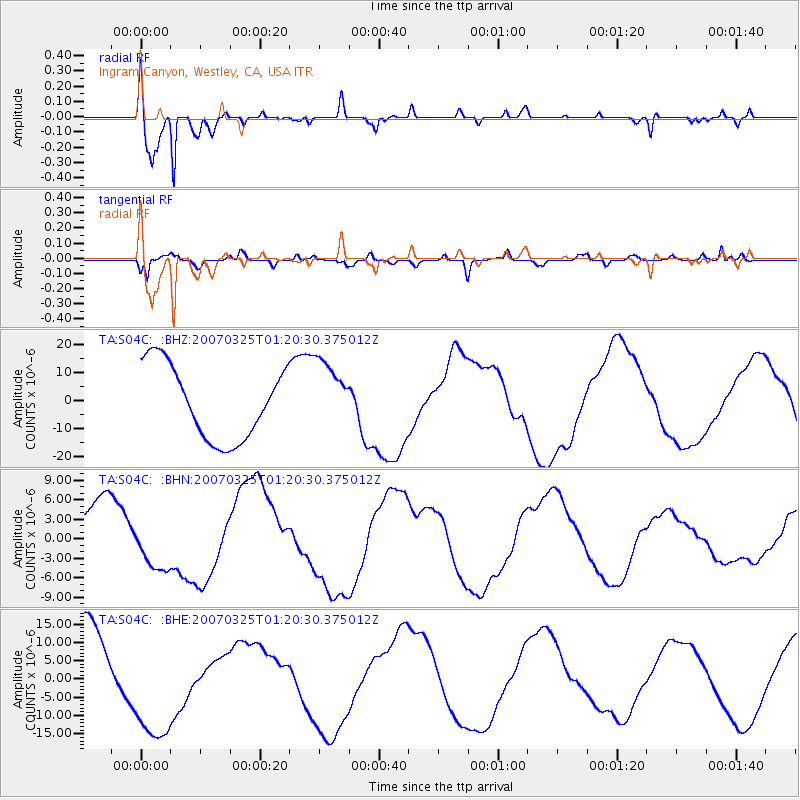
Signal To Noise
| Channel | StoN | STA | LTA |
| TA:S04C: :BHN:20070325T01:20:30.375012Z | 1.0448691 | 3.907597E-6 | 3.7397958E-6 |
| TA:S04C: :BHE:20070325T01:20:30.375012Z | 1.4510456 | 1.5740283E-5 | 1.0847545E-5 |
| TA:S04C: :BHZ:20070325T01:20:30.375012Z | 0.96829957 | 1.2652138E-5 | 1.30663475E-5 |
| Arrivals |
| Ps | 1.1 SECOND |
| PpPs | 4.6 SECOND |
| PsPs/PpSs | 5.7 SECOND |


