You are here: Home > Network List > TA - USArray Transportable Network (new EarthScope stations) Stations List
> Station S04C Ingram Canyon, Westley, CA, USA > Earthquake Result Viewer
S04C Ingram Canyon, Westley, CA, USA - Earthquake Result Viewer
| Earthquake location: |
East Of Kuril Islands |
| Earthquake latitude/longitude: |
46.2/154.5 |
| Earthquake time(UTC): |
2007/01/13 (013) 04:23:21 GMT |
| Earthquake Depth: |
10 km |
| Earthquake Magnitude: |
7.3 MB, 8.2 MS, 8.1 MW, 7.9 MW |
| Earthquake Catalog/Contributor: |
WHDF/NEIC |
|
| Network: |
TA USArray Transportable Network (new EarthScope stations) |
| Station: |
S04C Ingram Canyon, Westley, CA, USA |
| Lat/Lon: |
37.51 N/121.33 W |
| Elevation: |
310 m |
|
| Distance: |
60.5 deg |
| Az: |
65.39 deg |
| Baz: |
307.494 deg |
| Ray Param: |
0.06150575 |
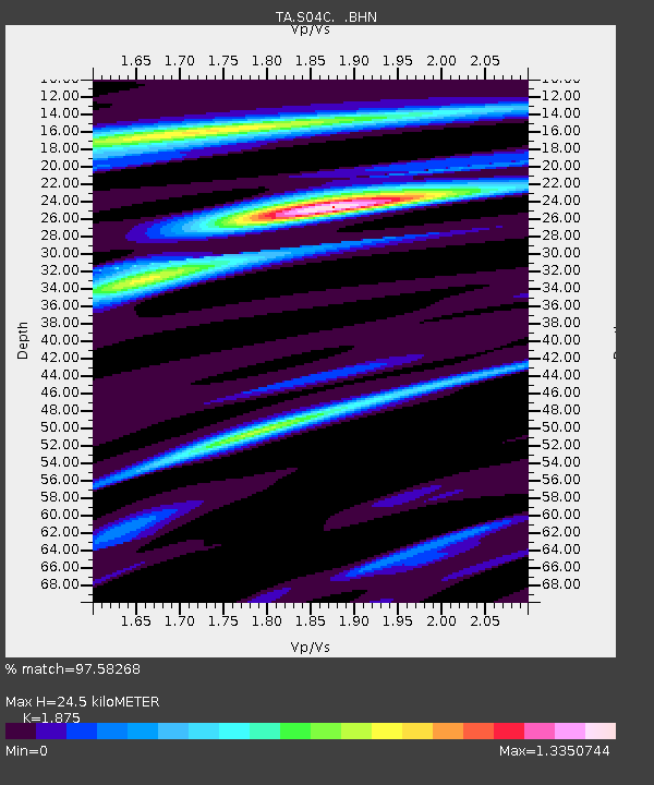
| Estimated Moho Depth: |
24.5 km |
| Estimated Crust Vp/Vs: |
1.88 |
| Assumed Crust Vp: |
6.391 km/s |
| Estimated Crust Vs: |
3.408 km/s |
| Estimated Crust Poisson's Ratio: |
0.30 |
|
| Radial Match: |
97.58268 % |
| Radial Bump: |
372 |
| Transverse Match: |
94.15079 % |
| Transverse Bump: |
400 |
| SOD ConfigId: |
2564 |
| Insert Time: |
2010-03-06 22:57:10.945 +0000 |
| GWidth: |
2.5 |
| Max Bumps: |
400 |
| Tol: |
0.001 |
|

Signal To Noise
| Channel | StoN | STA | LTA |
| TA:S04C: :BHN:20070113T04:32:59.975002Z | 4.896748 | 7.783554E-7 | 1.5895354E-7 |
| TA:S04C: :BHE:20070113T04:32:59.975002Z | 2.2740421 | 7.2603103E-7 | 3.1926893E-7 |
| TA:S04C: :BHZ:20070113T04:32:59.975002Z | 7.558757 | 2.3744767E-6 | 3.141359E-7 |
| Arrivals |
| Ps | 3.5 SECOND |
| PpPs | 11 SECOND |
| PsPs/PpSs | 14 SECOND |


