You are here: Home > Network List > TA - USArray Transportable Network (new EarthScope stations) Stations List
> Station S04C Ingram Canyon, Westley, CA, USA > Earthquake Result Viewer
S04C Ingram Canyon, Westley, CA, USA - Earthquake Result Viewer
| Earthquake location: |
Near Coast Of Peru |
| Earthquake latitude/longitude: |
-13.5/-76.7 |
| Earthquake time(UTC): |
2006/10/20 (293) 10:48:56 GMT |
| Earthquake Depth: |
23 km |
| Earthquake Magnitude: |
5.9 MB, 6.6 MS, 6.7 MW, 6.6 MW |
| Earthquake Catalog/Contributor: |
WHDF/NEIC |
|
| Network: |
TA USArray Transportable Network (new EarthScope stations) |
| Station: |
S04C Ingram Canyon, Westley, CA, USA |
| Lat/Lon: |
37.51 N/121.33 W |
| Elevation: |
310 m |
|
| Distance: |
65.8 deg |
| Az: |
322.204 deg |
| Baz: |
131.433 deg |
| Ray Param: |
0.058018304 |
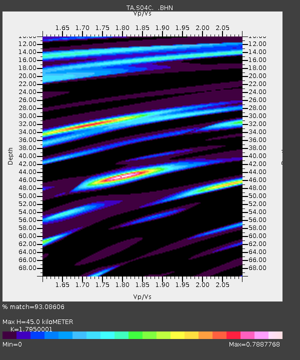
| Estimated Moho Depth: |
45.0 km |
| Estimated Crust Vp/Vs: |
1.80 |
| Assumed Crust Vp: |
6.391 km/s |
| Estimated Crust Vs: |
3.56 km/s |
| Estimated Crust Poisson's Ratio: |
0.27 |
|
| Radial Match: |
93.08606 % |
| Radial Bump: |
400 |
| Transverse Match: |
89.25323 % |
| Transverse Bump: |
400 |
| SOD ConfigId: |
2665 |
| Insert Time: |
2010-03-06 22:57:12.963 +0000 |
| GWidth: |
2.5 |
| Max Bumps: |
400 |
| Tol: |
0.001 |
|

Signal To Noise
| Channel | StoN | STA | LTA |
| TA:S04C: :BHN:20061020T10:59:08.075002Z | 1.5045747 | 2.0333074E-7 | 1.3514168E-7 |
| TA:S04C: :BHE:20061020T10:59:08.075002Z | 1.8997774 | 3.983064E-7 | 2.0965952E-7 |
| TA:S04C: :BHZ:20061020T10:59:08.075002Z | 1.5764686 | 9.553871E-7 | 6.060299E-7 |
| Arrivals |
| Ps | 5.8 SECOND |
| PpPs | 19 SECOND |
| PsPs/PpSs | 25 SECOND |


