You are here: Home > Network List > TA - USArray Transportable Network (new EarthScope stations) Stations List
> Station S04C Ingram Canyon, Westley, CA, USA > Earthquake Result Viewer
S04C Ingram Canyon, Westley, CA, USA - Earthquake Result Viewer
| Earthquake location: |
Vanuatu Islands |
| Earthquake latitude/longitude: |
-18.9/169.0 |
| Earthquake time(UTC): |
2006/10/03 (276) 18:03:14 GMT |
| Earthquake Depth: |
171 km |
| Earthquake Magnitude: |
5.9 MB, 6.3 MW, 6.3 MW |
| Earthquake Catalog/Contributor: |
WHDF/NEIC |
|
| Network: |
TA USArray Transportable Network (new EarthScope stations) |
| Station: |
S04C Ingram Canyon, Westley, CA, USA |
| Lat/Lon: |
37.51 N/121.33 W |
| Elevation: |
310 m |
|
| Distance: |
86.2 deg |
| Az: |
48.365 deg |
| Baz: |
242.862 deg |
| Ray Param: |
0.043848235 |
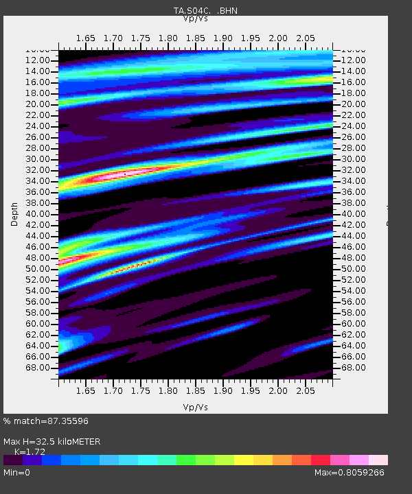
| Estimated Moho Depth: |
32.5 km |
| Estimated Crust Vp/Vs: |
1.72 |
| Assumed Crust Vp: |
6.391 km/s |
| Estimated Crust Vs: |
3.715 km/s |
| Estimated Crust Poisson's Ratio: |
0.24 |
|
| Radial Match: |
87.35596 % |
| Radial Bump: |
396 |
| Transverse Match: |
80.50434 % |
| Transverse Bump: |
400 |
| SOD ConfigId: |
2665 |
| Insert Time: |
2010-03-06 22:57:16.134 +0000 |
| GWidth: |
2.5 |
| Max Bumps: |
400 |
| Tol: |
0.001 |
|
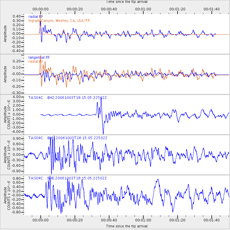
Signal To Noise
| Channel | StoN | STA | LTA |
| TA:S04C: :BHN:20061003T18:15:05.22502Z | 2.02513 | 1.6725566E-7 | 8.2590084E-8 |
| TA:S04C: :BHE:20061003T18:15:05.22502Z | 3.15857 | 2.9407758E-7 | 9.310466E-8 |
| TA:S04C: :BHZ:20061003T18:15:05.22502Z | 8.636514 | 9.768229E-7 | 1.1310384E-7 |
| Arrivals |
| Ps | 3.7 SECOND |
| PpPs | 14 SECOND |
| PsPs/PpSs | 17 SECOND |


