You are here: Home > Network List > GS - US Geological Survey Networks Stations List
> Station OK046 Pawnee, OK, Station 46 > Earthquake Result Viewer
OK046 Pawnee, OK, Station 46 - Earthquake Result Viewer
| Earthquake location: |
San Juan Province, Argentina |
| Earthquake latitude/longitude: |
-31.6/-68.8 |
| Earthquake time(UTC): |
2016/11/20 (325) 20:57:43 GMT |
| Earthquake Depth: |
116 km |
| Earthquake Magnitude: |
6.4 MWP, 6.5 MWB |
| Earthquake Catalog/Contributor: |
NEIC PDE/NEIC COMCAT |
|
| Network: |
GS US Geological Survey Networks |
| Station: |
OK046 Pawnee, OK, Station 46 |
| Lat/Lon: |
36.40 N/96.91 W |
| Elevation: |
294 m |
|
| Distance: |
72.6 deg |
| Az: |
336.502 deg |
| Baz: |
155.072 deg |
| Ray Param: |
0.053242557 |
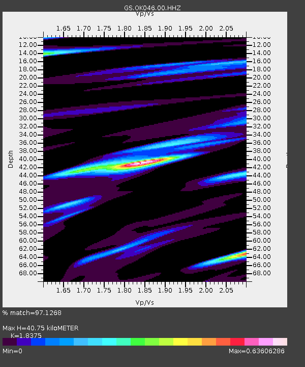
| Estimated Moho Depth: |
40.75 km |
| Estimated Crust Vp/Vs: |
1.84 |
| Assumed Crust Vp: |
6.483 km/s |
| Estimated Crust Vs: |
3.528 km/s |
| Estimated Crust Poisson's Ratio: |
0.29 |
|
| Radial Match: |
97.1268 % |
| Radial Bump: |
360 |
| Transverse Match: |
85.339714 % |
| Transverse Bump: |
400 |
| SOD ConfigId: |
1858631 |
| Insert Time: |
2016-12-04 21:01:13.252 +0000 |
| GWidth: |
2.5 |
| Max Bumps: |
400 |
| Tol: |
0.001 |
|

Signal To Noise
| Channel | StoN | STA | LTA |
| GS:OK046:00:HHZ:20161120T21:08:28.04897Z | 37.512783 | 6.77812E-6 | 1.8068828E-7 |
| GS:OK046:00:HH1:20161120T21:08:28.04897Z | 9.848711 | 3.1441666E-6 | 3.192465E-7 |
| GS:OK046:00:HH2:20161120T21:08:28.04897Z | 8.073235 | 1.6703475E-6 | 2.0689943E-7 |
| Arrivals |
| Ps | 5.4 SECOND |
| PpPs | 17 SECOND |
| PsPs/PpSs | 23 SECOND |


