You are here: Home > Network List > TA - USArray Transportable Network (new EarthScope stations) Stations List
> Station G03A Yamhill, OR, USA > Earthquake Result Viewer
G03A Yamhill, OR, USA - Earthquake Result Viewer
| Earthquake location: |
South Of Fiji Islands |
| Earthquake latitude/longitude: |
-26.0/-177.5 |
| Earthquake time(UTC): |
2007/12/09 (343) 07:28:20 GMT |
| Earthquake Depth: |
152 km |
| Earthquake Magnitude: |
7.0 MB, 7.8 MW, 7.7 MW |
| Earthquake Catalog/Contributor: |
WHDF/NEIC |
|
| Network: |
TA USArray Transportable Network (new EarthScope stations) |
| Station: |
G03A Yamhill, OR, USA |
| Lat/Lon: |
45.32 N/123.28 W |
| Elevation: |
208 m |
|
| Distance: |
86.4 deg |
| Az: |
35.004 deg |
| Baz: |
227.026 deg |
| Ray Param: |
0.043710385 |
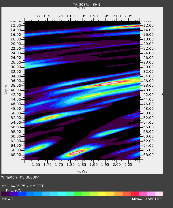
| Estimated Moho Depth: |
36.75 km |
| Estimated Crust Vp/Vs: |
1.98 |
| Assumed Crust Vp: |
6.566 km/s |
| Estimated Crust Vs: |
3.325 km/s |
| Estimated Crust Poisson's Ratio: |
0.33 |
|
| Radial Match: |
93.880394 % |
| Radial Bump: |
400 |
| Transverse Match: |
85.817604 % |
| Transverse Bump: |
400 |
| SOD ConfigId: |
2564 |
| Insert Time: |
2010-03-07 00:59:42.330 +0000 |
| GWidth: |
2.5 |
| Max Bumps: |
400 |
| Tol: |
0.001 |
|
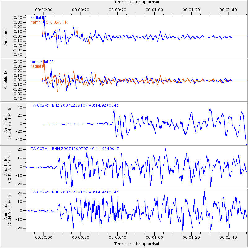
Signal To Noise
| Channel | StoN | STA | LTA |
| TA:G03A: :BHN:20071209T07:40:14.924004Z | 2.037268 | 6.957136E-7 | 3.414934E-7 |
| TA:G03A: :BHE:20071209T07:40:14.924004Z | 1.9657333 | 7.3567685E-7 | 3.742506E-7 |
| TA:G03A: :BHZ:20071209T07:40:14.924004Z | 3.4223769 | 1.5396814E-6 | 4.4988656E-7 |
| Arrivals |
| Ps | 5.6 SECOND |
| PpPs | 16 SECOND |
| PsPs/PpSs | 22 SECOND |


