
Station TA G03A - Yamhill, OR, USA
Network: TA - USArray Transportable Network (new EarthScope stations)
Nearby stations (2 deg radius)
| Station | Name | (Lat, Lon) | Start / End | Elevation |
| G03A | Yamhill, OR, USA | (45.32, -123.28) | 2006-07-15 / 2499-01-01 | 0.2 km |
| Crust2 Type: | L8,thin continental arc, Cordilleras, 0.5 km seds. |
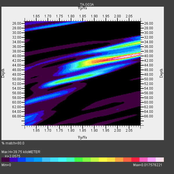
| Thickness Estimate: | 40 km |
| Thickness StdDev: | 3.1 km |
| Vp/Vs Estimate: | 2.06 |
| Vp/Vs StdDev: | 0.07 |
| Vs Estimate: | 3.191 km/s |
| Poisson's Ratio: | 0.35 |
| Peak Value: | 0.02 |
| Assumed Vp: | 6.566 km/s |
| Ps Weight: | 0.33333334 |
| PpPs Weight: | 0.33333334 |
| PsPs Weight: | 0.33333328 |
| Residual Complexity: | 0.653 |
| Nearby stations H: | +- |
| (2.0 deg) Vp/Vs: | +- |
15 with match > 90% ( 44.117645 %) and 34 with match > 80% ( 100.0 %) out of 34.
Download stack as xyz text file.
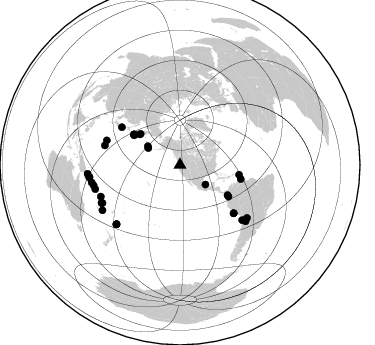
Azimuth Distribution of Events:
Prior Results for this Station
| Study | Thickness | Vp/Vs | Vp | Vs | Poissons Ratio | Extra |
| EARS | 40 km | 2.06 | 6.566 km/s | 3.191 km/s | 0.35 | |
| Crust2.0 | 34 km | 1.77 | 6.566 km/s | 3.707 km/s | 0.27 | L8,thin continental arc, Cordilleras, 0.5 km seds. |
| Global Maxima | 40 km | 2.06 | 6.566 km/s | 3.191 km/s | 0.35 | amp=0.017576221 |
| Local Maxima 1 | 34 km | 2.09 | 6.566 km/s | 3.142 km/s | 0.35 | amp=0.010672848 |
| Local Maxima 2 | 50 km | 1.77 | 6.566 km/s | 3.715 km/s | 0.26 | amp=0.008884405 |
| Local Maxima 3 | 43 km | 1.89 | 6.566 km/s | 3.47 km/s | 0.31 | amp=0.0060417936 |
| Local Maxima 4 | 26 km | 1.75 | 6.566 km/s | 3.763 km/s | 0.26 | amp=0.0043842294 |
| Predicted Arrivals for vertical incidence (zero ray parameter) | |
| Ps | 6.40 SECOND |
| PpPs | 18.51 SECOND |
| PsPs/PpSs | 24.91 SECOND |
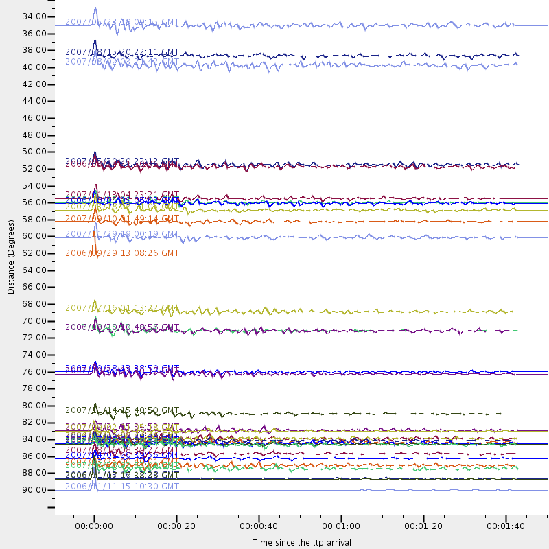
Events Processed for this Station
Download zip of receiver functions as SAC
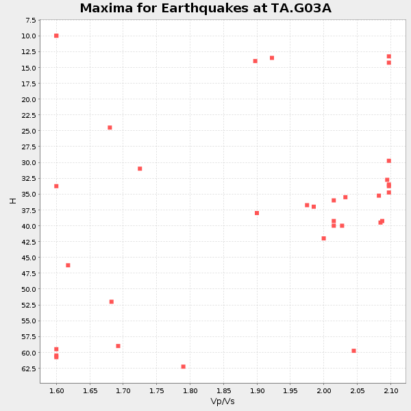
Plot maxima for each earthquake.
Events Used in the Stack
(34 events)| Radial Match | Distance | Baz | FERegion | Time | Lat/Lon | Depth | Magnitude |
| 99.967186 | 62.4 deg | 103.016 deg | Trinidad | 2006/09/29 13:08:26 GMT | (10.9, -61.8) | 53 km | 5.9 MB, 5.4 MS, 6.1 MW, 6.0 MW |
| 98.858055 | 92.9 deg | 264.47 deg | New Britain Region, P.N.G. | 2006/11/11 15:10:30 GMT | (-6.0, 148.6) | 47 km | 5.7 MB, 5.7 MS, 5.9 MW, 5.9 MW |
| 97.42928 | 91.4 deg | 262.292 deg | New Britain Region, P.N.G. | 2006/11/07 17:38:33 GMT | (-6.5, 151.2) | 10 km | 6.2 MB, 6.3 MS, 6.5 MW, 6.4 MW |
| 96.947784 | 72.1 deg | 131.909 deg | Near Coast Of Peru | 2007/08/15 23:40:57 GMT | (-13.4, -76.6) | 39 km | 6.7 MB, 7.9 MS, 8.0 MW, 7.5 ME |
| 96.60594 | 88.8 deg | 256.772 deg | Solomon Islands | 2007/04/01 20:39:56 GMT | (-8.5, 157.0) | 10 km | 6.8 MB, 7.9 MS, 8.1 MW, 7.7 ME |
| 96.429756 | 91.3 deg | 262.339 deg | New Britain Region, P.N.G. | 2006/11/13 16:12:28 GMT | (-6.4, 151.2) | 11 km | 6.1 MB, 5.9 MS, 6.2 MW, 6.1 MW |
| 95.21754 | 54.8 deg | 302.687 deg | East Of Kuril Islands | 2007/01/13 04:23:21 GMT | (46.2, 154.5) | 10 km | 7.3 MB, 8.2 MS, 8.1 MW, 7.9 MW |
| 95.18564 | 55.3 deg | 303.603 deg | Kuril Islands | 2006/11/15 11:14:13 GMT | (46.6, 153.3) | 10 km | 6.5 MB, 7.8 MS, 8.3 MW, 7.9 MW |
| 94.76138 | 82.9 deg | 131.463 deg | Northern Chile | 2007/11/14 15:40:50 GMT | (-22.2, -69.9) | 40 km | 6.7 MB, 7.4 MS, 7.7 MW, 7.4 ME |
| 93.880394 | 86.4 deg | 227.026 deg | South Of Fiji Islands | 2007/12/09 07:28:20 GMT | (-26.0, -177.5) | 152 km | 7.0 MB, 7.8 MW, 7.7 MW |
| 93.56126 | 85.2 deg | 248.351 deg | Santa Cruz Islands | 2007/09/02 01:05:18 GMT | (-11.6, 165.8) | 35 km | 5.9 MB, 7.3 MS, 7.2 MW, 6.9 ME |
| 91.27122 | 59.9 deg | 99.327 deg | Windward Islands | 2007/11/29 19:00:19 GMT | (15.0, -61.3) | 148 km | 6.9 MB, 7.4 MW, 7.4 MW |
| 90.926506 | 86.9 deg | 244.315 deg | Vanuatu Islands | 2007/08/01 17:08:51 GMT | (-15.6, 167.7) | 120 km | 6.2 MB, 7.2 MW, 7.2 MW |
| 90.74901 | 57.8 deg | 123.005 deg | Near West Coast Of Colombia | 2007/09/10 01:49:14 GMT | (3.0, -78.0) | 31 km | 6.1 MB, 6.7 MS, 6.8 MW |
| 90.30972 | 77.4 deg | 288.487 deg | Volcano Islands, Japan Region | 2007/09/28 13:38:59 GMT | (22.0, 142.7) | 276 km | 6.7 MB, 7.4 MW, 7.4 MW |
| 89.165634 | 69.6 deg | 302.91 deg | Near West Coast Of Honshu, Japan | 2007/07/16 01:13:22 GMT | (37.5, 138.4) | 12 km | 6.5 MB, 6.4 MS, 6.6 MW, 6.5 MW |
| 89.14888 | 86.2 deg | 130.559 deg | Chile-Argentina Border Region | 2006/08/25 00:44:46 GMT | (-24.4, -67.0) | 184 km | 5.9 MB, 6.6 MW, 6.6 MW |
| 88.48615 | 88.1 deg | 254.102 deg | Solomon Islands | 2007/08/16 08:39:27 GMT | (-9.8, 159.5) | 10 km | 6.1 MB, 6.7 MS, 6.4 MW |
| 87.66177 | 36.1 deg | 297.967 deg | Andreanof Islands, Aleutian Is. | 2007/08/15 20:22:11 GMT | (50.3, -177.5) | 9.0 km | 6.3 MB, 6.2 MS, 6.4 MW, 5.9 ML |
| 87.425674 | 56.3 deg | 122.387 deg | South Of Panama | 2007/03/18 02:11:05 GMT | (4.6, -78.5) | 8.0 km | 6.4 MB, 5.7 MS, 6.2 MW, 6.1 MW |
| 87.113075 | 50.4 deg | 308.125 deg | Kamchatka Peninsula, Russia | 2007/05/30 20:22:12 GMT | (52.1, 157.3) | 116 km | 6.4 MB, 6.4 MW, 6.4 MW |
| 86.18712 | 55.4 deg | 303.488 deg | Kuril Islands | 2006/10/01 09:06:02 GMT | (46.5, 153.2) | 19 km | 6.1 MB, 6.4 MS, 6.6 MW, 6.5 MW |
| 85.834496 | 85.1 deg | 128.297 deg | Jujuy Province, Argentina | 2007/07/21 15:34:52 GMT | (-22.2, -65.8) | 290 km | 5.8 MB, 6.4 MW, 6.3 MW |
| 85.555336 | 86.8 deg | 227.02 deg | South Of Fiji Islands | 2007/07/18 00:07:35 GMT | (-26.3, -177.7) | 10 km | 5.8 MB, 5.9 MS, 6.1 MW, 6.0 MW |
| 85.205215 | 86.7 deg | 227.075 deg | South Of Fiji Islands | 2007/07/17 09:39:27 GMT | (-26.2, -177.7) | 10 km | 5.7 MB, 6.0 MS, 6.1 MW, 6.0 MW |
| 84.468155 | 86.2 deg | 243.787 deg | Vanuatu Islands | 2007/07/15 09:27:34 GMT | (-15.4, 168.6) | 8.0 km | 6.0 MB, 5.8 MS, 6.1 MW, 6.0 MW |
| 84.03142 | 37.4 deg | 300.174 deg | Andreanof Islands, Aleutian Is. | 2007/08/02 03:21:42 GMT | (51.3, -180.0) | 21 km | 6.3 MB, 6.6 MS, 6.7 MW, 6.6 MW |
| 83.28509 | 77.7 deg | 284.399 deg | Mariana Islands | 2007/10/31 03:30:17 GMT | (18.9, 145.4) | 223 km | 6.2 MB, 7.2 MW, 7.2 MW |
| 82.96565 | 32.1 deg | 127.719 deg | Gulf Of Mexico | 2007/05/23 19:09:15 GMT | (21.9, -96.4) | 10 km | 5.6 MW, 4.8 MS, 5.4 MB |
| 82.7041 | 90.1 deg | 258.826 deg | Solomon Islands | 2007/06/28 02:52:09 GMT | (-8.0, 154.6) | 10 km | 6.3 MB, 6.7 MS, 6.7 MW, 6.7 MW |
| 82.3794 | 87.0 deg | 244.109 deg | Vanuatu Islands | 2006/08/07 22:18:54 GMT | (-15.8, 167.8) | 141 km | 6.0 MB, 6.8 MW, 6.8 MW |
| 81.68627 | 50.7 deg | 306.891 deg | Near East Coast Of Kamchatka | 2006/08/24 21:50:36 GMT | (51.1, 157.5) | 43 km | 5.9 MB, 6.2 MS, 6.5 MW, 6.5 MW |
| 80.36869 | 89.6 deg | 239.834 deg | Vanuatu Islands | 2007/03/25 00:40:01 GMT | (-20.6, 169.4) | 34 km | 6.5 MB, 7.0 MS, 7.1 MW, 7.1 MW |
| 80.203 | 72.1 deg | 132.013 deg | Near Coast Of Peru | 2006/10/20 10:48:56 GMT | (-13.5, -76.7) | 23 km | 5.9 MB, 6.6 MS, 6.7 MW, 6.6 MW |
Losers
(0 events)| Radial Match | Distance | Baz | FERegion | Time | Lat/Lon | Depth | Magnitude | Reason |
