You are here: Home > Network List > TA - USArray Transportable Network (new EarthScope stations) Stations List
> Station G03A Yamhill, OR, USA > Earthquake Result Viewer
G03A Yamhill, OR, USA - Earthquake Result Viewer
| Earthquake location: |
Mariana Islands |
| Earthquake latitude/longitude: |
18.9/145.4 |
| Earthquake time(UTC): |
2007/10/31 (304) 03:30:17 GMT |
| Earthquake Depth: |
223 km |
| Earthquake Magnitude: |
6.2 MB, 7.2 MW, 7.2 MW |
| Earthquake Catalog/Contributor: |
WHDF/NEIC |
|
| Network: |
TA USArray Transportable Network (new EarthScope stations) |
| Station: |
G03A Yamhill, OR, USA |
| Lat/Lon: |
45.32 N/123.28 W |
| Elevation: |
208 m |
|
| Distance: |
77.7 deg |
| Az: |
46.207 deg |
| Baz: |
284.399 deg |
| Ray Param: |
0.049534533 |
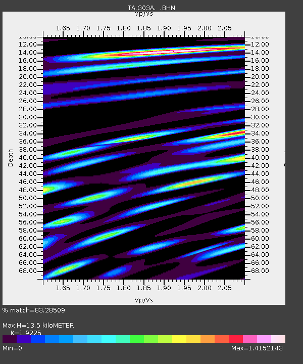
| Estimated Moho Depth: |
13.5 km |
| Estimated Crust Vp/Vs: |
1.92 |
| Assumed Crust Vp: |
6.566 km/s |
| Estimated Crust Vs: |
3.415 km/s |
| Estimated Crust Poisson's Ratio: |
0.31 |
|
| Radial Match: |
83.28509 % |
| Radial Bump: |
400 |
| Transverse Match: |
70.42232 % |
| Transverse Bump: |
400 |
| SOD ConfigId: |
2564 |
| Insert Time: |
2010-03-07 00:59:48.319 +0000 |
| GWidth: |
2.5 |
| Max Bumps: |
400 |
| Tol: |
0.001 |
|

Signal To Noise
| Channel | StoN | STA | LTA |
| TA:G03A: :BHN:20071031T03:41:18.675015Z | 1.9306631 | 7.35783E-7 | 3.8110375E-7 |
| TA:G03A: :BHE:20071031T03:41:18.675015Z | 4.1305175 | 1.6054923E-6 | 3.8869035E-7 |
| TA:G03A: :BHZ:20071031T03:41:18.675015Z | 10.455704 | 3.742488E-6 | 3.5793744E-7 |
| Arrivals |
| Ps | 2.0 SECOND |
| PpPs | 5.8 SECOND |
| PsPs/PpSs | 7.8 SECOND |


