You are here: Home > Network List > TA - USArray Transportable Network (new EarthScope stations) Stations List
> Station G03A Yamhill, OR, USA > Earthquake Result Viewer
G03A Yamhill, OR, USA - Earthquake Result Viewer
| Earthquake location: |
Vanuatu Islands |
| Earthquake latitude/longitude: |
-15.6/167.7 |
| Earthquake time(UTC): |
2007/08/01 (213) 17:08:51 GMT |
| Earthquake Depth: |
120 km |
| Earthquake Magnitude: |
6.2 MB, 7.2 MW, 7.2 MW |
| Earthquake Catalog/Contributor: |
WHDF/NEIC |
|
| Network: |
TA USArray Transportable Network (new EarthScope stations) |
| Station: |
G03A Yamhill, OR, USA |
| Lat/Lon: |
45.32 N/123.28 W |
| Elevation: |
208 m |
|
| Distance: |
86.9 deg |
| Az: |
41.289 deg |
| Baz: |
244.315 deg |
| Ray Param: |
0.043446675 |
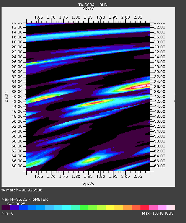
| Estimated Moho Depth: |
35.25 km |
| Estimated Crust Vp/Vs: |
2.08 |
| Assumed Crust Vp: |
6.566 km/s |
| Estimated Crust Vs: |
3.153 km/s |
| Estimated Crust Poisson's Ratio: |
0.35 |
|
| Radial Match: |
90.926506 % |
| Radial Bump: |
400 |
| Transverse Match: |
77.32322 % |
| Transverse Bump: |
400 |
| SOD ConfigId: |
2564 |
| Insert Time: |
2010-03-07 01:00:03.361 +0000 |
| GWidth: |
2.5 |
| Max Bumps: |
400 |
| Tol: |
0.001 |
|

Signal To Noise
| Channel | StoN | STA | LTA |
| TA:G03A: :BHN:20070801T17:20:51.600012Z | 1.3113711 | 4.064111E-7 | 3.0991313E-7 |
| TA:G03A: :BHE:20070801T17:20:51.600012Z | 1.7834044 | 5.408088E-7 | 3.0324517E-7 |
| TA:G03A: :BHZ:20070801T17:20:51.600012Z | 2.7665944 | 8.837846E-7 | 3.1944856E-7 |
| Arrivals |
| Ps | 5.9 SECOND |
| PpPs | 16 SECOND |
| PsPs/PpSs | 22 SECOND |


