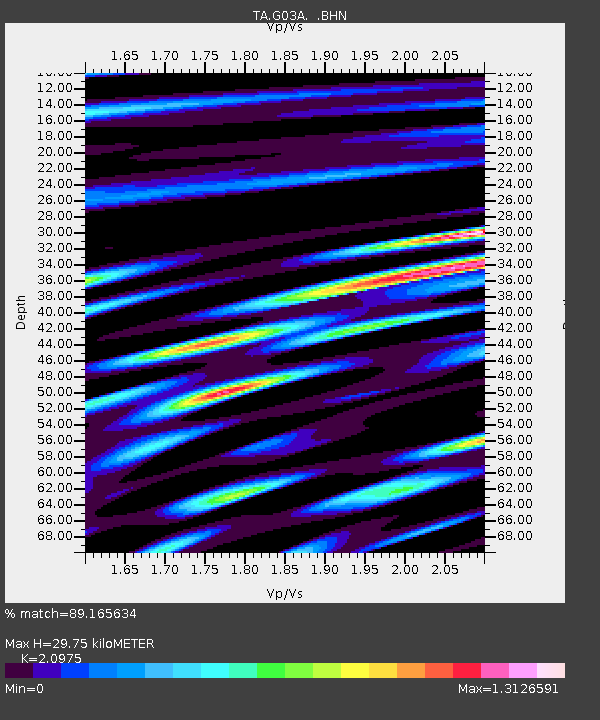
G03A Yamhill, OR, USA - Earthquake Result Viewer

Earthquake location: Near West Coast Of Honshu, Japan
Earthquake latitude/longitude: 37.5/138.4
Earthquake time(UTC): 2007/07/16 (197) 01:13:22 GMT
Earthquake Depth: 12 km
Earthquake Magnitude: 6.5 MB, 6.4 MS, 6.6 MW, 6.5 MW
Earthquake Catalog/Contributor: WHDF/NEIC
Network: TA USArray Transportable Network (new EarthScope stations)
Station: G03A Yamhill, OR, USA
Lat/Lon: 45.32 N/123.28 W
Elevation: 208 m
Distance: 69.6 deg
Az: 48.172 deg
Baz: 302.91 deg
Ray Param: 0.05556118
Estimated Moho Depth: 29.75 km
Estimated Crust Vp/Vs: 2.10
Assumed Crust Vp: 6.566 km/s
Estimated Crust Vs: 3.13 km/s
Estimated Crust Poisson's Ratio: 0.35
Radial Match: 89.165634 %
Radial Bump: 400
Transverse Match: 80.448425 %
Transverse Bump: 400
SOD ConfigId: 2564
Insert Time: 2010-03-07 01:00:10.604 +0000
GWidth: 2.5
Max Bumps: 400
Tol: 0.001

Signal To Noise

ChannelStoNSTALTA
TA:G03A: :BHN:20070716T01:23:59.799016Z3.37319454.4979527E-71.33344E-7
TA:G03A: :BHE:20070716T01:23:59.799016Z4.6202638.8421206E-71.91377E-7
TA:G03A: :BHZ:20070716T01:23:59.799016Z13.2649762.180019E-61.6434399E-7
Arrivals
Ps5.1 SECOND
PpPs14 SECOND
PsPs/PpSs19 SECOND