You are here: Home > Network List > TA - USArray Transportable Network (new EarthScope stations) Stations List
> Station G03A Yamhill, OR, USA > Earthquake Result Viewer
G03A Yamhill, OR, USA - Earthquake Result Viewer
| Earthquake location: |
Vanuatu Islands |
| Earthquake latitude/longitude: |
-15.4/168.6 |
| Earthquake time(UTC): |
2007/07/15 (196) 09:27:34 GMT |
| Earthquake Depth: |
8.0 km |
| Earthquake Magnitude: |
6.0 MB, 5.8 MS, 6.1 MW, 6.0 MW |
| Earthquake Catalog/Contributor: |
WHDF/NEIC |
|
| Network: |
TA USArray Transportable Network (new EarthScope stations) |
| Station: |
G03A Yamhill, OR, USA |
| Lat/Lon: |
45.32 N/123.28 W |
| Elevation: |
208 m |
|
| Distance: |
86.2 deg |
| Az: |
41.014 deg |
| Baz: |
243.787 deg |
| Ray Param: |
0.044246517 |
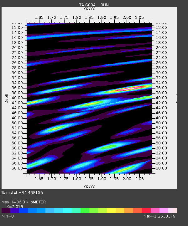
| Estimated Moho Depth: |
36.0 km |
| Estimated Crust Vp/Vs: |
2.02 |
| Assumed Crust Vp: |
6.566 km/s |
| Estimated Crust Vs: |
3.259 km/s |
| Estimated Crust Poisson's Ratio: |
0.34 |
|
| Radial Match: |
84.468155 % |
| Radial Bump: |
400 |
| Transverse Match: |
83.086075 % |
| Transverse Bump: |
400 |
| SOD ConfigId: |
2564 |
| Insert Time: |
2010-03-07 01:00:12.383 +0000 |
| GWidth: |
2.5 |
| Max Bumps: |
400 |
| Tol: |
0.001 |
|

Signal To Noise
| Channel | StoN | STA | LTA |
| TA:G03A: :BHN:20070715T09:39:44.599019Z | 3.9472537 | 4.9371675E-7 | 1.2507854E-7 |
| TA:G03A: :BHE:20070715T09:39:44.599019Z | 4.49985 | 6.9950636E-7 | 1.5545105E-7 |
| TA:G03A: :BHZ:20070715T09:39:44.599019Z | 19.061369 | 2.3419257E-6 | 1.228624E-7 |
| Arrivals |
| Ps | 5.7 SECOND |
| PpPs | 16 SECOND |
| PsPs/PpSs | 22 SECOND |


