You are here: Home > Network List > TA - USArray Transportable Network (new EarthScope stations) Stations List
> Station G03A Yamhill, OR, USA > Earthquake Result Viewer
G03A Yamhill, OR, USA - Earthquake Result Viewer
| Earthquake location: |
Solomon Islands |
| Earthquake latitude/longitude: |
-8.0/154.6 |
| Earthquake time(UTC): |
2007/06/28 (179) 02:52:09 GMT |
| Earthquake Depth: |
10 km |
| Earthquake Magnitude: |
6.3 MB, 6.7 MS, 6.7 MW, 6.7 MW |
| Earthquake Catalog/Contributor: |
WHDF/NEIC |
|
| Network: |
TA USArray Transportable Network (new EarthScope stations) |
| Station: |
G03A Yamhill, OR, USA |
| Lat/Lon: |
45.32 N/123.28 W |
| Elevation: |
208 m |
|
| Distance: |
90.1 deg |
| Az: |
44.337 deg |
| Baz: |
258.826 deg |
| Ray Param: |
0.041698866 |
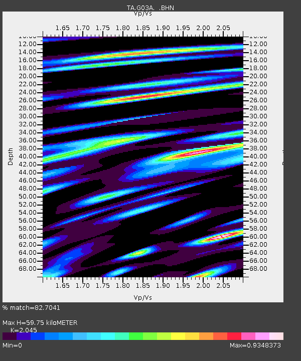
| Estimated Moho Depth: |
59.75 km |
| Estimated Crust Vp/Vs: |
2.05 |
| Assumed Crust Vp: |
6.566 km/s |
| Estimated Crust Vs: |
3.211 km/s |
| Estimated Crust Poisson's Ratio: |
0.34 |
|
| Radial Match: |
82.7041 % |
| Radial Bump: |
400 |
| Transverse Match: |
67.450455 % |
| Transverse Bump: |
400 |
| SOD ConfigId: |
2564 |
| Insert Time: |
2010-03-07 01:00:14.308 +0000 |
| GWidth: |
2.5 |
| Max Bumps: |
400 |
| Tol: |
0.001 |
|

Signal To Noise
| Channel | StoN | STA | LTA |
| TA:G03A: :BHN:20070628T03:04:38.050024Z | 1.9175043 | 3.0034036E-7 | 1.5663088E-7 |
| TA:G03A: :BHE:20070628T03:04:38.050024Z | 3.4970655 | 4.9292436E-7 | 1.409537E-7 |
| TA:G03A: :BHZ:20070628T03:04:38.050024Z | 9.514442 | 1.3284086E-6 | 1.3962023E-7 |
| Arrivals |
| Ps | 9.7 SECOND |
| PpPs | 27 SECOND |
| PsPs/PpSs | 37 SECOND |


