You are here: Home > Network List > TA - USArray Transportable Network (new EarthScope stations) Stations List
> Station G03A Yamhill, OR, USA > Earthquake Result Viewer
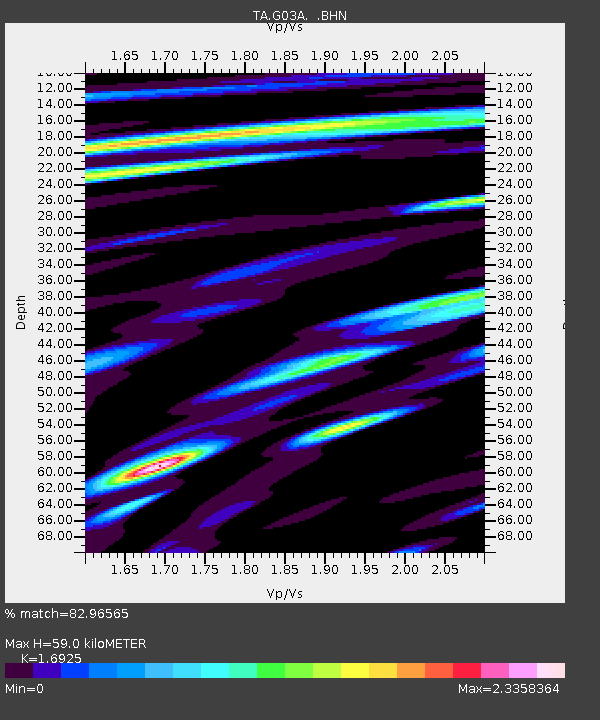
G03A Yamhill, OR, USA - Earthquake Result Viewer
| Earthquake location: |
Gulf Of Mexico |
| Earthquake latitude/longitude: |
21.9/-96.4 |
| Earthquake time(UTC): |
2007/05/23 (143) 19:09:15 GMT |
| Earthquake Depth: |
10 km |
| Earthquake Magnitude: |
5.6 MW, 4.8 MS, 5.4 MB |
| Earthquake Catalog/Contributor: |
WHDF/NEIC |
|
| Network: |
TA USArray Transportable Network (new EarthScope stations) |
| Station: |
G03A Yamhill, OR, USA |
| Lat/Lon: |
45.32 N/123.28 W |
| Elevation: |
208 m |
|
| Distance: |
32.1 deg |
| Az: |
323.062 deg |
| Baz: |
127.719 deg |
| Ray Param: |
0.07878919 |
| Estimated Moho Depth: |
59.0 km |
| Estimated Crust Vp/Vs: |
1.69 |
| Assumed Crust Vp: |
6.566 km/s |
| Estimated Crust Vs: |
3.88 km/s |
| Estimated Crust Poisson's Ratio: |
0.23 |
|
| Radial Match: |
82.96565 % |
| Radial Bump: |
400 |
| Transverse Match: |
74.22406 % |
| Transverse Bump: |
400 |
| SOD ConfigId: |
2564 |
| Insert Time: |
2010-03-07 01:00:18.407 +0000 |
| GWidth: |
2.5 |
| Max Bumps: |
400 |
| Tol: |
0.001 |
|

Signal To Noise
| Channel | StoN | STA | LTA |
| TA:G03A: :BHN:20070523T19:15:11.774012Z | 6.7571263 | 8.8572085E-7 | 1.3107952E-7 |
| TA:G03A: :BHE:20070523T19:15:11.774012Z | 8.0968 | 1.2206667E-6 | 1.5075915E-7 |
| TA:G03A: :BHZ:20070523T19:15:11.774012Z | 17.533875 | 2.1458306E-6 | 1.22382E-7 |
| Arrivals |
| Ps | 6.8 SECOND |
| PpPs | 22 SECOND |
| PsPs/PpSs | 29 SECOND |


