You are here: Home > Network List > TA - USArray Transportable Network (new EarthScope stations) Stations List
> Station G03A Yamhill, OR, USA > Earthquake Result Viewer
G03A Yamhill, OR, USA - Earthquake Result Viewer
| Earthquake location: |
Vanuatu Islands |
| Earthquake latitude/longitude: |
-20.6/169.4 |
| Earthquake time(UTC): |
2007/03/25 (084) 00:40:01 GMT |
| Earthquake Depth: |
34 km |
| Earthquake Magnitude: |
6.5 MB, 7.0 MS, 7.1 MW, 7.1 MW |
| Earthquake Catalog/Contributor: |
WHDF/NEIC |
|
| Network: |
TA USArray Transportable Network (new EarthScope stations) |
| Station: |
G03A Yamhill, OR, USA |
| Lat/Lon: |
45.32 N/123.28 W |
| Elevation: |
208 m |
|
| Distance: |
89.6 deg |
| Az: |
40.635 deg |
| Baz: |
239.834 deg |
| Ray Param: |
0.041726403 |
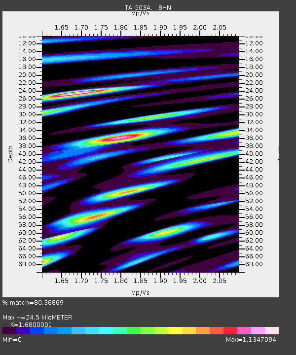
| Estimated Moho Depth: |
24.5 km |
| Estimated Crust Vp/Vs: |
1.68 |
| Assumed Crust Vp: |
6.566 km/s |
| Estimated Crust Vs: |
3.908 km/s |
| Estimated Crust Poisson's Ratio: |
0.23 |
|
| Radial Match: |
80.36869 % |
| Radial Bump: |
400 |
| Transverse Match: |
71.91322 % |
| Transverse Bump: |
400 |
| SOD ConfigId: |
2564 |
| Insert Time: |
2010-03-07 01:00:22.125 +0000 |
| GWidth: |
2.5 |
| Max Bumps: |
400 |
| Tol: |
0.001 |
|

Signal To Noise
| Channel | StoN | STA | LTA |
| TA:G03A: :BHN:20070325T00:52:24.675002Z | 1.4013063 | 1.0795126E-6 | 7.703616E-7 |
| TA:G03A: :BHE:20070325T00:52:24.675002Z | 2.0766866 | 1.7384821E-6 | 8.371422E-7 |
| TA:G03A: :BHZ:20070325T00:52:24.675002Z | 6.1405997 | 4.923533E-6 | 8.0180007E-7 |
| Arrivals |
| Ps | 2.6 SECOND |
| PpPs | 9.8 SECOND |
| PsPs/PpSs | 12 SECOND |


