You are here: Home > Network List > TA - USArray Transportable Network (new EarthScope stations) Stations List
> Station B09A Rice, WA, USA > Earthquake Result Viewer
B09A Rice, WA, USA - Earthquake Result Viewer
| Earthquake location: |
Andreanof Islands, Aleutian Is. |
| Earthquake latitude/longitude: |
51.4/-179.0 |
| Earthquake time(UTC): |
2007/12/21 (355) 07:24:34 GMT |
| Earthquake Depth: |
30 km |
| Earthquake Magnitude: |
6.1 MB, 6.2 MW, 6.3 ML |
| Earthquake Catalog/Contributor: |
WHDF/NEIC |
|
| Network: |
TA USArray Transportable Network (new EarthScope stations) |
| Station: |
B09A Rice, WA, USA |
| Lat/Lon: |
48.42 N/118.15 W |
| Elevation: |
630 m |
|
| Distance: |
38.3 deg |
| Az: |
69.74 deg |
| Baz: |
297.991 deg |
| Ray Param: |
0.07557779 |
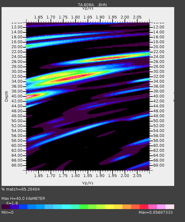
| Estimated Moho Depth: |
40.0 km |
| Estimated Crust Vp/Vs: |
1.60 |
| Assumed Crust Vp: |
6.419 km/s |
| Estimated Crust Vs: |
4.012 km/s |
| Estimated Crust Poisson's Ratio: |
0.18 |
|
| Radial Match: |
85.28484 % |
| Radial Bump: |
400 |
| Transverse Match: |
71.84706 % |
| Transverse Bump: |
400 |
| SOD ConfigId: |
2564 |
| Insert Time: |
2010-03-07 01:00:43.390 +0000 |
| GWidth: |
2.5 |
| Max Bumps: |
400 |
| Tol: |
0.001 |
|

Signal To Noise
| Channel | StoN | STA | LTA |
| TA:B09A: :BHN:20071221T07:31:22.12501Z | 3.2793884 | 8.3671927E-7 | 2.5514493E-7 |
| TA:B09A: :BHE:20071221T07:31:22.12501Z | 3.2019548 | 7.633816E-7 | 2.3841109E-7 |
| TA:B09A: :BHZ:20071221T07:31:22.12501Z | 5.300054 | 1.8369994E-6 | 3.4660013E-7 |
| Arrivals |
| Ps | 4.1 SECOND |
| PpPs | 15 SECOND |
| PsPs/PpSs | 19 SECOND |


