
Station TA B09A - Rice, WA, USA
Network: TA - USArray Transportable Network (new EarthScope stations)
Nearby stations (2 deg radius)
| Station | Name | (Lat, Lon) | Start / End | Elevation |
| B09A | Rice, WA, USA | (48.42, -118.15) | 2006-09-01 / 2499-01-01 | 0.6 km |
| Crust2 Type: | Q2,orogen/39km no ice, Appalachians, North Andes, 0.5 km seds. |
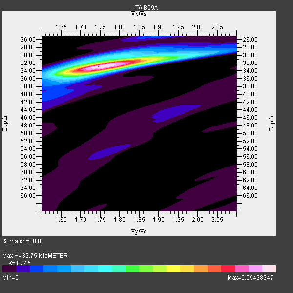
| Thickness Estimate: | 33 km |
| Thickness StdDev: | 0.2 km |
| Vp/Vs Estimate: | 1.75 |
| Vp/Vs StdDev: | 0.01 |
| Vs Estimate: | 3.679 km/s |
| Poisson's Ratio: | 0.26 |
| Peak Value: | 0.05 |
| Assumed Vp: | 6.419 km/s |
| Ps Weight: | 0.33333334 |
| PpPs Weight: | 0.33333334 |
| PsPs Weight: | 0.33333328 |
| Residual Complexity: | 0.328 |
| Nearby stations H: | +- |
| (2.0 deg) Vp/Vs: | +- |
22 with match > 90% ( 56.410255 %) and 39 with match > 80% ( 100.0 %) out of 39.
Download stack as xyz text file.
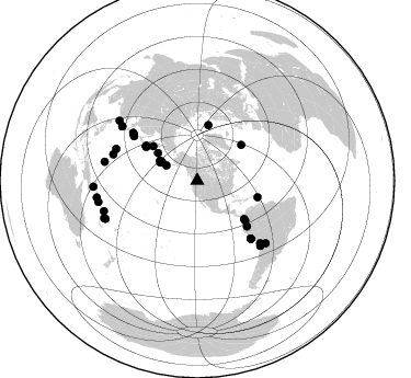
Azimuth Distribution of Events:
Prior Results for this Station
| Study | Thickness | Vp/Vs | Vp | Vs | Poissons Ratio | Extra |
| EARS | 33 km | 1.75 | 6.419 km/s | 3.679 km/s | 0.26 | |
| Crust2.0 | 39 km | 1.75 | 6.419 km/s | 3.659 km/s | 0.26 | Q2,orogen/39km no ice, Appalachians, North Andes, 0.5 km seds. |
| Global Maxima | 33 km | 1.75 | 6.419 km/s | 3.679 km/s | 0.26 | amp=0.05438947 |
| Local Maxima 1 | 34 km | 1.76 | 6.419 km/s | 3.642 km/s | 0.26 | amp=0.019426122 |
| Local Maxima 2 | 30 km | 1.87 | 6.419 km/s | 3.442 km/s | 0.30 | amp=0.009486701 |
| Local Maxima 3 | 25 km | 1.88 | 6.419 km/s | 3.405 km/s | 0.30 | amp=0.007753251 |
| Local Maxima 4 | 31 km | 1.74 | 6.419 km/s | 3.695 km/s | 0.25 | amp=0.0055336864 |
| Predicted Arrivals for vertical incidence (zero ray parameter) | |
| Ps | 3.80 SECOND |
| PpPs | 14.00 SECOND |
| PsPs/PpSs | 17.81 SECOND |
Events Processed for this Station
Download zip of receiver functions as SAC
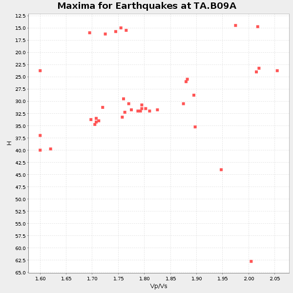
Plot maxima for each earthquake.
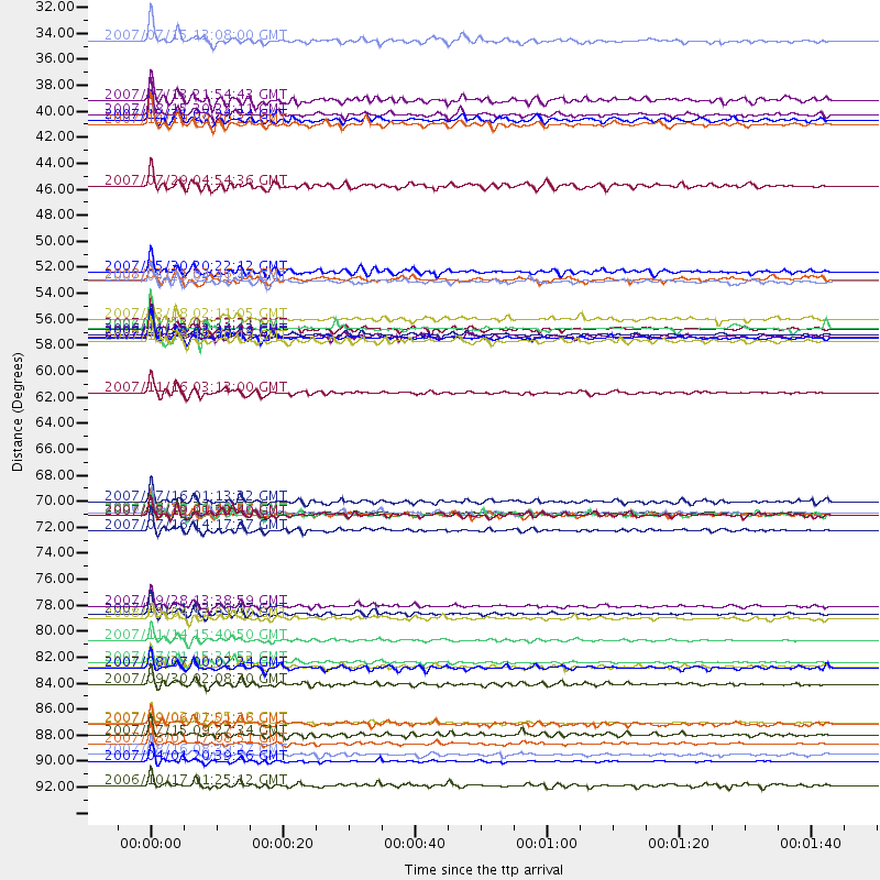
Events Used in the Stack
(39 events)| Radial Match | Distance | Baz | FERegion | Time | Lat/Lon | Depth | Magnitude |
| 98.63579 | 89.6 deg | 252.008 deg | Santa Cruz Islands | 2007/09/02 01:05:18 GMT | (-11.6, 165.8) | 35 km | 5.9 MB, 7.3 MS, 7.2 MW, 6.9 ME |
| 97.739174 | 71.7 deg | 137.178 deg | Near Coast Of Peru | 2007/08/15 23:40:57 GMT | (-13.4, -76.6) | 39 km | 6.7 MB, 7.9 MS, 8.0 MW, 7.5 ME |
| 97.587524 | 92.8 deg | 260.541 deg | Solomon Islands | 2007/04/01 20:39:56 GMT | (-8.5, 157.0) | 10 km | 6.8 MB, 7.9 MS, 8.1 MW, 7.7 ME |
| 97.53682 | 56.5 deg | 304.266 deg | Kuril Islands | 2006/11/15 11:14:13 GMT | (46.6, 153.3) | 10 km | 6.5 MB, 7.8 MS, 8.3 MW, 7.9 MW |
| 96.98805 | 56.0 deg | 303.303 deg | East Of Kuril Islands | 2007/01/13 04:23:21 GMT | (46.2, 154.5) | 10 km | 7.3 MB, 8.2 MS, 8.1 MW, 7.9 MW |
| 96.60378 | 56.9 deg | 129.684 deg | Near West Coast Of Colombia | 2007/09/10 01:49:14 GMT | (3.0, -78.0) | 31 km | 6.1 MB, 6.7 MS, 6.8 MW |
| 95.803986 | 82.5 deg | 135.797 deg | Northern Chile | 2007/11/14 15:40:50 GMT | (-22.2, -69.9) | 40 km | 6.7 MB, 7.4 MS, 7.7 MW, 7.4 ME |
| 94.69448 | 91.4 deg | 248.03 deg | Vanuatu Islands | 2007/08/01 17:08:51 GMT | (-15.6, 167.7) | 120 km | 6.2 MB, 7.2 MW, 7.2 MW |
| 93.87725 | 84.4 deg | 132.461 deg | Jujuy Province, Argentina | 2007/07/21 15:34:52 GMT | (-22.2, -65.8) | 290 km | 5.8 MB, 6.4 MW, 6.3 MW |
| 92.54782 | 55.2 deg | 129.246 deg | South Of Panama | 2007/03/18 02:11:05 GMT | (4.6, -78.5) | 8.0 km | 6.4 MB, 5.7 MS, 6.2 MW, 6.1 MW |
| 92.006165 | 37.8 deg | 295.899 deg | Andreanof Islands, Aleutian Is. | 2007/08/15 20:22:11 GMT | (50.3, -177.5) | 9.0 km | 6.3 MB, 6.2 MS, 6.4 MW, 5.9 ML |
| 91.69175 | 71.9 deg | 306.005 deg | Near West Coast Of Honshu, Japan | 2007/03/25 00:41:57 GMT | (37.3, 136.6) | 8.0 km | 6.1 MB, 6.8 MS, 6.7 MW, 6.6 MW |
| 91.34237 | 71.9 deg | 137.282 deg | Near Coast Of Peru | 2007/08/17 13:18:13 GMT | (-13.6, -76.6) | 48 km | 5.6 MB, 5.6 MS, 5.9 MW |
| 91.292336 | 79.7 deg | 291.389 deg | Volcano Islands, Japan Region | 2007/09/28 13:38:59 GMT | (22.0, 142.7) | 276 km | 6.7 MB, 7.4 MW, 7.4 MW |
| 90.96495 | 86.3 deg | 281.471 deg | South Of Mariana Islands | 2007/09/30 02:08:30 GMT | (10.5, 145.7) | 14 km | 6.4 MB, 7.1 MS, 6.9 MW, 6.9 MW |
| 90.95929 | 90.7 deg | 247.485 deg | Vanuatu Islands | 2007/07/15 09:27:34 GMT | (-15.4, 168.6) | 8.0 km | 6.0 MB, 5.8 MS, 6.1 MW, 6.0 MW |
| 90.598236 | 80.3 deg | 287.368 deg | Mariana Islands | 2007/10/31 03:30:17 GMT | (18.9, 145.4) | 223 km | 6.2 MB, 7.2 MW, 7.2 MW |
| 90.505424 | 31.5 deg | 296.491 deg | Fox Islands, Aleutian Islands | 2007/07/15 13:08:00 GMT | (52.5, -168.0) | 10 km | 5.8 MB, 5.9 MS, 6.1 MW, 6.0 MW |
| 90.42718 | 61.5 deg | 132.627 deg | Peru-Ecuador Border Region | 2007/11/16 03:13:00 GMT | (-2.3, -77.8) | 123 km | 6.3 MB, 6.8 MW, 6.7 MW |
| 90.41722 | 52.0 deg | 50.934 deg | Northern Mid-Atlantic Ridge | 2007/05/23 04:41:46 GMT | (52.4, -31.8) | 10 km | 5.6 MS, 5.4 MB, 5.7 MW, 5.6 MW |
| 90.25287 | 38.6 deg | 298.188 deg | Andreanof Islands, Aleutian Is. | 2007/12/19 09:30:27 GMT | (51.4, -179.5) | 29 km | 6.4 MB, 7.1 MS, 7.1 MW, 7.0 MW |
| 90.100334 | 92.3 deg | 257.845 deg | Solomon Islands | 2007/08/16 08:39:27 GMT | (-9.8, 159.5) | 10 km | 6.1 MB, 6.7 MS, 6.4 MW |
| 89.60228 | 56.1 deg | 304.295 deg | Kuril Islands | 2006/11/15 11:33:23 GMT | (46.9, 153.7) | 10 km | 5.5 MB |
| 89.145355 | 70.7 deg | 305.005 deg | Near West Coast Of Honshu, Japan | 2007/07/16 01:13:22 GMT | (37.5, 138.4) | 12 km | 6.5 MB, 6.4 MS, 6.6 MW, 6.5 MW |
| 88.20327 | 71.8 deg | 137.28 deg | Near Coast Of Peru | 2006/10/20 10:48:56 GMT | (-13.5, -76.7) | 23 km | 5.9 MB, 6.6 MS, 6.7 MW, 6.6 MW |
| 88.109634 | 73.2 deg | 306.716 deg | Sea Of Japan | 2007/07/16 14:17:37 GMT | (36.8, 134.9) | 350 km | 6.2 MB, 6.8 MW, 6.8 MW |
| 87.13611 | 71.9 deg | 137.307 deg | Near Coast Of Peru | 2007/08/19 01:22:40 GMT | (-13.6, -76.6) | 26 km | 5.9 MB, 5.4 MS, 5.8 MW, 5.5 ML |
| 86.71839 | 57.1 deg | 105.387 deg | Windward Islands | 2007/11/29 19:00:19 GMT | (15.0, -61.3) | 148 km | 6.9 MB, 7.4 MW, 7.4 MW |
| 85.821884 | 36.6 deg | 297.822 deg | Andreanof Islands, Aleutian Is. | 2007/07/13 21:54:43 GMT | (51.8, -176.3) | 35 km | 5.7 MB, 5.6 MS, 6.0 MW, 5.9 MW |
| 85.34004 | 51.9 deg | 11.311 deg | Svalbard Region | 2008/02/21 02:46:17 GMT | (77.1, 18.6) | 10 km | 5.7 MB, 5.9 MS, 6.1 MW, 6.0 MW |
| 85.28484 | 38.3 deg | 297.991 deg | Andreanof Islands, Aleutian Is. | 2007/12/21 07:24:34 GMT | (51.4, -179.0) | 30 km | 6.1 MB, 6.2 MW, 6.3 ML |
| 84.28621 | 51.2 deg | 308.092 deg | Kamchatka Peninsula, Russia | 2007/05/30 20:22:12 GMT | (52.1, 157.3) | 116 km | 6.4 MB, 6.4 MW, 6.4 MW |
| 83.803055 | 84.9 deg | 305.933 deg | Northwest Of Ryukyu Islands | 2007/08/07 00:02:24 GMT | (27.3, 126.8) | 18 km | 5.5 MB, 5.8 MS, 5.9 MW, 5.9 MW |
| 83.5893 | 80.7 deg | 134.866 deg | Near Coast Of Northern Chile | 2008/02/04 17:01:30 GMT | (-20.2, -70.0) | 44 km | 6.0 MB, 6.2 MS, 6.3 MW, 6.3 MW |
| 82.97691 | 43.9 deg | 305.148 deg | Komandorskiye Ostrova Region | 2007/07/29 04:54:36 GMT | (53.6, 169.7) | 26 km | 6.0 MB, 5.5 MS, 5.9 MW, 5.8 MW |
| 82.7075 | 94.9 deg | 266.746 deg | New Britain Region, P.N.G. | 2006/10/17 01:25:12 GMT | (-5.9, 151.0) | 32 km | 6.4 MB, 6.9 MS, 6.7 MW, 6.6 MW |
| 81.865654 | 56.7 deg | 303.935 deg | Kuril Islands | 2006/10/13 13:47:39 GMT | (46.3, 153.3) | 8.0 km | 5.5 MB, 5.8 MS, 6.3 MW, 5.8 MW |
| 81.616745 | 89.7 deg | 307.546 deg | Taiwan Region | 2007/09/06 17:51:26 GMT | (24.3, 122.2) | 53 km | 6.1 MB, 6.2 MW, 6.1 ME |
| 80.0907 | 84.8 deg | 305.921 deg | Northwest Of Ryukyu Islands | 2007/07/31 15:07:35 GMT | (27.3, 126.9) | 10 km | 5.5 MB, 5.7 MS, 5.9 MW, 5.9 MW |
Losers
(0 events)| Radial Match | Distance | Baz | FERegion | Time | Lat/Lon | Depth | Magnitude | Reason |
