You are here: Home > Network List > TA - USArray Transportable Network (new EarthScope stations) Stations List
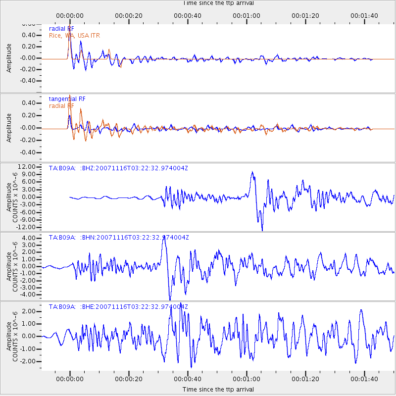
> Station B09A Rice, WA, USA > Earthquake Result Viewer
B09A Rice, WA, USA - Earthquake Result Viewer
| Earthquake location: |
Peru-Ecuador Border Region |
| Earthquake latitude/longitude: |
-2.3/-77.8 |
| Earthquake time(UTC): |
2007/11/16 (320) 03:13:00 GMT |
| Earthquake Depth: |
123 km |
| Earthquake Magnitude: |
6.3 MB, 6.8 MW, 6.7 MW |
| Earthquake Catalog/Contributor: |
WHDF/NEIC |
|
| Network: |
TA USArray Transportable Network (new EarthScope stations) |
| Station: |
B09A Rice, WA, USA |
| Lat/Lon: |
48.42 N/118.15 W |
| Elevation: |
630 m |
|
| Distance: |
61.5 deg |
| Az: |
330.626 deg |
| Baz: |
132.627 deg |
| Ray Param: |
0.060507488 |
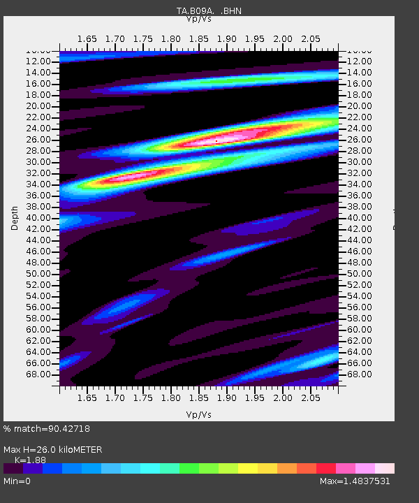
| Estimated Moho Depth: |
26.0 km |
| Estimated Crust Vp/Vs: |
1.88 |
| Assumed Crust Vp: |
6.419 km/s |
| Estimated Crust Vs: |
3.414 km/s |
| Estimated Crust Poisson's Ratio: |
0.30 |
|
| Radial Match: |
90.42718 % |
| Radial Bump: |
400 |
| Transverse Match: |
75.71926 % |
| Transverse Bump: |
400 |
| SOD ConfigId: |
2564 |
| Insert Time: |
2010-03-07 01:00:50.422 +0000 |
| GWidth: |
2.5 |
| Max Bumps: |
400 |
| Tol: |
0.001 |
|
Signal To Noise
| Channel | StoN | STA | LTA |
| TA:B09A: :BHN:20071116T03:22:32.974004Z | 3.4462044 | 5.9259787E-7 | 1.7195669E-7 |
| TA:B09A: :BHE:20071116T03:22:32.974004Z | 1.9478576 | 4.552686E-7 | 2.3372787E-7 |
| TA:B09A: :BHZ:20071116T03:22:32.974004Z | 6.8026953 | 1.9726417E-6 | 2.8997943E-7 |
| Arrivals |
| Ps | 3.7 SECOND |
| PpPs | 11 SECOND |
| PsPs/PpSs | 15 SECOND |


