You are here: Home > Network List > TA - USArray Transportable Network (new EarthScope stations) Stations List
> Station B09A Rice, WA, USA > Earthquake Result Viewer
B09A Rice, WA, USA - Earthquake Result Viewer
| Earthquake location: |
Solomon Islands |
| Earthquake latitude/longitude: |
-9.8/159.5 |
| Earthquake time(UTC): |
2007/08/16 (228) 08:39:27 GMT |
| Earthquake Depth: |
10 km |
| Earthquake Magnitude: |
6.1 MB, 6.7 MS, 6.4 MW |
| Earthquake Catalog/Contributor: |
WHDF/NEIC |
|
| Network: |
TA USArray Transportable Network (new EarthScope stations) |
| Station: |
B09A Rice, WA, USA |
| Lat/Lon: |
48.42 N/118.15 W |
| Elevation: |
630 m |
|
| Distance: |
92.3 deg |
| Az: |
41.358 deg |
| Baz: |
257.845 deg |
| Ray Param: |
0.04148454 |
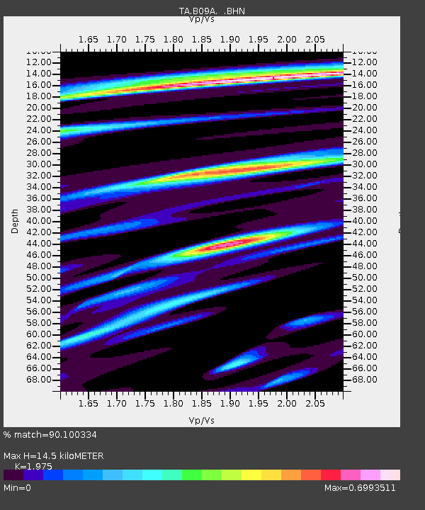
| Estimated Moho Depth: |
14.5 km |
| Estimated Crust Vp/Vs: |
1.98 |
| Assumed Crust Vp: |
6.419 km/s |
| Estimated Crust Vs: |
3.25 km/s |
| Estimated Crust Poisson's Ratio: |
0.33 |
|
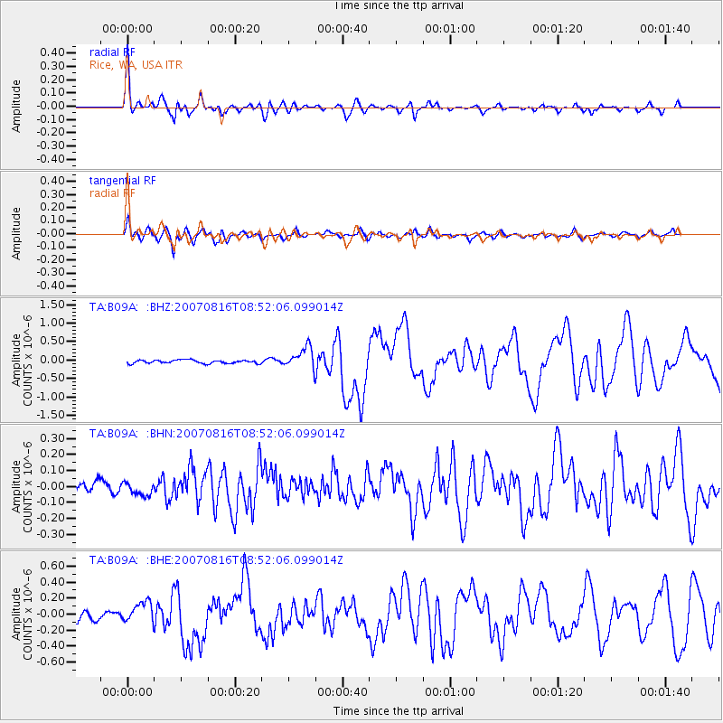
| Radial Match: |
90.100334 % |
| Radial Bump: |
400 |
| Transverse Match: |
87.06248 % |
| Transverse Bump: |
400 |
| SOD ConfigId: |
2564 |
| Insert Time: |
2010-03-07 01:00:55.714 +0000 |
| GWidth: |
2.5 |
| Max Bumps: |
400 |
| Tol: |
0.001 |
|
Signal To Noise
| Channel | StoN | STA | LTA |
| TA:B09A: :BHN:20070816T08:52:06.099014Z | 0.6288981 | 3.5731066E-8 | 5.681535E-8 |
| TA:B09A: :BHE:20070816T08:52:06.099014Z | 1.3953972 | 1.2661131E-7 | 9.0734964E-8 |
| TA:B09A: :BHZ:20070816T08:52:06.099014Z | 6.53029 | 2.934385E-7 | 4.4934986E-8 |
| Arrivals |
| Ps | 2.2 SECOND |
| PpPs | 6.6 SECOND |
| PsPs/PpSs | 8.8 SECOND |


