You are here: Home > Network List > TA - USArray Transportable Network (new EarthScope stations) Stations List
> Station B09A Rice, WA, USA > Earthquake Result Viewer
B09A Rice, WA, USA - Earthquake Result Viewer
| Earthquake location: |
Near Coast Of Peru |
| Earthquake latitude/longitude: |
-13.4/-76.6 |
| Earthquake time(UTC): |
2007/08/15 (227) 23:40:57 GMT |
| Earthquake Depth: |
39 km |
| Earthquake Magnitude: |
6.7 MB, 7.9 MS, 8.0 MW, 7.5 ME |
| Earthquake Catalog/Contributor: |
WHDF/NEIC |
|
| Network: |
TA USArray Transportable Network (new EarthScope stations) |
| Station: |
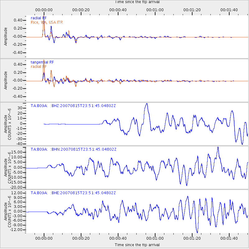
B09A Rice, WA, USA |
| Lat/Lon: |
48.42 N/118.15 W |
| Elevation: |
630 m |
|
| Distance: |
71.7 deg |
| Az: |
332.273 deg |
| Baz: |
137.178 deg |
| Ray Param: |
0.054071356 |
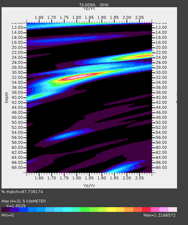
| Estimated Moho Depth: |
31.5 km |
| Estimated Crust Vp/Vs: |
1.80 |
| Assumed Crust Vp: |
6.419 km/s |
| Estimated Crust Vs: |
3.561 km/s |
| Estimated Crust Poisson's Ratio: |
0.28 |
|
| Radial Match: |
97.739174 % |
| Radial Bump: |
258 |
| Transverse Match: |
91.71017 % |
| Transverse Bump: |
400 |
| SOD ConfigId: |
2564 |
| Insert Time: |
2010-03-07 01:00:57.223 +0000 |
| GWidth: |
2.5 |
| Max Bumps: |
400 |
| Tol: |
0.001 |
|
Signal To Noise
| Channel | StoN | STA | LTA |
| TA:B09A: :BHN:20070815T23:51:45.04802Z | 21.660019 | 1.488468E-6 | 6.871961E-8 |
| TA:B09A: :BHE:20070815T23:51:45.04802Z | 9.146993 | 5.890426E-7 | 6.4397405E-8 |
| TA:B09A: :BHZ:20070815T23:51:45.04802Z | 34.22783 | 3.955359E-6 | 1.15559736E-7 |
| Arrivals |
| Ps | 4.1 SECOND |
| PpPs | 13 SECOND |
| PsPs/PpSs | 17 SECOND |


