You are here: Home > Network List > TA - USArray Transportable Network (new EarthScope stations) Stations List
> Station B09A Rice, WA, USA > Earthquake Result Viewer
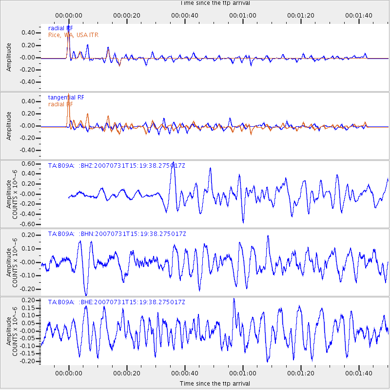
B09A Rice, WA, USA - Earthquake Result Viewer
| Earthquake location: |
Northwest Of Ryukyu Islands |
| Earthquake latitude/longitude: |
27.3/126.9 |
| Earthquake time(UTC): |
2007/07/31 (212) 15:07:35 GMT |
| Earthquake Depth: |
10 km |
| Earthquake Magnitude: |
5.5 MB, 5.7 MS, 5.9 MW, 5.9 MW |
| Earthquake Catalog/Contributor: |
WHDF/NEIC |
|
| Network: |
TA USArray Transportable Network (new EarthScope stations) |
| Station: |
B09A Rice, WA, USA |
| Lat/Lon: |
48.42 N/118.15 W |
| Elevation: |
630 m |
|
| Distance: |
84.8 deg |
| Az: |
37.333 deg |
| Baz: |
305.921 deg |
| Ray Param: |
0.04522893 |
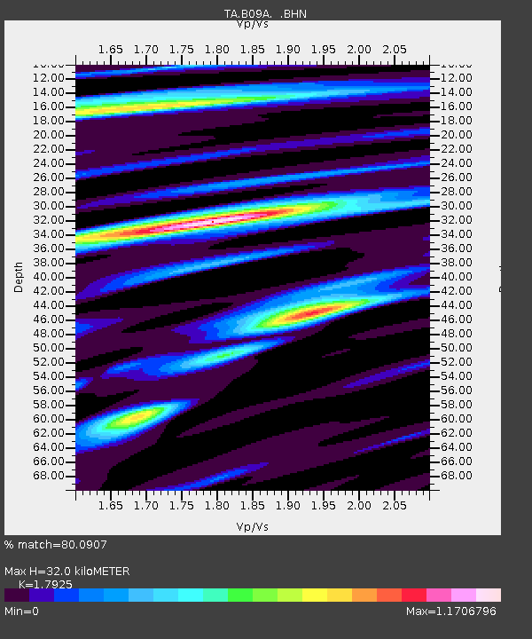
| Estimated Moho Depth: |
32.0 km |
| Estimated Crust Vp/Vs: |
1.79 |
| Assumed Crust Vp: |
6.419 km/s |
| Estimated Crust Vs: |
3.581 km/s |
| Estimated Crust Poisson's Ratio: |
0.27 |
|
| Radial Match: |
80.0907 % |
| Radial Bump: |
396 |
| Transverse Match: |
68.285194 % |
| Transverse Bump: |
400 |
| SOD ConfigId: |
2564 |
| Insert Time: |
2010-03-07 01:01:04.235 +0000 |
| GWidth: |
2.5 |
| Max Bumps: |
400 |
| Tol: |
0.001 |
|
Signal To Noise
| Channel | StoN | STA | LTA |
| TA:B09A: :BHN:20070731T15:19:38.275017Z | 1.9431306 | 7.576391E-8 | 3.8990642E-8 |
| TA:B09A: :BHE:20070731T15:19:38.275017Z | 1.8030958 | 7.068091E-8 | 3.9199755E-8 |
| TA:B09A: :BHZ:20070731T15:19:38.275017Z | 2.6207082 | 1.4950857E-7 | 5.704891E-8 |
| Arrivals |
| Ps | 4.0 SECOND |
| PpPs | 14 SECOND |
| PsPs/PpSs | 18 SECOND |


