You are here: Home > Network List > TA - USArray Transportable Network (new EarthScope stations) Stations List
> Station B09A Rice, WA, USA > Earthquake Result Viewer
B09A Rice, WA, USA - Earthquake Result Viewer
| Earthquake location: |
South Of Mariana Islands |
| Earthquake latitude/longitude: |
10.5/145.7 |
| Earthquake time(UTC): |
2007/09/30 (273) 02:08:30 GMT |
| Earthquake Depth: |
14 km |
| Earthquake Magnitude: |
6.4 MB, 7.1 MS, 6.9 MW, 6.9 MW |
| Earthquake Catalog/Contributor: |
WHDF/NEIC |
|
| Network: |
TA USArray Transportable Network (new EarthScope stations) |
| Station: |
B09A Rice, WA, USA |
| Lat/Lon: |
48.42 N/118.15 W |
| Elevation: |
630 m |
|
| Distance: |
86.3 deg |
| Az: |
41.582 deg |
| Baz: |
281.471 deg |
| Ray Param: |
0.04413984 |
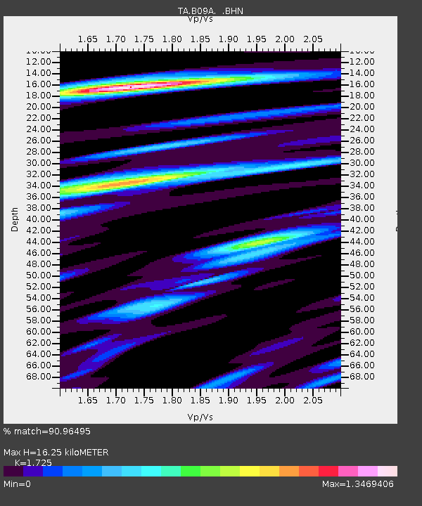
| Estimated Moho Depth: |
16.25 km |
| Estimated Crust Vp/Vs: |
1.73 |
| Assumed Crust Vp: |
6.419 km/s |
| Estimated Crust Vs: |
3.721 km/s |
| Estimated Crust Poisson's Ratio: |
0.25 |
|
| Radial Match: |
90.96495 % |
| Radial Bump: |
400 |
| Transverse Match: |
88.96312 % |
| Transverse Bump: |
400 |
| SOD ConfigId: |
2564 |
| Insert Time: |
2010-03-07 01:01:12.647 +0000 |
| GWidth: |
2.5 |
| Max Bumps: |
400 |
| Tol: |
0.001 |
|

Signal To Noise
| Channel | StoN | STA | LTA |
| TA:B09A: :BHN:20070930T02:20:39.974016Z | 1.6776841 | 1.9672105E-7 | 1.1725751E-7 |
| TA:B09A: :BHE:20070930T02:20:39.974016Z | 1.7246739 | 3.545704E-7 | 2.0558693E-7 |
| TA:B09A: :BHZ:20070930T02:20:39.974016Z | 4.737815 | 6.232135E-7 | 1.3154029E-7 |
| Arrivals |
| Ps | 1.9 SECOND |
| PpPs | 6.7 SECOND |
| PsPs/PpSs | 8.6 SECOND |


