You are here: Home > Network List > TA - USArray Transportable Network (new EarthScope stations) Stations List
> Station B09A Rice, WA, USA > Earthquake Result Viewer
B09A Rice, WA, USA - Earthquake Result Viewer
| Earthquake location: |
Kuril Islands |
| Earthquake latitude/longitude: |
46.6/153.3 |
| Earthquake time(UTC): |
2006/11/15 (319) 11:14:13 GMT |
| Earthquake Depth: |
10 km |
| Earthquake Magnitude: |
6.5 MB, 7.8 MS, 8.3 MW, 7.9 MW |
| Earthquake Catalog/Contributor: |
WHDF/NEIC |
|
| Network: |
TA USArray Transportable Network (new EarthScope stations) |
| Station: |
B09A Rice, WA, USA |
| Lat/Lon: |
48.42 N/118.15 W |
| Elevation: |
630 m |
|
| Distance: |
56.5 deg |
| Az: |
52.965 deg |
| Baz: |
304.266 deg |
| Ray Param: |
0.0640802 |
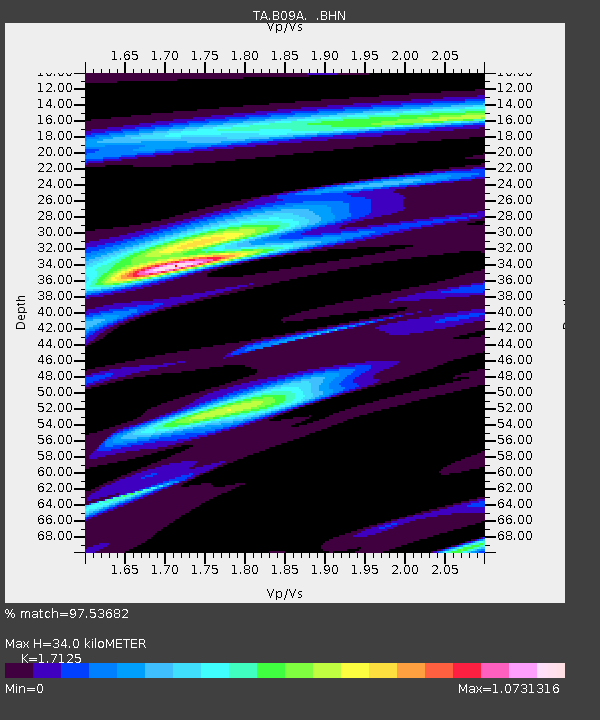
| Estimated Moho Depth: |
34.0 km |
| Estimated Crust Vp/Vs: |
1.71 |
| Assumed Crust Vp: |
6.419 km/s |
| Estimated Crust Vs: |
3.748 km/s |
| Estimated Crust Poisson's Ratio: |
0.24 |
|
| Radial Match: |
97.53682 % |
| Radial Bump: |
370 |
| Transverse Match: |
95.94045 % |
| Transverse Bump: |
400 |
| SOD ConfigId: |
2564 |
| Insert Time: |
2010-03-07 01:01:41.193 +0000 |
| GWidth: |
2.5 |
| Max Bumps: |
400 |
| Tol: |
0.001 |
|

Signal To Noise
| Channel | StoN | STA | LTA |
| TA:B09A: :BHN:20061115T11:23:24.924004Z | 2.307985 | 8.897906E-7 | 3.8552702E-7 |
| TA:B09A: :BHE:20061115T11:23:24.924004Z | 2.262097 | 7.004586E-7 | 3.0965015E-7 |
| TA:B09A: :BHZ:20061115T11:23:24.924004Z | 4.327046 | 1.6493492E-6 | 3.8117213E-7 |
| Arrivals |
| Ps | 4.0 SECOND |
| PpPs | 14 SECOND |
| PsPs/PpSs | 18 SECOND |


