You are here: Home > Network List > TA - USArray Transportable Network (new EarthScope stations) Stations List
> Station B09A Rice, WA, USA > Earthquake Result Viewer
B09A Rice, WA, USA - Earthquake Result Viewer
| Earthquake location: |
Near Coast Of Northern Chile |
| Earthquake latitude/longitude: |
-20.2/-70.0 |
| Earthquake time(UTC): |
2008/02/04 (035) 17:01:30 GMT |
| Earthquake Depth: |
44 km |
| Earthquake Magnitude: |
6.0 MB, 6.2 MS, 6.3 MW, 6.3 MW |
| Earthquake Catalog/Contributor: |
WHDF/NEIC |
|
| Network: |
TA USArray Transportable Network (new EarthScope stations) |
| Station: |
B09A Rice, WA, USA |
| Lat/Lon: |
48.42 N/118.15 W |
| Elevation: |
630 m |
|
| Distance: |
80.7 deg |
| Az: |
329.831 deg |
| Baz: |
134.866 deg |
| Ray Param: |
0.048052948 |
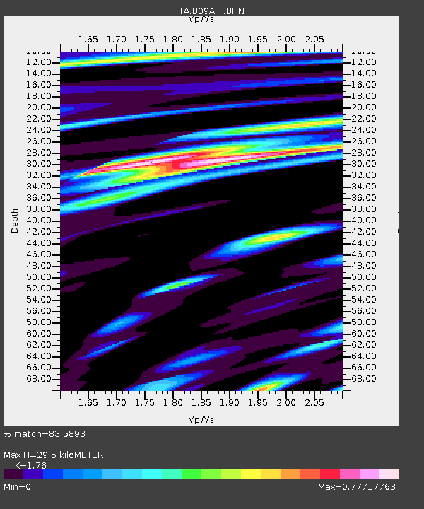
| Estimated Moho Depth: |
29.5 km |
| Estimated Crust Vp/Vs: |
1.76 |
| Assumed Crust Vp: |
6.419 km/s |
| Estimated Crust Vs: |
3.647 km/s |
| Estimated Crust Poisson's Ratio: |
0.26 |
|
| Radial Match: |
83.5893 % |
| Radial Bump: |
400 |
| Transverse Match: |
63.006428 % |
| Transverse Bump: |
396 |
| SOD ConfigId: |
2564 |
| Insert Time: |
2010-03-07 01:01:53.372 +0000 |
| GWidth: |
2.5 |
| Max Bumps: |
400 |
| Tol: |
0.001 |
|

Signal To Noise
| Channel | StoN | STA | LTA |
| TA:B09A: :BHN:20080204T17:13:08.250029Z | 2.1697454 | 6.8692896E-7 | 3.1659428E-7 |
| TA:B09A: :BHE:20080204T17:13:08.250029Z | 1.8860176 | 6.443903E-7 | 3.4166717E-7 |
| TA:B09A: :BHZ:20080204T17:13:08.250029Z | 12.598845 | 2.938841E-6 | 2.3326274E-7 |
| Arrivals |
| Ps | 3.6 SECOND |
| PpPs | 12 SECOND |
| PsPs/PpSs | 16 SECOND |


