You are here: Home > Network List > TA - USArray Transportable Network (new EarthScope stations) Stations List
> Station P07A Fallon, NV, USA > Earthquake Result Viewer
P07A Fallon, NV, USA - Earthquake Result Viewer
| Earthquake location: |
Andreanof Islands, Aleutian Is. |
| Earthquake latitude/longitude: |
50.2/-177.6 |
| Earthquake time(UTC): |
2007/08/16 (228) 04:03:03 GMT |
| Earthquake Depth: |
15 km |
| Earthquake Magnitude: |
5.8 MB |
| Earthquake Catalog/Contributor: |
WHDF/NEIC |
|
| Network: |
TA USArray Transportable Network (new EarthScope stations) |
| Station: |
P07A Fallon, NV, USA |
| Lat/Lon: |
39.54 N/118.89 W |
| Elevation: |
1219 m |
|
| Distance: |
41.9 deg |
| Az: |
81.481 deg |
| Baz: |
304.798 deg |
| Ray Param: |
0.07348006 |
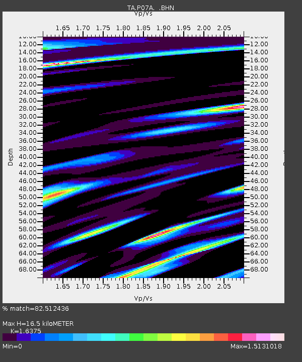
| Estimated Moho Depth: |
16.5 km |
| Estimated Crust Vp/Vs: |
1.64 |
| Assumed Crust Vp: |
6.279 km/s |
| Estimated Crust Vs: |
3.834 km/s |
| Estimated Crust Poisson's Ratio: |
0.20 |
|
| Radial Match: |
82.512436 % |
| Radial Bump: |
400 |
| Transverse Match: |
63.491142 % |
| Transverse Bump: |
400 |
| SOD ConfigId: |
2564 |
| Insert Time: |
2010-03-07 01:02:03.706 +0000 |
| GWidth: |
2.5 |
| Max Bumps: |
400 |
| Tol: |
0.001 |
|
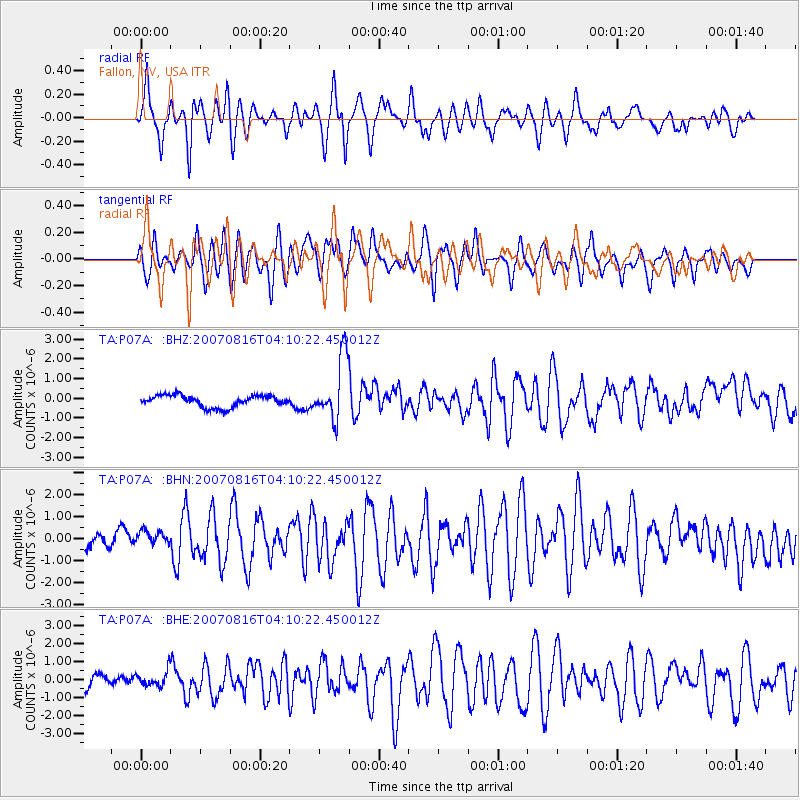
Signal To Noise
| Channel | StoN | STA | LTA |
| TA:P07A: :BHN:20070816T04:10:22.450012Z | 1.0354152 | 3.9234376E-7 | 3.7892408E-7 |
| TA:P07A: :BHE:20070816T04:10:22.450012Z | 1.4383775 | 4.3417896E-7 | 3.0185328E-7 |
| TA:P07A: :BHZ:20070816T04:10:22.450012Z | 5.424804 | 1.6061533E-6 | 2.960758E-7 |
| Arrivals |
| Ps | 1.8 SECOND |
| PpPs | 6.5 SECOND |
| PsPs/PpSs | 8.3 SECOND |


