
Station TA P07A - Fallon, NV, USA
Network: TA - USArray Transportable Network (new EarthScope stations)
Nearby stations (2 deg radius)
| Station | Name | (Lat, Lon) | Start / End | Elevation |
| P07A | Fallon, NV, USA | (39.54, -118.89) | 2006-02-25 / 2499-01-01 | 1.2 km |
| Crust2 Type: | M7,medium thick extended crust, 0.5 km seds. |
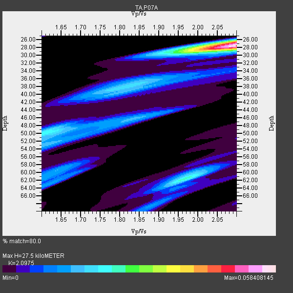
| Thickness Estimate: | 28 km |
| Thickness StdDev: | 7.4 km |
| Vp/Vs Estimate: | 2.10 |
| Vp/Vs StdDev: | 0.03 |
| Vs Estimate: | 2.993 km/s |
| Poisson's Ratio: | 0.35 |
| Peak Value: | 0.06 |
| Assumed Vp: | 6.279 km/s |
| Ps Weight: | 0.33333334 |
| PpPs Weight: | 0.33333334 |
| PsPs Weight: | 0.33333328 |
| Residual Complexity: | 0.671 |
| Nearby stations H: | +- |
| (2.0 deg) Vp/Vs: | +- |
6 with match > 90% ( 31.578947 %) and 19 with match > 80% ( 100.0 %) out of 19.
Download stack as xyz text file.
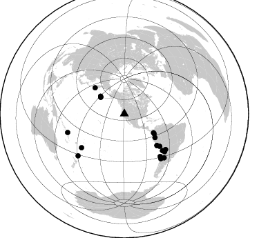
Azimuth Distribution of Events:
Prior Results for this Station
| Study | Thickness | Vp/Vs | Vp | Vs | Poissons Ratio | Extra |
| EARS | 28 km | 2.10 | 6.279 km/s | 2.993 km/s | 0.35 | |
| Crust2.0 | 35 km | 1.78 | 6.279 km/s | 3.533 km/s | 0.27 | M7,medium thick extended crust, 0.5 km seds. |
| Global Maxima | 28 km | 2.10 | 6.279 km/s | 2.993 km/s | 0.35 | amp=0.058408145 |
| Local Maxima 1 | 26 km | 2.10 | 6.279 km/s | 2.993 km/s | 0.35 | amp=0.02682108 |
| Local Maxima 2 | 62 km | 1.97 | 6.279 km/s | 3.191 km/s | 0.33 | amp=0.02454406 |
| Local Maxima 3 | 38 km | 1.82 | 6.279 km/s | 3.445 km/s | 0.28 | amp=0.017799905 |
| Local Maxima 4 | 49 km | 1.64 | 6.279 km/s | 3.834 km/s | 0.20 | amp=0.01647536 |
| Predicted Arrivals for vertical incidence (zero ray parameter) | |
| Ps | 4.81 SECOND |
| PpPs | 13.57 SECOND |
| PsPs/PpSs | 18.37 SECOND |
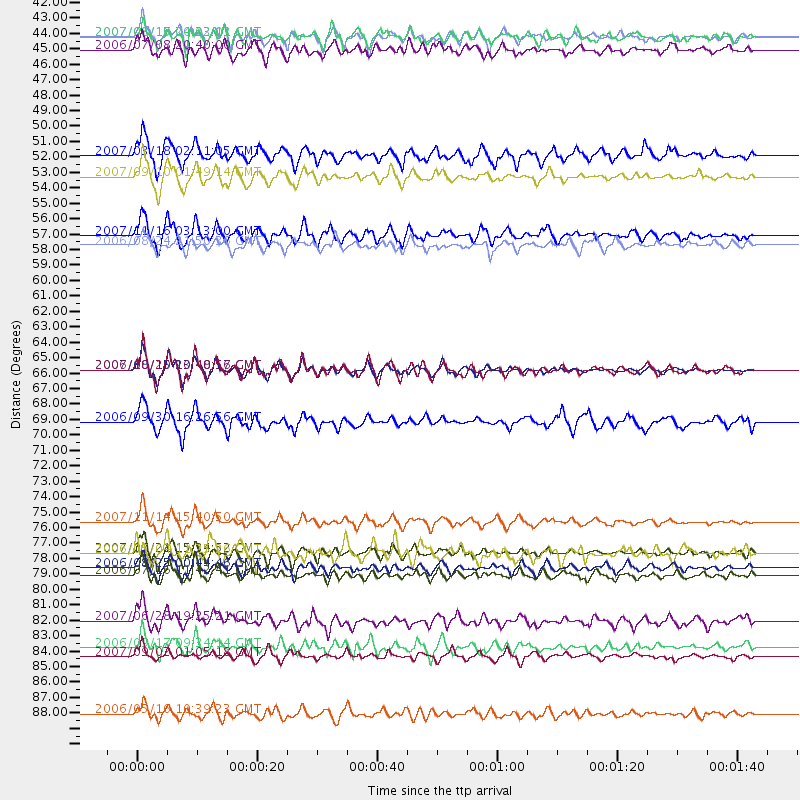
Events Processed for this Station
Download zip of receiver functions as SAC
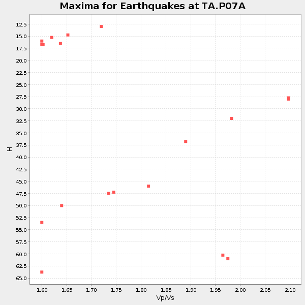
Plot maxima for each earthquake.
Events Used in the Stack
(19 events)| Radial Match | Distance | Baz | FERegion | Time | Lat/Lon | Depth | Magnitude |
| 93.17636 | 76.6 deg | 134.054 deg | Northern Chile | 2007/11/14 15:40:50 GMT | (-22.2, -69.9) | 40 km | 6.7 MB, 7.4 MS, 7.7 MW, 7.4 ME |
| 93.03408 | 65.7 deg | 134.093 deg | Near Coast Of Peru | 2007/08/15 23:40:57 GMT | (-13.4, -76.6) | 39 km | 6.7 MB, 7.9 MS, 8.0 MW, 7.5 ME |
| 91.150665 | 65.8 deg | 134.202 deg | Near Coast Of Peru | 2006/10/20 10:48:56 GMT | (-13.5, -76.7) | 23 km | 5.9 MB, 6.6 MS, 6.7 MW, 6.6 MW |
| 90.62999 | 41.9 deg | 304.913 deg | Andreanof Islands, Aleutian Is. | 2007/08/15 20:22:11 GMT | (50.3, -177.5) | 9.0 km | 6.3 MB, 6.2 MS, 6.4 MW, 5.9 ML |
| 90.48892 | 78.9 deg | 130.919 deg | Jujuy Province, Argentina | 2007/07/21 15:34:52 GMT | (-22.2, -65.8) | 290 km | 5.8 MB, 6.4 MW, 6.3 MW |
| 90.00758 | 56.1 deg | 127.787 deg | Peru-Ecuador Border Region | 2007/11/16 03:13:00 GMT | (-2.3, -77.8) | 123 km | 6.3 MB, 6.8 MW, 6.7 MW |
| 88.26385 | 52.0 deg | 123.835 deg | Near West Coast Of Colombia | 2007/09/10 01:49:14 GMT | (3.0, -78.0) | 31 km | 6.1 MB, 6.7 MS, 6.8 MW |
| 88.21169 | 85.6 deg | 137.88 deg | San Juan Province, Argentina | 2006/09/17 09:34:14 GMT | (-31.7, -67.2) | 142 km | 5.7 MB, 6.2 MW, 6.2 MW |
| 85.60096 | 86.3 deg | 251.795 deg | Santa Cruz Islands | 2007/09/02 01:05:18 GMT | (-11.6, 165.8) | 35 km | 5.9 MB, 7.3 MS, 7.2 MW, 6.9 ME |
| 84.69842 | 79.9 deg | 133.258 deg | Chile-Argentina Border Region | 2006/08/25 00:44:46 GMT | (-24.4, -67.0) | 184 km | 5.9 MB, 6.6 MW, 6.6 MW |
| 83.40227 | 56.8 deg | 311.615 deg | Near East Coast Of Kamchatka | 2006/08/24 21:50:36 GMT | (51.1, 157.5) | 43 km | 5.9 MB, 6.2 MS, 6.5 MW, 6.5 MW |
| 83.13523 | 69.5 deg | 132.532 deg | Southern Peru | 2006/09/30 16:26:56 GMT | (-15.6, -73.2) | 107 km | 5.6 MB, 6.0 MW, 5.9 MW |
| 82.836296 | 83.7 deg | 140.902 deg | Near Coast Of Central Chile | 2007/06/28 19:25:21 GMT | (-32.0, -71.3) | 69 km | 5.5 MB, 5.7 MW, 5.6 MW |
| 82.512436 | 41.9 deg | 304.798 deg | Andreanof Islands, Aleutian Is. | 2007/08/16 04:03:03 GMT | (50.2, -177.6) | 15 km | 5.8 MB |
| 82.46713 | 42.9 deg | 306.47 deg | Andreanof Islands, Aleutian Is. | 2006/07/08 20:40:00 GMT | (51.2, -179.3) | 22 km | 6.2 MB, 6.4 MS, 6.6 MW, 6.6 MW |
| 82.27163 | 80.5 deg | 139.876 deg | Off Coast Of Central Chile | 2006/07/16 11:42:41 GMT | (-28.7, -72.5) | 10 km | 5.9 MB, 5.7 MS, 6.2 MW, 6.2 MW |
| 81.37265 | 90.4 deg | 227.792 deg | Kermadec Islands Region | 2006/05/16 10:39:23 GMT | (-31.8, -179.3) | 152 km | 6.8 MB, 7.4 MW, 7.4 MW |
| 81.08578 | 50.4 deg | 123.036 deg | South Of Panama | 2007/03/18 02:11:05 GMT | (4.6, -78.5) | 8.0 km | 6.4 MB, 5.7 MS, 6.2 MW, 6.1 MW |
| 80.814156 | 78.9 deg | 231.586 deg | Tonga Islands | 2006/05/04 11:25:26 GMT | (-20.6, -174.0) | 11 km | 5.7 MB, 5.8 MS, 6.0 MW, 5.8 MW |
Losers
(0 events)| Radial Match | Distance | Baz | FERegion | Time | Lat/Lon | Depth | Magnitude | Reason |
