You are here: Home > Network List > TA - USArray Transportable Network (new EarthScope stations) Stations List
> Station P07A Fallon, NV, USA > Earthquake Result Viewer
P07A Fallon, NV, USA - Earthquake Result Viewer
| Earthquake location: |
Near Coast Of Peru |
| Earthquake latitude/longitude: |
-13.4/-76.6 |
| Earthquake time(UTC): |
2007/08/15 (227) 23:40:57 GMT |
| Earthquake Depth: |
39 km |
| Earthquake Magnitude: |
6.7 MB, 7.9 MS, 8.0 MW, 7.5 ME |
| Earthquake Catalog/Contributor: |
WHDF/NEIC |
|
| Network: |
TA USArray Transportable Network (new EarthScope stations) |
| Station: |
P07A Fallon, NV, USA |
| Lat/Lon: |
39.54 N/118.89 W |
| Elevation: |
1219 m |
|
| Distance: |
65.7 deg |
| Az: |
325.202 deg |
| Baz: |
134.093 deg |
| Ray Param: |
0.05800244 |
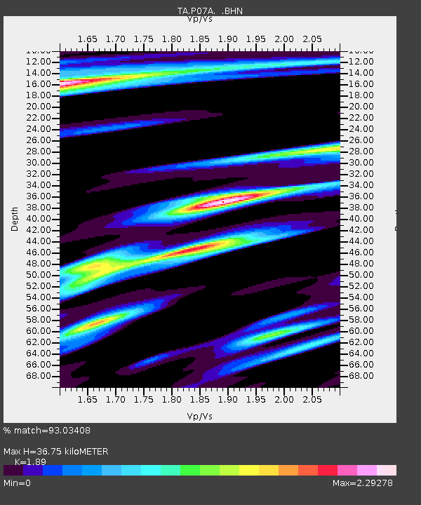
| Estimated Moho Depth: |
36.75 km |
| Estimated Crust Vp/Vs: |
1.89 |
| Assumed Crust Vp: |
6.279 km/s |
| Estimated Crust Vs: |
3.322 km/s |
| Estimated Crust Poisson's Ratio: |
0.31 |
|
| Radial Match: |
93.03408 % |
| Radial Bump: |
400 |
| Transverse Match: |
92.77633 % |
| Transverse Bump: |
400 |
| SOD ConfigId: |
2564 |
| Insert Time: |
2010-03-07 01:02:06.306 +0000 |
| GWidth: |
2.5 |
| Max Bumps: |
400 |
| Tol: |
0.001 |
|

Signal To Noise
| Channel | StoN | STA | LTA |
| TA:P07A: :BHN:20070815T23:51:07.90001Z | 3.641197 | 1.0610174E-6 | 2.913925E-7 |
| TA:P07A: :BHE:20070815T23:51:07.90001Z | 3.781259 | 1.350806E-6 | 3.5723707E-7 |
| TA:P07A: :BHZ:20070815T23:51:07.90001Z | 10.785892 | 2.7234532E-6 | 2.5250145E-7 |
| Arrivals |
| Ps | 5.4 SECOND |
| PpPs | 16 SECOND |
| PsPs/PpSs | 22 SECOND |


